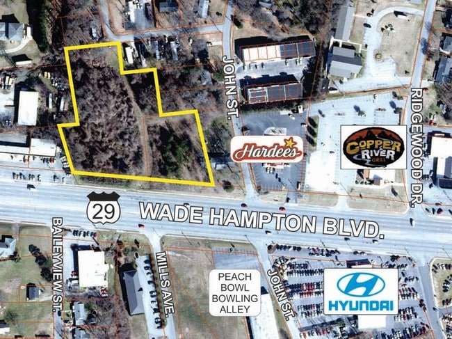
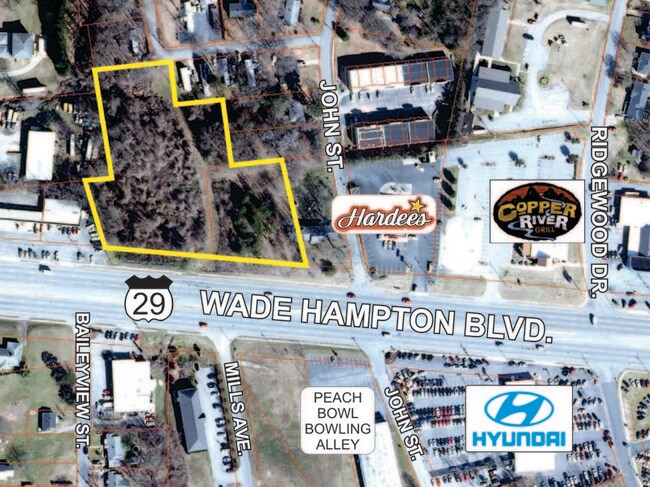
Property Record
14620 E Wade Hampton Blvd, Greer, SC 29651

Save to a Folder
{{folder.Name}}
{{folder.ListingIds.length}} Properties
{{folder.ListingIds.length}} Property
Create a New Folder
Property Detail
14620 E Wade Hampton Blvd
Greenville/Spartanburg
P/O LOT 90 & 91 EMMA CANNON SUB & ADJ TR DB 56L-427 DB 133N-353 DB 50E-979 DB 45P-259 PB 26-488-491
Spartanburg, SC
SPARTANBURG
9-03-09-009.01
South Carolina
Commercialacreage
90,91
2024
2.83 AC
2025
Upper Spartanburg County
023301
NEARBY LISTINGS FOR SALE OR LEASE
DEMOGRAPHICS near 14620 E Wade Hampton Blvd
1 mile
3 mile
5 mile
2025 Total Population
6,219
37,145
82,750
2030 Population
6,843
40,661
90,540
Pop Growth 2025-2030
+ 10.03%
+ 9.47%
+ 9.41%
Average Age
39
40
40
2025 Total Households
2,638
15,062
32,218
HH Growth 2025-2030
+ 10.08%
+ 9.55%
+ 9.53%
Median Household Inc
$60,484
$63,484
$74,748
Avg Household Size
2.30
2.40
2.50
2025 Avg HH Vehicles
2.00
2.00
2.00
Median Home Value
$232,385
$252,383
$280,378
Median Year Built
1981
1991
1997
Nearby Places
Map Layers
Map Styles
 Street
 Aerial
Layers
 Traffic
 Biking
Places
Listings with unknown addresses are not visible on the map
- Restaurants
- Banks
- Shops
- Fitness
- Groceries
PUBLIC TRANSPORTATION
AIRPORT
Greenville Spartanburg International
Drive
Walk
Distance
Greenville Spartanburg International
15 min
6.1 mi
Freight Ports
North Charleston Terminal
Drive
Walk
Distance
North Charleston Terminal
236 min
205.8 mi
SALE & LEASE HISTORY
LISTING DATE
SALE/LEASE

Sep 24, 2016
For Sale
Aug 15, 2017
For Sale
Aug 13, 2019
For Sale
Nearby Properties
Address
Land Use
TOTAL SIZE
Lot Size
Zoning
Address
Land Use
TOTAL SIZE
Lot Size
Zoning
227,627 SF
21.37 AC
Address
Land Use
TOTAL SIZE
Lot Size
Zoning
14.20 AC
UNZONED
Address
Land Use
TOTAL SIZE
Lot Size
Zoning
532 SF
72.61 AC
I1
Address
Land Use
TOTAL SIZE
Lot Size
Zoning
13.25 AC
I1
Address
Land Use
TOTAL SIZE
Lot Size
Zoning
5.07 AC
C2
Address
Land Use
TOTAL SIZE
Lot Size
Zoning
8.30 AC
RM
Address
Land Use
TOTAL SIZE
Lot Size
Zoning
0.42 AC
OD
Address
Land Use
TOTAL SIZE
Lot Size
Zoning
99.01 AC
I1
Address
Land Use
TOTAL SIZE
Lot Size
Zoning
14.33 AC
I1
Address
Land Use
TOTAL SIZE
Lot Size
Zoning
48.84 AC
C2
Address
Land Use
TOTAL SIZE
Lot Size
Zoning
8.22 AC
I1
Address
Land Use
TOTAL SIZE
Lot Size
Zoning
1.05 AC
S1
Address
Land Use
TOTAL SIZE
Lot Size
Zoning
6.81 AC
RM
Address
Land Use
TOTAL SIZE
Lot Size
Zoning
1.90 AC
I1
Address
Land Use
TOTAL SIZE
Lot Size
Zoning
10.20 AC
S1
Address
Land Use
TOTAL SIZE
Lot Size
Zoning
5.23 AC
I1
Address
Land Use
TOTAL SIZE
Lot Size
Zoning
5.15 AC
R15
Address
Land Use
TOTAL SIZE
Lot Size
Zoning
12.91 AC
RM
Address
Land Use
TOTAL SIZE
Lot Size
Zoning
11.70 AC
C2
Address
Land Use
TOTAL SIZE
Lot Size
Zoning
2.15 AC
C2
Address
Land Use
TOTAL SIZE
Lot Size
Zoning
0.51 AC
C1
Address
Land Use
TOTAL SIZE
Lot Size
Zoning
1.15 AC
C1
Address
Land Use
TOTAL SIZE
Lot Size
Zoning
4.07 AC
OD
Address
Land Use
TOTAL SIZE
Lot Size
Zoning
6.90 AC
I1
Address
Land Use
TOTAL SIZE
Lot Size
Zoning
710,705 SF
34.03 AC
Address
Land Use
TOTAL SIZE
Lot Size
Zoning
91,927 SF
21.14 AC
Address
Land Use
TOTAL SIZE
Lot Size
Zoning
16,592 SF
15.43 AC
Address
Land Use
TOTAL SIZE
Lot Size
Zoning
34.30 AC
UNZONED
Address
Land Use
TOTAL SIZE
Lot Size
Zoning
7.12 AC
R15
Address
Land Use
TOTAL SIZE
Lot Size
Zoning
3.41 AC
C2
The World's #1 Commercial Real Estate Marketplace
Connect with us
© 2026 CoStar Group
The information above has been obtained from sources believed reliable. While we do not doubt its accuracy we have not verified it and make no guarantee, warranty or representation about it. It is your responsibility to independently confirm its accuracy and completeness. Any projections, opinions, assumptions, or estimates used are for example only and do not represent the current or future performance of the property. The value of this transaction to you depends on tax and other factors which should be evaluated by your tax, financial, and legal advisors. You and your advisors should conduct a careful, independent investigation of the property to determine to your satisfaction the suitability of the property for your needs.