Property Record
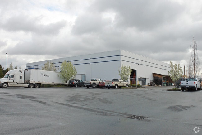
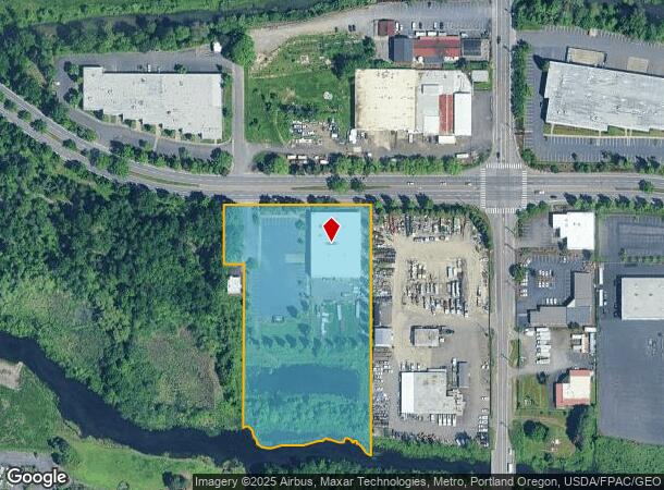
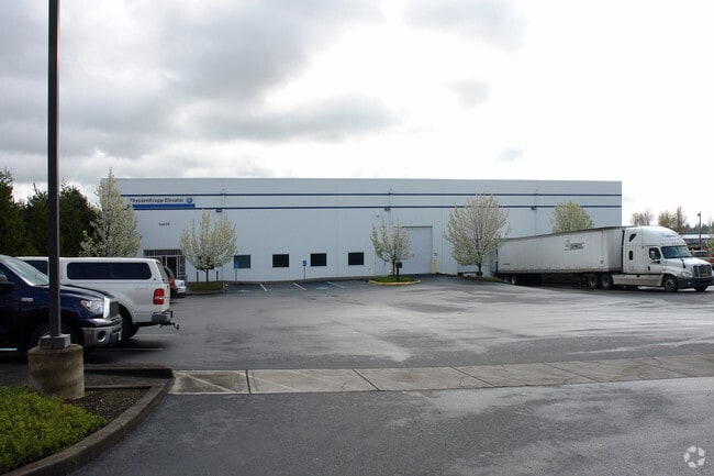
14626 Ne Airport Way, Portland, OR 97230

NEARBY LISTINGS FOR SALE OR LEASE
Property Detail
14626 Ne Airport Way
R318587
SECTION 24 1N 2E, TL 1000 4.62 ACRES
Industrialgeneral
Multnomah
ARE
Oregon
53011C0525D
1
2025
4.62 AC
2025
East Columbia Corridor
007300
Portland
20,000 SF
Portland-Vancouver-Hillsboro, OR-WA
DEMOGRAPHICS near 14626 Ne Airport Way
1 Mile
3 Mile
5 Mile
2024 Total Population
5,690
77,532
299,767
2029 Population
5,555
76,646
300,500
Pop Growth 2024-2029
(2.37%)
(1.14%)
+ 0.24%
Average Age
43
41
40
2024 Total Households
2,116
29,350
112,853
HH Growth 2024-2029
(2.65%)
(1.25%)
+ 0.18%
Median Household Inc
$67,163
$66,661
$69,126
Avg Household Size
2.50
2.50
2.50
2024 Avg HH Vehicles
2.00
2.00
2.00
Median Home Value
$434,104
$417,528
$421,320
Median Year Built
1975
1977
1978
Nearby Places
Map Layers
Map Styles
 Street
 Aerial
- Restaurants
- Banks
- Shops
- Fitness
- Groceries
PUBLIC TRANSPORTATION
AIRPORT
Portland International
DRIVE
WALK
Distance
Portland International
11 min
4.8 mi
Freight Ports
Port of Vancouver
DRIVE
WALK
Distance
Port of Vancouver
26 min
13.7 mi
Nearby Properties
Address
Land Use
TOTAL SIZE
Lot Size
Zoning
Address
Land Use
TOTAL SIZE
Lot Size
Zoning
21.39 AC
NULL
Address
Land Use
TOTAL SIZE
Lot Size
Zoning
3,800 SF
27.96 AC
LI
Address
Land Use
TOTAL SIZE
Lot Size
Zoning
273,811 SF
6.39 AC
NULL
Address
Land Use
TOTAL SIZE
Lot Size
Zoning
236,035 SF
13.01 AC
R7
Address
Land Use
TOTAL SIZE
Lot Size
Zoning
197,027 SF
28.54 AC
R7H
Address
Land Use
TOTAL SIZE
Lot Size
Zoning
64.20 AC
HI
Address
Land Use
TOTAL SIZE
Lot Size
Zoning
356,805 SF
27.10 AC
EG2
Address
Land Use
TOTAL SIZE
Lot Size
Zoning
339,894 SF
27.82 AC
R-22
Address
Land Use
TOTAL SIZE
Lot Size
Zoning
140,000 SF
14.53 AC
R7
Address
Land Use
TOTAL SIZE
Lot Size
Zoning
365,000 SF
38.87 AC
GI
Address
Land Use
TOTAL SIZE
Lot Size
Zoning
285,765 SF
14.41 AC
R-22
Address
Land Use
TOTAL SIZE
Lot Size
Zoning
698,484 SF
34.21 AC
GI
Address
Land Use
TOTAL SIZE
Lot Size
Zoning
273,844 SF
13.09 AC
R-22
Address
Land Use
TOTAL SIZE
Lot Size
Zoning
60,788 SF
10.21 AC
GI
Address
Land Use
TOTAL SIZE
Lot Size
Zoning
378,000 SF
18.91 AC
LI
Address
Land Use
TOTAL SIZE
Lot Size
Zoning
21.39 AC
HI
Address
Land Use
TOTAL SIZE
Lot Size
Zoning
184,000 SF
18.88 AC
EG2
Address
Land Use
TOTAL SIZE
Lot Size
Zoning
58,843 SF
4.53 AC
EG2
Address
Land Use
TOTAL SIZE
Lot Size
Zoning
53.15 AC
IG2
Address
Land Use
TOTAL SIZE
Lot Size
Zoning
489,695 SF
23.76 AC
IG2P
Address
Land Use
TOTAL SIZE
Lot Size
Zoning
316,197 SF
11.49 AC
R-30
Address
Land Use
TOTAL SIZE
Lot Size
Zoning
175,276 SF
13.05 AC
IG2
Address
Land Use
TOTAL SIZE
Lot Size
Zoning
99,100 SF
1.31 AC
CS
Address
Land Use
TOTAL SIZE
Lot Size
Zoning
492,161 SF
28.13 AC
IG2
Address
Land Use
TOTAL SIZE
Lot Size
Zoning
Address
Land Use
TOTAL SIZE
Lot Size
Zoning
357,603 SF
22.69 AC
GI
Address
Land Use
TOTAL SIZE
Lot Size
Zoning
172,814 SF
10 AC
R-30
Address
Land Use
TOTAL SIZE
Lot Size
Zoning
45.53 AC
IG2
Address
Land Use
TOTAL SIZE
Lot Size
Zoning
Address
Land Use
TOTAL SIZE
Lot Size
Zoning
3,998 SF
26.98 AC
IG2
The World's #1 Commercial Real Estate Marketplace
Connect with us
© 2025 CoStar Group
The information above has been obtained from sources believed reliable. While we do not doubt its accuracy we have not verified it and make no guarantee, warranty or representation about it. It is your responsibility to independently confirm its accuracy and completeness. Any projections, opinions, assumptions, or estimates used are for example only and do not represent the current or future performance of the property. The value of this transaction to you depends on tax and other factors which should be evaluated by your tax, financial, and legal advisors. You and your advisors should conduct a careful, independent investigation of the property to determine to your satisfaction the suitability of the property for your needs.