Property Record
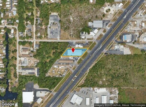
14627 Us Highway 19, Hudson, FL 34667

NEARBY LISTINGS FOR SALE OR LEASE
Property Detail
14627 Us Highway 19
Tampa-St. Petersburg-Clearwater, FL
U.S. 19 No. 9 Addn
27-24-16-0010-00C00-0030
US 19 NO 9 ADDITION PB 5 PG 66 LOT 3-5 BLOCK C;TOGETHER WITH EASEMENT FOR INGRESS & EGRESS PER OR 1540 PG 1079 OR 9030 PG 3626
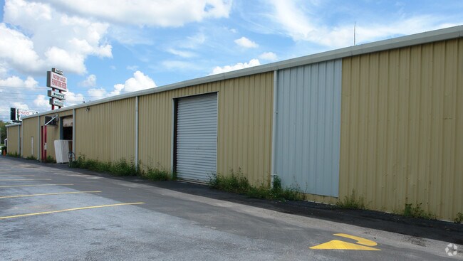
Storebuilding
Pasco
AE
Florida
12101C0177G
3
2024
1.03 AC
2025
Pasco County
030102
Tampa/St Petersburg
16,000 SF
DEMOGRAPHICS near 14627 Us Highway 19
1 Mile
3 Mile
5 Mile
2024 Total Population
3,858
35,296
74,295
2029 Population
4,664
42,462
89,216
Pop Growth 2024-2029
+ 20.89%
+ 20.30%
+ 20.08%
Average Age
54
50
48
2024 Total Households
1,928
16,340
33,131
HH Growth 2024-2029
+ 20.90%
+ 20.34%
+ 20.13%
Median Household Inc
$40,818
$44,483
$44,371
Avg Household Size
1.90
2.10
2.20
2024 Avg HH Vehicles
1.00
1.00
1.00
Median Home Value
$206,459
$173,692
$154,292
Median Year Built
1982
1982
1980
Nearby Places
Map Layers
Map Styles
 Street
 Aerial
- Restaurants
- Banks
- Shops
- Fitness
- Groceries
PUBLIC TRANSPORTATION
AIRPORT
St Pete-Clearwater International
DRIVE
WALK
Distance
St Pete-Clearwater International
56 min
35.0 mi
Tampa International
DRIVE
WALK
Distance
Tampa International
59 min
40.5 mi
Freight Ports
Port of Tampa Bay
DRIVE
WALK
Distance
Port of Tampa Bay
72 min
44.1 mi
Nearby Properties
Address
Land Use
TOTAL SIZE
Lot Size
Zoning
Address
Land Use
TOTAL SIZE
Lot Size
Zoning
414,111 SF
23.78 AC
C1
Address
Land Use
TOTAL SIZE
Lot Size
Zoning
459,499 SF
100 AC
AR
Address
Land Use
TOTAL SIZE
Lot Size
Zoning
106,741 SF
27.67 AC
MF1
Address
Land Use
TOTAL SIZE
Lot Size
Zoning
217,758 SF
34.95 AC
C2
Address
Land Use
TOTAL SIZE
Lot Size
Zoning
190,794 SF
10.88 AC
C2
Address
Land Use
TOTAL SIZE
Lot Size
Zoning
75,205 SF
12.71 AC
PUD
Address
Land Use
TOTAL SIZE
Lot Size
Zoning
48,470 SF
4.19 AC
MPUD
Address
Land Use
TOTAL SIZE
Lot Size
Zoning
80,053 SF
5.43 AC
C2
Address
Land Use
TOTAL SIZE
Lot Size
Zoning
90,113 SF
8.22 AC
C2
Address
Land Use
TOTAL SIZE
Lot Size
Zoning
83,363 SF
5.97 AC
C2
Address
Land Use
TOTAL SIZE
Lot Size
Zoning
38,187 SF
6.48 AC
MPUD
Address
Land Use
TOTAL SIZE
Lot Size
Zoning
80,025 SF
10.55 AC
MF2
Address
Land Use
TOTAL SIZE
Lot Size
Zoning
171,441 SF
8.70 AC
MF2
Address
Land Use
TOTAL SIZE
Lot Size
Zoning
59,228 SF
3.43 AC
PUD
Address
Land Use
TOTAL SIZE
Lot Size
Zoning
188,871 SF
8.44 AC
C1
Address
Land Use
TOTAL SIZE
Lot Size
Zoning
60,109 SF
2.77 AC
C3
Address
Land Use
TOTAL SIZE
Lot Size
Zoning
49,118 SF
7.72 AC
C2
Address
Land Use
TOTAL SIZE
Lot Size
Zoning
48,098 SF
2.52 AC
C2
Address
Land Use
TOTAL SIZE
Lot Size
Zoning
41,120 SF
2.47 AC
PUD
Address
Land Use
TOTAL SIZE
Lot Size
Zoning
41,120 SF
1.51 AC
PUD
Address
Land Use
TOTAL SIZE
Lot Size
Zoning
94,431 SF
10.79 AC
C2
Address
Land Use
TOTAL SIZE
Lot Size
Zoning
224,941 SF
23.03 AC
C2
Address
Land Use
TOTAL SIZE
Lot Size
Zoning
35,992 SF
9.83 AC
C2
Address
Land Use
TOTAL SIZE
Lot Size
Zoning
53,406 SF
9.11 AC
C2
Address
Land Use
TOTAL SIZE
Lot Size
Zoning
67,553 SF
14.84 AC
C2
Address
Land Use
TOTAL SIZE
Lot Size
Zoning
33,160 SF
8.53 AC
C2
Address
Land Use
TOTAL SIZE
Lot Size
Zoning
16,030 SF
3.53 AC
R4
Address
Land Use
TOTAL SIZE
Lot Size
Zoning
61,388 SF
5.44 AC
PUD
Address
Land Use
TOTAL SIZE
Lot Size
Zoning
64,000 SF
4.24 AC
I2
Address
Land Use
TOTAL SIZE
Lot Size
Zoning
28,784 SF
1.02 AC
PUD
The World's #1 Commercial Real Estate Marketplace
Connect with us
© 2025 CoStar Group
The information above has been obtained from sources believed reliable. While we do not doubt its accuracy we have not verified it and make no guarantee, warranty or representation about it. It is your responsibility to independently confirm its accuracy and completeness. Any projections, opinions, assumptions, or estimates used are for example only and do not represent the current or future performance of the property. The value of this transaction to you depends on tax and other factors which should be evaluated by your tax, financial, and legal advisors. You and your advisors should conduct a careful, independent investigation of the property to determine to your satisfaction the suitability of the property for your needs.