Property Record
14627 Zubrick Rd, Roanoke, IN 46783
NEARBY LISTINGS FOR SALE OR LEASE
-
-
View all Roanoke listings for sale on LoopNet.com
Property Detail
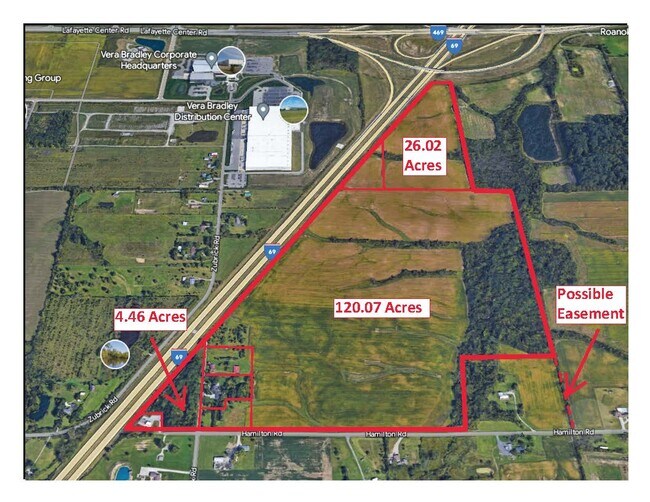
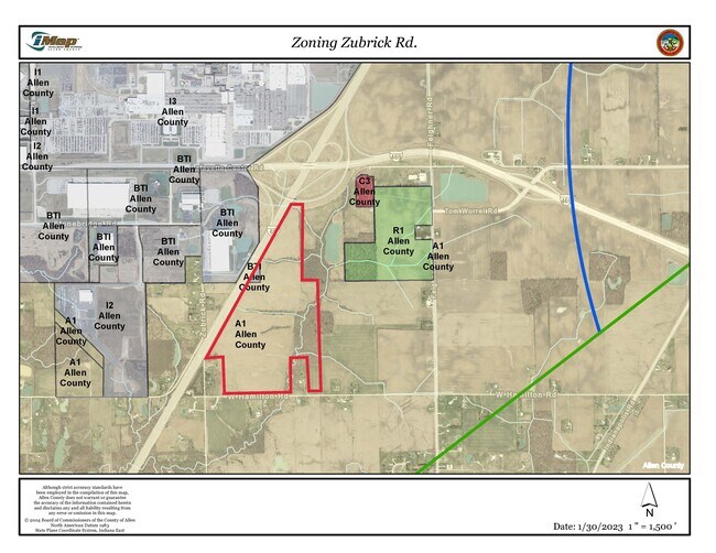
14627 Zubrick Rd
02-16-21-300-003.000-048
SE1/4 SE1/4 S OF I-69 EX SW .86 A SEC 20
Agriculturalland
Allen
X
Indiana
18069C0200D
152.19 AC
2023
Outlying Allen County
2024
Fort Wayne
011701
Fort Wayne, IN
DEMOGRAPHICS near 14627 Zubrick Rd
1 Mile
3 Mile
5 Mile
2024 Total Population
199
3,600
10,407
2029 Population
205
3,670
10,587
Pop Growth 2024-2029
+ 3.02%
+ 1.94%
+ 1.73%
Average Age
41
41
41
2024 Total Households
71
1,310
3,955
HH Growth 2024-2029
+ 2.82%
+ 1.91%
+ 1.64%
Median Household Inc
$101,471
$97,969
$89,261
Avg Household Size
2.80
2.80
2.60
2024 Avg HH Vehicles
3.00
3.00
2.00
Median Home Value
$250,000
$259,077
$249,942
Median Year Built
1978
1986
1987
Nearby Places
Map Layers
Map Styles
 Street
 Aerial
- Restaurants
- Banks
- Shops
- Fitness
- Groceries
PUBLIC TRANSPORTATION
AIRPORT
Fort Wayne International
DRIVE
WALK
Distance
Fort Wayne International
19 min
7.1 mi
Freight Ports
Port of Toledo
DRIVE
WALK
Distance
Port of Toledo
152 min
118.7 mi
SALE & LEASE HISTORY
LISTING DATE
SALE/LEASE

Mar 14, 2023
For Sale
Nearby Properties
Address
Land Use
TOTAL SIZE
Lot Size
Zoning
Address
Land Use
TOTAL SIZE
Lot Size
Zoning
5,843,317 SF
704.47 AC
Address
Land Use
TOTAL SIZE
Lot Size
Zoning
806,403 SF
61.42 AC
Address
Land Use
TOTAL SIZE
Lot Size
Zoning
427,200 SF
68.74 AC
Address
Land Use
TOTAL SIZE
Lot Size
Zoning
181,852 SF
16.38 AC
Address
Land Use
TOTAL SIZE
Lot Size
Zoning
150,600 SF
15.65 AC
Address
Land Use
TOTAL SIZE
Lot Size
Zoning
150,600 SF
30.16 AC
Address
Land Use
TOTAL SIZE
Lot Size
Zoning
99,688 SF
8.79 AC
Address
Land Use
TOTAL SIZE
Lot Size
Zoning
201,000 SF
16.14 AC
Address
Land Use
TOTAL SIZE
Lot Size
Zoning
72,865 SF
26.20 AC
Address
Land Use
TOTAL SIZE
Lot Size
Zoning
94,605 SF
11.15 AC
Address
Land Use
TOTAL SIZE
Lot Size
Zoning
114,304 SF
28.33 AC
Address
Land Use
TOTAL SIZE
Lot Size
Zoning
17,991 SF
10 AC
Address
Land Use
TOTAL SIZE
Lot Size
Zoning
76,960 SF
15.27 AC
Address
Land Use
TOTAL SIZE
Lot Size
Zoning
17.58 AC
Address
Land Use
TOTAL SIZE
Lot Size
Zoning
33,420 SF
57.77 AC
Address
Land Use
TOTAL SIZE
Lot Size
Zoning
10,982 SF
46.26 AC
Address
Land Use
TOTAL SIZE
Lot Size
Zoning
7,930 SF
25.39 AC
Address
Land Use
TOTAL SIZE
Lot Size
Zoning
9,304 SF
21.27 AC
Address
Land Use
TOTAL SIZE
Lot Size
Zoning
51,590 SF
12.42 AC
Address
Land Use
TOTAL SIZE
Lot Size
Zoning
11,945 SF
12.18 AC
Address
Land Use
TOTAL SIZE
Lot Size
Zoning
8,962 SF
59.88 AC
Address
Land Use
TOTAL SIZE
Lot Size
Zoning
7,264 SF
25.54 AC
Address
Land Use
TOTAL SIZE
Lot Size
Zoning
6,770 SF
43.72 AC
Address
Land Use
TOTAL SIZE
Lot Size
Zoning
9,275 SF
21.40 AC
Address
Land Use
TOTAL SIZE
Lot Size
Zoning
7,041 SF
25.26 AC
Address
Land Use
TOTAL SIZE
Lot Size
Zoning
3,668 SF
25.37 AC
Address
Land Use
TOTAL SIZE
Lot Size
Zoning
6,790 SF
13.98 AC
Address
Land Use
TOTAL SIZE
Lot Size
Zoning
6,036 SF
4.41 AC
Address
Land Use
TOTAL SIZE
Lot Size
Zoning
7,477 SF
6.48 AC
Address
Land Use
TOTAL SIZE
Lot Size
Zoning
34,627 SF
0.44 AC
The World's #1 Commercial Real Estate Marketplace
Connect with us
© 2025 CoStar Group
The information above has been obtained from sources believed reliable. While we do not doubt its accuracy we have not verified it and make no guarantee, warranty or representation about it. It is your responsibility to independently confirm its accuracy and completeness. Any projections, opinions, assumptions, or estimates used are for example only and do not represent the current or future performance of the property. The value of this transaction to you depends on tax and other factors which should be evaluated by your tax, financial, and legal advisors. You and your advisors should conduct a careful, independent investigation of the property to determine to your satisfaction the suitability of the property for your needs.