Property Record
14630-14642 Mack Ave, Detroit, MI 48215
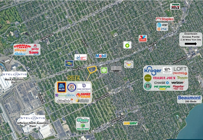


NEARBY LISTINGS FOR SALE OR LEASE
Property Detail
14630-14642 Mack Ave
21-00100-917
C B Sherrard
Stripcommercialcenter
S MACK LOTS 125 THRU 139; 277 THRU 310; 449 THRU 474 C B SHERRARD SUB L32 P58, WCR; ALSO VAC ASHLAND & MANISTIQUE AVES (60 FT WD) & VAC ALLEYS ADJ ALL DES AS BEG AT SW COR MACK AVE (120 FT WD) & ALTER RD (66 FT WD); TH S 26D 18M 09S, E 274.67 FT ALG
X
Wayne
26163C0140F
Michigan
2025
4.85 AC
2025
The Pointes/Harper Woods
512800
Detroit
60,484 SF
Detroit-Warren-Dearborn, MI
DEMOGRAPHICS near 14630-14642 Mack Ave
1 Mile
3 Mile
5 Mile
2024 Total Population
16,592
114,230
237,557
2029 Population
16,696
114,287
237,247
Pop Growth 2024-2029
+ 0.63%
+ 0.05%
(0.13%)
Average Age
38
39
39
2024 Total Households
6,518
44,094
93,576
HH Growth 2024-2029
+ 0.68%
(0.08%)
(0.29%)
Median Household Inc
$38,844
$43,945
$44,786
Avg Household Size
2.40
2.50
2.40
2024 Avg HH Vehicles
1.00
1.00
1.00
Median Home Value
$160,521
$138,934
$123,053
Median Year Built
1947
1948
1950
Nearby Places
Map Layers
Map Styles
 Street
 Aerial
- Restaurants
- Banks
- Shops
- Fitness
- Groceries
PUBLIC TRANSPORTATION
AIRPORT
Detroit City
DRIVE
WALK
Distance
Detroit City
16 min
6.6 mi
Detroit Metro Wayne County
DRIVE
WALK
Distance
Detroit Metro Wayne County
40 min
31.0 mi
Freight Ports
Port of Baltimore
DRIVE
WALK
Distance
Port of Baltimore
1 min
395.8 mi
SALE & LEASE HISTORY
LISTING DATE
SALE/LEASE

Jan 19, 2023
For Lease
Aug 02, 2024
For Lease
Nearby Properties
Address
Land Use
TOTAL SIZE
Lot Size
Zoning
Address
Land Use
TOTAL SIZE
Lot Size
Zoning
2,958,207 SF
277.38 AC
M4
Address
Land Use
TOTAL SIZE
Lot Size
Zoning
2,005,073 SF
108.66 AC
M4
Address
Land Use
TOTAL SIZE
Lot Size
Zoning
461,840 SF
4.78 AC
R6
Address
Land Use
TOTAL SIZE
Lot Size
Zoning
929,400 SF
52.48 AC
M4
Address
Land Use
TOTAL SIZE
Lot Size
Zoning
482,649 SF
M4
Address
Land Use
TOTAL SIZE
Lot Size
Zoning
648,928 SF
5.46 AC
R6
Address
Land Use
TOTAL SIZE
Lot Size
Zoning
575,081 SF
8.53 AC
R6
Address
Land Use
TOTAL SIZE
Lot Size
Zoning
298,117 SF
15.97 AC
PD
Address
Land Use
TOTAL SIZE
Lot Size
Zoning
49,437 SF
0.47 AC
Address
Land Use
TOTAL SIZE
Lot Size
Zoning
57.16 AC
M4
Address
Land Use
TOTAL SIZE
Lot Size
Zoning
93,296 SF
1.05 AC
C-2
Address
Land Use
TOTAL SIZE
Lot Size
Zoning
358,327 SF
M4
Address
Land Use
TOTAL SIZE
Lot Size
Zoning
62,195 SF
1.50 AC
Address
Land Use
TOTAL SIZE
Lot Size
Zoning
302,305 SF
M4
Address
Land Use
TOTAL SIZE
Lot Size
Zoning
17,558 SF
3.15 AC
Address
Land Use
TOTAL SIZE
Lot Size
Zoning
41,000 SF
C-1
Address
Land Use
TOTAL SIZE
Lot Size
Zoning
89,897 SF
2.23 AC
Address
Land Use
TOTAL SIZE
Lot Size
Zoning
129,260 SF
3 AC
B4
Address
Land Use
TOTAL SIZE
Lot Size
Zoning
72,940 SF
83.37 AC
M4
Address
Land Use
TOTAL SIZE
Lot Size
Zoning
93,850 SF
6.56 AC
Address
Land Use
TOTAL SIZE
Lot Size
Zoning
88,695 SF
6.53 AC
PD
Address
Land Use
TOTAL SIZE
Lot Size
Zoning
115,839 SF
8.54 AC
M4
Address
Land Use
TOTAL SIZE
Lot Size
Zoning
28,055 SF
0.44 AC
Address
Land Use
TOTAL SIZE
Lot Size
Zoning
105,847 SF
2.28 AC
R5
Address
Land Use
TOTAL SIZE
Lot Size
Zoning
62,402 SF
0.28 AC
B4
Address
Land Use
TOTAL SIZE
Lot Size
Zoning
42,113 SF
0.54 AC
Address
Land Use
TOTAL SIZE
Lot Size
Zoning
24,826 SF
5.56 AC
B4
Address
Land Use
TOTAL SIZE
Lot Size
Zoning
77,196 SF
21.21 AC
M3
Address
Land Use
TOTAL SIZE
Lot Size
Zoning
20,625 SF
0.48 AC
C-2
Address
Land Use
TOTAL SIZE
Lot Size
Zoning
60,638 SF
0.27 AC
B4
The World's #1 Commercial Real Estate Marketplace
Connect with us
© 2025 CoStar Group
The information above has been obtained from sources believed reliable. While we do not doubt its accuracy we have not verified it and make no guarantee, warranty or representation about it. It is your responsibility to independently confirm its accuracy and completeness. Any projections, opinions, assumptions, or estimates used are for example only and do not represent the current or future performance of the property. The value of this transaction to you depends on tax and other factors which should be evaluated by your tax, financial, and legal advisors. You and your advisors should conduct a careful, independent investigation of the property to determine to your satisfaction the suitability of the property for your needs.