Property Record
14640 W Shields Ave, Kerman, CA 93630
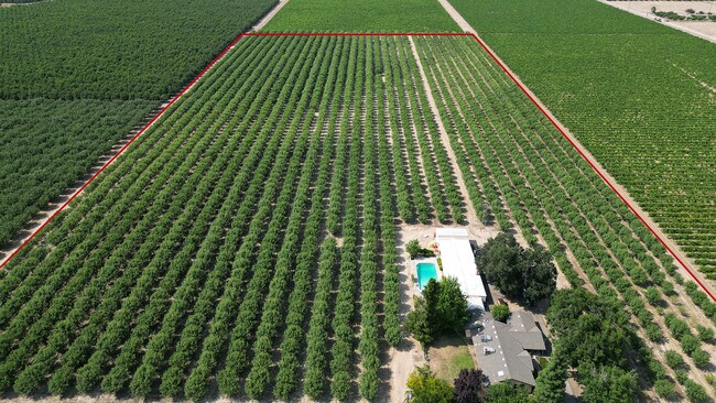


Property Detail
14640 W Shields Ave
016-340-11
20 ACS LOT 75 BANK OF CALIFORNIA TRACT
Orchard
FRESNO
AE20
California
B and X Area of moderate flood hazard, usually the area between the limits of the 100-year and 500-year floods.
75
2025
20 AC
2025
W Outlying Fresno County
004100
Fresno
2,578 SF
Fresno, CA
NEARBY LISTINGS FOR SALE OR LEASE
-
-
View all Kerman listings for sale on LoopNet.com
DEMOGRAPHICS near 14640 W Shields Ave
1 mile
3 mile
5 mile
2024 Total Population
227
2,503
21,624
2029 Population
218
2,387
21,855
Pop Growth 2024-2029
(3.96%)
(4.63%)
+ 1.07%
Average Age
39
36
35
2024 Total Households
70
700
6,043
HH Growth 2024-2029
(4.29%)
(4.57%)
+ 1.06%
Median Household Inc
$93,749
$53,762
$59,344
Avg Household Size
3.20
3.40
3.60
2024 Avg HH Vehicles
2.00
2.00
2.00
Median Home Value
$494,444
$391,208
$381,350
Median Year Built
1972
1991
1992
Nearby Places
Map Layers
Map Styles
 Street
 Aerial
Transit
 Traffic
 Biking
Places
Listings with unknown addresses are not visible on the map
- Restaurants
- Banks
- Shops
- Fitness
- Groceries
PUBLIC TRANSPORTATION
AIRPORT
Fresno Yosemite International
Drive
Walk
Distance
Fresno Yosemite International
34 min
23.9 mi
Freight Ports
Port of Stockton
Drive
Walk
Distance
Port of Stockton
145 min
118.4 mi
SALE & LEASE HISTORY
LISTING DATE
SALE/LEASE

Jun 14, 2023
For Sale
Nearby Properties
Address
Land Use
TOTAL SIZE
Lot Size
Zoning
Address
Land Use
TOTAL SIZE
Lot Size
Zoning
44,635 SF
8.10 AC
M3
Address
Land Use
TOTAL SIZE
Lot Size
Zoning
11,107 SF
3.92 AC
M1
Address
Land Use
TOTAL SIZE
Lot Size
Zoning
8,800 SF
16.12 AC
AE20
Address
Land Use
TOTAL SIZE
Lot Size
Zoning
90,082 SF
9.12 AC
C2
Address
Land Use
TOTAL SIZE
Lot Size
Zoning
1,125 SF
27.40 AC
AE20
Address
Land Use
TOTAL SIZE
Lot Size
Zoning
2,036 SF
317.51 AC
AE20
Address
Land Use
TOTAL SIZE
Lot Size
Zoning
69,820 SF
19.72 AC
Address
Land Use
TOTAL SIZE
Lot Size
Zoning
51,268 SF
4.83 AC
R2
Address
Land Use
TOTAL SIZE
Lot Size
Zoning
1,720 SF
20 AC
AE20
Address
Land Use
TOTAL SIZE
Lot Size
Zoning
14,375 SF
19.72 AC
AE20
Address
Land Use
TOTAL SIZE
Lot Size
Zoning
103,686 SF
9.30 AC
AE20
Address
Land Use
TOTAL SIZE
Lot Size
Zoning
6,898 SF
38.48 AC
AE20
Address
Land Use
TOTAL SIZE
Lot Size
Zoning
19,584 SF
2.77 AC
Address
Land Use
TOTAL SIZE
Lot Size
Zoning
28.92 AC
Address
Land Use
TOTAL SIZE
Lot Size
Zoning
810 SF
40 AC
AE20
Address
Land Use
TOTAL SIZE
Lot Size
Zoning
10,748 SF
1.22 AC
AL20
Address
Land Use
TOTAL SIZE
Lot Size
Zoning
5,468 SF
5 AC
Address
Land Use
TOTAL SIZE
Lot Size
Zoning
1,954 SF
51.26 AC
AE20
Address
Land Use
TOTAL SIZE
Lot Size
Zoning
1,977 SF
40 AC
AE20
Address
Land Use
TOTAL SIZE
Lot Size
Zoning
54.33 AC
5433
Address
Land Use
TOTAL SIZE
Lot Size
Zoning
7,020 SF
20 AC
AL20
Address
Land Use
TOTAL SIZE
Lot Size
Zoning
26,036 SF
30 AC
AE20
Address
Land Use
TOTAL SIZE
Lot Size
Zoning
1,240 SF
40 AC
AE20
Address
Land Use
TOTAL SIZE
Lot Size
Zoning
1,056 SF
50.04 AC
AE20
Address
Land Use
TOTAL SIZE
Lot Size
Zoning
2,172 SF
52.14 AC
ARE-20
Address
Land Use
TOTAL SIZE
Lot Size
Zoning
76.84 AC
AE20
Address
Land Use
TOTAL SIZE
Lot Size
Zoning
1,676 SF
140 AC
AE20
Address
Land Use
TOTAL SIZE
Lot Size
Zoning
1,831 SF
40 AC
AE20
Address
Land Use
TOTAL SIZE
Lot Size
Zoning
1,318 SF
51.23 AC
AE20
The World's #1 Commercial Real Estate Marketplace
Connect with us
© 2026 CoStar Group
The information above has been obtained from sources believed reliable. While we do not doubt its accuracy we have not verified it and make no guarantee, warranty or representation about it. It is your responsibility to independently confirm its accuracy and completeness. Any projections, opinions, assumptions, or estimates used are for example only and do not represent the current or future performance of the property. The value of this transaction to you depends on tax and other factors which should be evaluated by your tax, financial, and legal advisors. You and your advisors should conduct a careful, independent investigation of the property to determine to your satisfaction the suitability of the property for your needs.