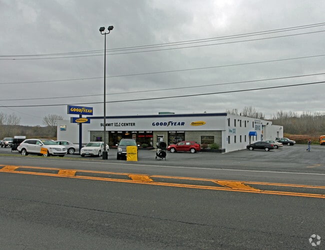
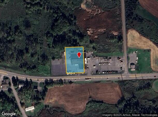
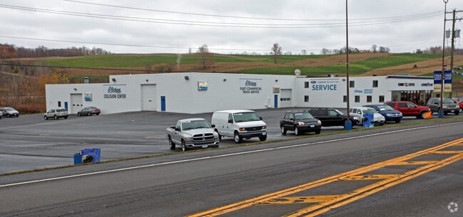
Property Record
1465 State Route 5, Elbridge, NY 13060

NEARBY LISTINGS FOR SALE OR LEASE
-
-
View all Elbridge listings for sale on LoopNet.com
Property Detail
1465 State Route 5
312889-037-000-0001-018-000-0000
Onondaga
Vehiclerentalsvehiclesales
New York
X
18.000
36067C0170F
1.31 AC
2025
W Outer Onondaga County
2024
Syracuse
012000
Syracuse, NY
26,298 SF
DEMOGRAPHICS near 1465 State Route 5
1 Mile
3 Mile
5 Mile
2024 Total Population
825
3,201
14,761
2029 Population
817
3,127
14,452
Pop Growth 2024-2029
(0.97%)
(2.31%)
(2.09%)
Average Age
43
45
45
2024 Total Households
320
1,305
6,110
HH Growth 2024-2029
(1.25%)
(2.68%)
(2.29%)
Median Household Inc
$40,060
$53,761
$73,444
Avg Household Size
2.30
2.30
2.40
2024 Avg HH Vehicles
2.00
2.00
2.00
Median Home Value
$91,303
$182,876
$208,037
Median Year Built
1982
1976
1969
Nearby Places
Map Layers
Map Styles
 Street
 Aerial
- Restaurants
- Banks
- Shops
- Fitness
- Groceries
PUBLIC TRANSPORTATION
AIRPORT
Syracuse Hancock International
DRIVE
WALK
Distance
Syracuse Hancock International
30 min
20.4 mi
Nearby Properties
Address
Land Use
TOTAL SIZE
Lot Size
Zoning
Address
Land Use
TOTAL SIZE
Lot Size
Zoning
4,200 SF
51.92 AC
06 - INDUS
Address
Land Use
TOTAL SIZE
Lot Size
Zoning
208 SF
46.88 AC
02 - SINGL
Address
Land Use
TOTAL SIZE
Lot Size
Zoning
52,922 SF
16.06 AC
07 - MIXED
Address
Land Use
TOTAL SIZE
Lot Size
Zoning
Address
Land Use
TOTAL SIZE
Lot Size
Zoning
10,004 SF
4.03 AC
02 - SINGL
Address
Land Use
TOTAL SIZE
Lot Size
Zoning
20,252 SF
9.66 AC
02
Address
Land Use
TOTAL SIZE
Lot Size
Zoning
5,740 SF
2.36 AC
05 - COMME
Address
Land Use
TOTAL SIZE
Lot Size
Zoning
924 SF
11.39 AC
05 - COMME
Address
Land Use
TOTAL SIZE
Lot Size
Zoning
Address
Land Use
TOTAL SIZE
Lot Size
Zoning
92.89 AC
04 - FARM
Address
Land Use
TOTAL SIZE
Lot Size
Zoning
5,440 SF
10.45 AC
06 - INDUS
Address
Land Use
TOTAL SIZE
Lot Size
Zoning
6,318 SF
207.46 AC
07 - MIXED
Address
Land Use
TOTAL SIZE
Lot Size
Zoning
10,976 SF
2.14 AC
05 - COMME
Address
Land Use
TOTAL SIZE
Lot Size
Zoning
2,848 SF
1.10 AC
07 - MIXED
Address
Land Use
TOTAL SIZE
Lot Size
Zoning
25,831 SF
8.31 AC
07 - MIXED
Address
Land Use
TOTAL SIZE
Lot Size
Zoning
8,490 SF
47.04 AC
02 - SINGL
Address
Land Use
TOTAL SIZE
Lot Size
Zoning
9,100 SF
1.11 AC
05 - COMME
Address
Land Use
TOTAL SIZE
Lot Size
Zoning
900 SF
0.46 AC
08 - GOVER
Address
Land Use
TOTAL SIZE
Lot Size
Zoning
Address
Land Use
TOTAL SIZE
Lot Size
Zoning
11,700 SF
1.66 AC
05 - COMME
Address
Land Use
TOTAL SIZE
Lot Size
Zoning
22.01 AC
Address
Land Use
TOTAL SIZE
Lot Size
Zoning
6,044 SF
2.42 AC
01 - NOT Z
Address
Land Use
TOTAL SIZE
Lot Size
Zoning
02 - SINGL
Address
Land Use
TOTAL SIZE
Lot Size
Zoning
16,865 SF
6.31 AC
05 - COMME
Address
Land Use
TOTAL SIZE
Lot Size
Zoning
Address
Land Use
TOTAL SIZE
Lot Size
Zoning
10,910 SF
1.07 AC
05 - COMME
Address
Land Use
TOTAL SIZE
Lot Size
Zoning
7,400 SF
126.42 AC
04 - FARM
Address
Land Use
TOTAL SIZE
Lot Size
Zoning
7,842 SF
1.63 AC
03 - MULTI
Address
Land Use
TOTAL SIZE
Lot Size
Zoning
3,780 SF
2.28 AC
04 - FARM
The World's #1 Commercial Real Estate Marketplace
Connect with us
© 2026 CoStar Group
The information above has been obtained from sources believed reliable. While we do not doubt its accuracy we have not verified it and make no guarantee, warranty or representation about it. It is your responsibility to independently confirm its accuracy and completeness. Any projections, opinions, assumptions, or estimates used are for example only and do not represent the current or future performance of the property. The value of this transaction to you depends on tax and other factors which should be evaluated by your tax, financial, and legal advisors. You and your advisors should conduct a careful, independent investigation of the property to determine to your satisfaction the suitability of the property for your needs.