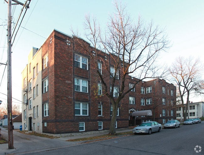
Property Record
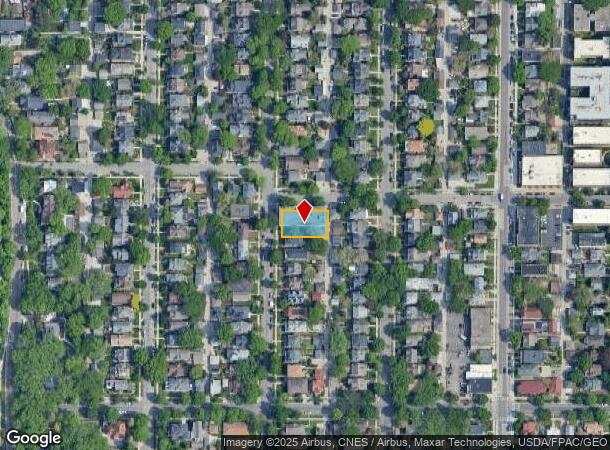
1465 W 33Rd St, Minneapolis, MN 55408
NEARBY LISTINGS FOR SALE OR LEASE
Property Detail
1465 W 33Rd St
Minneapolis-St. Paul-Bloomington, MN-WI
Calhoun Park
04-028-24-24-0141
LOT 013 BLOCK 047 A CALHOUN PARK LOTS 13 AND 14 129.00 X 72.00
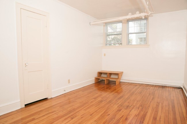
Apartment
Hennepin
X
Minnesota
27053C0358F
13
2024
0.21 AC
2024
East Calhoun
108000
Minneapolis/St Paul
17,700 SF
DEMOGRAPHICS near 1465 W 33Rd St
1 Mile
3 Mile
5 Mile
2024 Total Population
27,006
217,744
486,446
2029 Population
26,678
214,643
479,385
Pop Growth 2024-2029
(1.21%)
(1.42%)
(1.45%)
Average Age
36
38
38
2024 Total Households
14,858
101,506
216,248
HH Growth 2024-2029
(1.27%)
(1.31%)
(1.38%)
Median Household Inc
$73,021
$74,031
$74,667
Avg Household Size
1.80
2.00
2.10
2024 Avg HH Vehicles
1.00
1.00
1.00
Median Home Value
$447,585
$396,001
$362,543
Median Year Built
1956
1952
1958
Nearby Places
Map Layers
Map Styles
 Street
 Aerial
- Restaurants
- Banks
- Shops
- Fitness
- Groceries
PUBLIC TRANSPORTATION
COMMUTER RAIL
Target Field Station (Northstar Corridor - Northstar Commuter Rail)
DRIVE
WALK
Distance
Target Field Station (Northstar Corridor - Northstar Commuter Rail)
12 min
4.1 mi
AIRPORT
Minneapolis-St Paul International/Wold-Chamberlain
DRIVE
WALK
Distance
Minneapolis-St Paul International/Wold-Chamberlain
22 min
11.5 mi
Nearby Properties
Address
Land Use
TOTAL SIZE
Lot Size
Zoning
Address
Land Use
TOTAL SIZE
Lot Size
Zoning
1,462,182 SF
1 AC
B4-2
Address
Land Use
TOTAL SIZE
Lot Size
Zoning
2,094,377 SF
2.10 AC
B4-2
Address
Land Use
TOTAL SIZE
Lot Size
Zoning
1,821,999 SF
2.51 AC
B4-2
Address
Land Use
TOTAL SIZE
Lot Size
Zoning
1,934,403 SF
1.67 AC
B4-2
Address
Land Use
TOTAL SIZE
Lot Size
Zoning
2,282,334 SF
3.25 AC
B4-2
Address
Land Use
TOTAL SIZE
Lot Size
Zoning
1,208,190 SF
1.20 AC
B4-2
Address
Land Use
TOTAL SIZE
Lot Size
Zoning
621,608 SF
1.03 AC
B4-2
Address
Land Use
TOTAL SIZE
Lot Size
Zoning
458,470 SF
1.18 AC
OR3
Address
Land Use
TOTAL SIZE
Lot Size
Zoning
907,129 SF
1.65 AC
B4-1
Address
Land Use
TOTAL SIZE
Lot Size
Zoning
Address
Land Use
TOTAL SIZE
Lot Size
Zoning
1,044,454 SF
1.08 AC
B4-2
Address
Land Use
TOTAL SIZE
Lot Size
Zoning
1,261,574 SF
2.52 AC
B4-2
Address
Land Use
TOTAL SIZE
Lot Size
Zoning
275,782 SF
2.40 AC
C3A
Address
Land Use
TOTAL SIZE
Lot Size
Zoning
659,076 SF
1.45 AC
C3A
Address
Land Use
TOTAL SIZE
Lot Size
Zoning
722,423 SF
1.33 AC
B4-2
Address
Land Use
TOTAL SIZE
Lot Size
Zoning
1,424,796 SF
1.13 AC
B4-1
Address
Land Use
TOTAL SIZE
Lot Size
Zoning
3,008,334 SF
7.72 AC
Address
Land Use
TOTAL SIZE
Lot Size
Zoning
Address
Land Use
TOTAL SIZE
Lot Size
Zoning
1,235,416 SF
1.12 AC
B4-2
Address
Land Use
TOTAL SIZE
Lot Size
Zoning
1.50 AC
Address
Land Use
TOTAL SIZE
Lot Size
Zoning
561,603 SF
1 AC
B4N
Address
Land Use
TOTAL SIZE
Lot Size
Zoning
Address
Land Use
TOTAL SIZE
Lot Size
Zoning
832,819 SF
0.64 AC
B4-2
Address
Land Use
TOTAL SIZE
Lot Size
Zoning
439,615 SF
1.23 AC
B4-2
Address
Land Use
TOTAL SIZE
Lot Size
Zoning
2,207,532 SF
11.15 AC
Address
Land Use
TOTAL SIZE
Lot Size
Zoning
924,152 SF
2.50 AC
B4-2
Address
Land Use
TOTAL SIZE
Lot Size
Zoning
398,356 SF
1.14 AC
B4N
Address
Land Use
TOTAL SIZE
Lot Size
Zoning
4,497,396 SF
11.05 AC
Address
Land Use
TOTAL SIZE
Lot Size
Zoning
264,176 SF
1.61 AC
OR2
Address
Land Use
TOTAL SIZE
Lot Size
Zoning
573,174 SF
1.51 AC
B4-2
The World's #1 Commercial Real Estate Marketplace
Connect with us
© 2025 CoStar Group
The information above has been obtained from sources believed reliable. While we do not doubt its accuracy we have not verified it and make no guarantee, warranty or representation about it. It is your responsibility to independently confirm its accuracy and completeness. Any projections, opinions, assumptions, or estimates used are for example only and do not represent the current or future performance of the property. The value of this transaction to you depends on tax and other factors which should be evaluated by your tax, financial, and legal advisors. You and your advisors should conduct a careful, independent investigation of the property to determine to your satisfaction the suitability of the property for your needs.