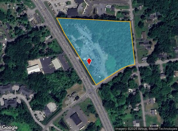
Property Record
1467 Route 9, Halfmoon, NY 12065

NEARBY LISTINGS FOR SALE OR LEASE
Property Detail
1467 Route 9
Albany-Schenectady-Troy, NY
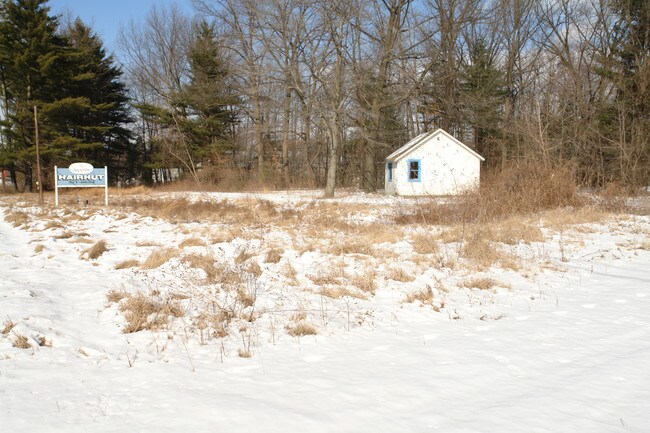
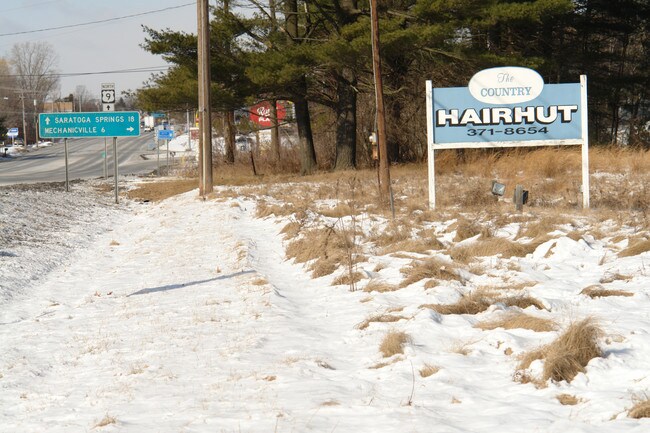
COUNTRY HAIR HUT LAND/BLDG
413800-278-004-0002-042-000-0000
Saratoga
Storesoffices
New York
2025
42.000
2024
7.30 AC
062408
Saratoga County
304 SF
Albany/Schenectady/Troy
DEMOGRAPHICS near 1467 Route 9
1 Mile
3 Mile
5 Mile
2024 Total Population
5,078
29,276
82,918
2029 Population
5,160
29,849
83,656
Pop Growth 2024-2029
+ 1.61%
+ 1.96%
+ 0.89%
Average Age
44
42
42
2024 Total Households
2,414
12,645
35,501
HH Growth 2024-2029
+ 1.74%
+ 1.89%
+ 0.74%
Median Household Inc
$99,130
$94,100
$86,202
Avg Household Size
2.10
2.30
2.30
2024 Avg HH Vehicles
2.00
2.00
2.00
Median Home Value
$248,042
$283,435
$284,155
Median Year Built
1986
1985
1978
Nearby Places
- Restaurants
- Banks
- Shops
- Fitness
- Groceries
PUBLIC TRANSPORTATION
AIRPORT
Albany International
DRIVE
WALK
Distance
Albany International
14 min
8.5 mi
Freight Ports
Albany, NY Port
DRIVE
WALK
Distance
Albany, NY Port
27 min
17.9 mi
Nearby Properties
Address
Land Use
TOTAL SIZE
Lot Size
Zoning
Address
Land Use
TOTAL SIZE
Lot Size
Zoning
2,655 SF
47.22 AC
07 - MIXED
Address
Land Use
TOTAL SIZE
Lot Size
Zoning
20,444 SF
40.95 AC
02 - SINGL
Address
Land Use
TOTAL SIZE
Lot Size
Zoning
5,091 SF
33.35 AC
02 - SINGL
Address
Land Use
TOTAL SIZE
Lot Size
Zoning
4,680 SF
26.74 AC
Address
Land Use
TOTAL SIZE
Lot Size
Zoning
12,234 SF
32 AC
05 - COMME
Address
Land Use
TOTAL SIZE
Lot Size
Zoning
12,294 SF
36.70 AC
03 - MULTI
Address
Land Use
TOTAL SIZE
Lot Size
Zoning
109,323 SF
45.52 AC
05 - COMME
Address
Land Use
TOTAL SIZE
Lot Size
Zoning
183,632 SF
20.82 AC
05 - COMME
Address
Land Use
TOTAL SIZE
Lot Size
Zoning
195,069 SF
28.40 AC
07 - MIXED
Address
Land Use
TOTAL SIZE
Lot Size
Zoning
125,739 SF
20.02 AC
05 - COMME
Address
Land Use
TOTAL SIZE
Lot Size
Zoning
22,401 SF
9.69 AC
25
Address
Land Use
TOTAL SIZE
Lot Size
Zoning
147,200 SF
0.89 AC
05 - COMME
Address
Land Use
TOTAL SIZE
Lot Size
Zoning
159,571 SF
22.89 AC
05 - COMME
Address
Land Use
TOTAL SIZE
Lot Size
Zoning
23,402 SF
5.84 AC
25
Address
Land Use
TOTAL SIZE
Lot Size
Zoning
15,727 SF
11.27 AC
04 - FARM
Address
Land Use
TOTAL SIZE
Lot Size
Zoning
15,435 SF
23.68 AC
04 - FARM
Address
Land Use
TOTAL SIZE
Lot Size
Zoning
100 SF
173.60 AC
04 - FARM
Address
Land Use
TOTAL SIZE
Lot Size
Zoning
134,095 SF
15.39 AC
05 - COMME
Address
Land Use
TOTAL SIZE
Lot Size
Zoning
38,110 SF
7.01 AC
05 - COMME
Address
Land Use
TOTAL SIZE
Lot Size
Zoning
88,110 SF
11.52 AC
05 - COMME
Address
Land Use
TOTAL SIZE
Lot Size
Zoning
120,645 SF
17.43 AC
15
Address
Land Use
TOTAL SIZE
Lot Size
Zoning
34,234 SF
17.27 AC
07 - MIXED
Address
Land Use
TOTAL SIZE
Lot Size
Zoning
95,800 SF
23.50 AC
Address
Land Use
TOTAL SIZE
Lot Size
Zoning
1,440 SF
0.34 AC
05 - COMME
Address
Land Use
TOTAL SIZE
Lot Size
Zoning
116,325 SF
13.41 AC
07 - MIXED
Address
Land Use
TOTAL SIZE
Lot Size
Zoning
95,175 SF
10.75 AC
05 - COMME
Address
Land Use
TOTAL SIZE
Lot Size
Zoning
73,000 SF
2.55 AC
05 - COMME
Address
Land Use
TOTAL SIZE
Lot Size
Zoning
3,840 SF
9.15 AC
02 - SINGL
Address
Land Use
TOTAL SIZE
Lot Size
Zoning
81,200 SF
2.90 AC
05 - COMME
Address
Land Use
TOTAL SIZE
Lot Size
Zoning
87,016 SF
0.81 AC
05 - COMME
The World's #1 Commercial Real Estate Marketplace
Connect with us
© 2025 CoStar Group
The information above has been obtained from sources believed reliable. While we do not doubt its accuracy we have not verified it and make no guarantee, warranty or representation about it. It is your responsibility to independently confirm its accuracy and completeness. Any projections, opinions, assumptions, or estimates used are for example only and do not represent the current or future performance of the property. The value of this transaction to you depends on tax and other factors which should be evaluated by your tax, financial, and legal advisors. You and your advisors should conduct a careful, independent investigation of the property to determine to your satisfaction the suitability of the property for your needs.