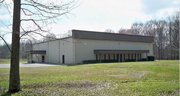
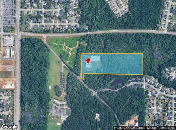
Property Record
1469 Browns Ferry Rd, Madison, AL 35758
NEARBY LISTINGS FOR SALE OR LEASE
-
-
View all Madison listings for sale on LoopNet.com
Property Detail
1469 Browns Ferry Rd
Huntsville, AL
Tall Oaks
16-03-06-0-001-012.000
TRACT 2 TALL OAKS S/D PB 19 PG 22
Religious
Madison
AE
Alabama
01089C0282E
2
0
13.72 AC
2025
Jetplex/Madison
011024
Huntsville
10,000 SF
DEMOGRAPHICS near 1469 Browns Ferry Rd
1 Mile
3 Mile
5 Mile
2024 Total Population
6,319
49,397
93,689
2029 Population
7,057
55,736
105,557
Pop Growth 2024-2029
+ 11.68%
+ 12.83%
+ 12.67%
Average Age
38
38
39
2024 Total Households
2,012
17,638
35,998
HH Growth 2024-2029
+ 12.23%
+ 13.22%
+ 12.98%
Median Household Inc
$145,187
$114,340
$104,314
Avg Household Size
3.10
2.80
2.60
2024 Avg HH Vehicles
2.00
2.00
2.00
Median Home Value
$356,949
$313,884
$293,519
Median Year Built
2004
2002
2001
Nearby Places
Map Layers
Map Styles
 Street
 Aerial
- Restaurants
- Banks
- Shops
- Fitness
- Groceries
PUBLIC TRANSPORTATION
AIRPORT
Huntsville International-Carl T Jones Field
DRIVE
WALK
Distance
Huntsville International-Carl T Jones Field
17 min
8.7 mi
Freight Ports
Port of Mobile
DRIVE
WALK
Distance
Port of Mobile
384 min
347.7 mi
Nearby Properties
Address
Land Use
TOTAL SIZE
Lot Size
Zoning
Address
Land Use
TOTAL SIZE
Lot Size
Zoning
25,692 SF
11.77 AC
Address
Land Use
TOTAL SIZE
Lot Size
Zoning
5,487 SF
30 AC
Address
Land Use
TOTAL SIZE
Lot Size
Zoning
7,055 SF
19 AC
Address
Land Use
TOTAL SIZE
Lot Size
Zoning
3,746 SF
22.08 AC
Address
Land Use
TOTAL SIZE
Lot Size
Zoning
8,868 SF
25 AC
Address
Land Use
TOTAL SIZE
Lot Size
Zoning
3,772 SF
31 AC
Address
Land Use
TOTAL SIZE
Lot Size
Zoning
9,138 SF
27 AC
Address
Land Use
TOTAL SIZE
Lot Size
Zoning
2,774 SF
16 AC
Address
Land Use
TOTAL SIZE
Lot Size
Zoning
87.59 AC
Address
Land Use
TOTAL SIZE
Lot Size
Zoning
8,468 SF
5.80 AC
Address
Land Use
TOTAL SIZE
Lot Size
Zoning
4,644 SF
20.70 AC
Address
Land Use
TOTAL SIZE
Lot Size
Zoning
8,096 SF
7.15 AC
Address
Land Use
TOTAL SIZE
Lot Size
Zoning
9,808 SF
35.84 AC
Address
Land Use
TOTAL SIZE
Lot Size
Zoning
49,380 SF
6.18 AC
Address
Land Use
TOTAL SIZE
Lot Size
Zoning
5,600 SF
17.16 AC
Address
Land Use
TOTAL SIZE
Lot Size
Zoning
86,280 SF
18.90 AC
Address
Land Use
TOTAL SIZE
Lot Size
Zoning
38,047 SF
7 AC
Address
Land Use
TOTAL SIZE
Lot Size
Zoning
22,171 SF
Address
Land Use
TOTAL SIZE
Lot Size
Zoning
178,255 SF
19.39 AC
Address
Land Use
TOTAL SIZE
Lot Size
Zoning
39,385 SF
4.52 AC
Address
Land Use
TOTAL SIZE
Lot Size
Zoning
4.55 AC
Address
Land Use
TOTAL SIZE
Lot Size
Zoning
138,920 SF
9.53 AC
Address
Land Use
TOTAL SIZE
Lot Size
Zoning
12,510 SF
2.76 AC
Address
Land Use
TOTAL SIZE
Lot Size
Zoning
39,060 SF
4.77 AC
Address
Land Use
TOTAL SIZE
Lot Size
Zoning
516 SF
12.13 AC
Address
Land Use
TOTAL SIZE
Lot Size
Zoning
48,200 SF
4.05 AC
Address
Land Use
TOTAL SIZE
Lot Size
Zoning
21,084 SF
10.06 AC
Address
Land Use
TOTAL SIZE
Lot Size
Zoning
10,160 SF
3.13 AC
Address
Land Use
TOTAL SIZE
Lot Size
Zoning
6,170 SF
3.98 AC
Address
Land Use
TOTAL SIZE
Lot Size
Zoning
136,218 SF
16.36 AC
The World's #1 Commercial Real Estate Marketplace
Connect with us
© 2025 CoStar Group
The information above has been obtained from sources believed reliable. While we do not doubt its accuracy we have not verified it and make no guarantee, warranty or representation about it. It is your responsibility to independently confirm its accuracy and completeness. Any projections, opinions, assumptions, or estimates used are for example only and do not represent the current or future performance of the property. The value of this transaction to you depends on tax and other factors which should be evaluated by your tax, financial, and legal advisors. You and your advisors should conduct a careful, independent investigation of the property to determine to your satisfaction the suitability of the property for your needs.