Property Record
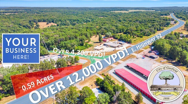
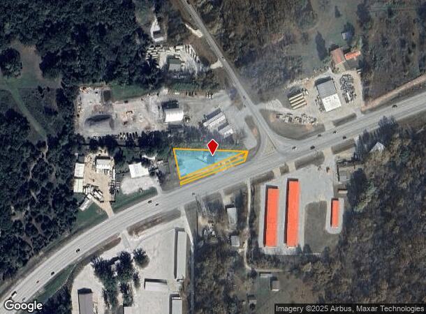
14696 E Us 62 Hwy, Rogers, AR 72756
NEARBY LISTINGS FOR SALE OR LEASE
-
-
View all Rogers listings for sale on LoopNet.com
Property Detail
14696 E Us 62 Hwy
18-04270-001
Rural
Officebuilding
PART OF THE SE 1/4 OF THE SW1/4, OF SECTION 3, TOWNSHIP 20 NORTH, RANGE 29 WEST, BENTON COUNTY, ARKANSAS, MORE PARTICULARLY DESCRIBED AS FOLLOWS: FROM THE NW CORNER OF SAID SE1/4 OF THE SW1/4; THENCE SOUTH 87 5420 EAST 427.8 FEET, THENCE SOUTH 10 FEE
X
Benton
29119C0475D
Arkansas
2025
0.59 AC
2025
Outlying Benton County
020203
Fayetteville/Springdale/Rogers
2,244 SF
Fayetteville-Springdale-Rogers, AR-MO
DEMOGRAPHICS near 14696 E Us 62 Hwy
1 Mile
3 Mile
5 Mile
2024 Total Population
420
3,553
17,084
2029 Population
495
4,214
20,273
Pop Growth 2024-2029
+ 17.86%
+ 18.60%
+ 18.67%
Average Age
41
40
39
2024 Total Households
154
1,254
6,028
HH Growth 2024-2029
+ 18.18%
+ 18.66%
+ 18.68%
Median Household Inc
$71,911
$69,386
$78,755
Avg Household Size
2.70
2.80
2.80
2024 Avg HH Vehicles
3.00
3.00
2.00
Median Home Value
$192,104
$231,417
$229,673
Median Year Built
1990
1993
1994
Nearby Places
Map Layers
Map Styles
 Street
 Aerial
- Restaurants
- Banks
- Shops
- Fitness
- Groceries
PUBLIC TRANSPORTATION
AIRPORT
Northwest Arkansas Ntl
DRIVE
WALK
Distance
Northwest Arkansas Ntl
41 min
22.6 mi
Freight Ports
Tulsa Port of Inola
DRIVE
WALK
Distance
Tulsa Port of Inola
127 min
107.8 mi
SALE & LEASE HISTORY
LISTING DATE
SALE/LEASE

Aug 09, 2022
For Sale
Nearby Properties
Address
Land Use
TOTAL SIZE
Lot Size
Zoning
Address
Land Use
TOTAL SIZE
Lot Size
Zoning
58,990 SF
5.70 AC
Address
Land Use
TOTAL SIZE
Lot Size
Zoning
2,027 SF
1.07 AC
Address
Land Use
TOTAL SIZE
Lot Size
Zoning
120.12 AC
Address
Land Use
TOTAL SIZE
Lot Size
Zoning
39,805 SF
6.77 AC
Address
Land Use
TOTAL SIZE
Lot Size
Zoning
4,900 SF
10.56 AC
Address
Land Use
TOTAL SIZE
Lot Size
Zoning
100 AC
Address
Land Use
TOTAL SIZE
Lot Size
Zoning
40,000 SF
4.90 AC
Address
Land Use
TOTAL SIZE
Lot Size
Zoning
57.90 AC
Address
Land Use
TOTAL SIZE
Lot Size
Zoning
17,666 SF
3.08 AC
Address
Land Use
TOTAL SIZE
Lot Size
Zoning
9,301 SF
1.13 AC
Address
Land Use
TOTAL SIZE
Lot Size
Zoning
31,884 SF
12 AC
Address
Land Use
TOTAL SIZE
Lot Size
Zoning
13,724 SF
2.05 AC
Address
Land Use
TOTAL SIZE
Lot Size
Zoning
2,490 SF
2.30 AC
Address
Land Use
TOTAL SIZE
Lot Size
Zoning
6,440 SF
3.15 AC
Address
Land Use
TOTAL SIZE
Lot Size
Zoning
931 SF
17.43 AC
Address
Land Use
TOTAL SIZE
Lot Size
Zoning
39.98 AC
Address
Land Use
TOTAL SIZE
Lot Size
Zoning
5,615 SF
0.52 AC
Address
Land Use
TOTAL SIZE
Lot Size
Zoning
39.07 AC
Address
Land Use
TOTAL SIZE
Lot Size
Zoning
5,000 SF
2.17 AC
Address
Land Use
TOTAL SIZE
Lot Size
Zoning
1,446 SF
32.50 AC
Address
Land Use
TOTAL SIZE
Lot Size
Zoning
5,735 SF
1.26 AC
Address
Land Use
TOTAL SIZE
Lot Size
Zoning
8,096 SF
1.13 AC
Address
Land Use
TOTAL SIZE
Lot Size
Zoning
7,848 SF
0.83 AC
Address
Land Use
TOTAL SIZE
Lot Size
Zoning
3,620 SF
0.73 AC
Address
Land Use
TOTAL SIZE
Lot Size
Zoning
6,000 SF
3.75 AC
Address
Land Use
TOTAL SIZE
Lot Size
Zoning
5,000 SF
1.33 AC
Address
Land Use
TOTAL SIZE
Lot Size
Zoning
575 SF
0.35 AC
Address
Land Use
TOTAL SIZE
Lot Size
Zoning
7,200 SF
2.57 AC
Address
Land Use
TOTAL SIZE
Lot Size
Zoning
5,000 SF
3 AC
Address
Land Use
TOTAL SIZE
Lot Size
Zoning
3,750 SF
1.09 AC
The World's #1 Commercial Real Estate Marketplace
Connect with us
© 2026 CoStar Group
The information above has been obtained from sources believed reliable. While we do not doubt its accuracy we have not verified it and make no guarantee, warranty or representation about it. It is your responsibility to independently confirm its accuracy and completeness. Any projections, opinions, assumptions, or estimates used are for example only and do not represent the current or future performance of the property. The value of this transaction to you depends on tax and other factors which should be evaluated by your tax, financial, and legal advisors. You and your advisors should conduct a careful, independent investigation of the property to determine to your satisfaction the suitability of the property for your needs.