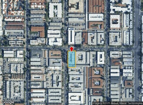
Property Record
14696 Rayen St, Panorama City, CA 91402
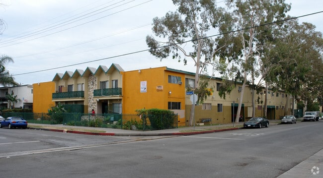
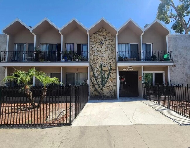

This Property Is For Sale
NEARBY LISTINGS FOR SALE OR LEASE
Property Detail
14696 Rayen St
Los Angeles-Long Beach-Glendale, CA
5638
2653-003-005
TRACT NO 5638 LOT 80
Multifamilydwelling
Los Angeles
X
California
06037C1305F
80
2024
0.53 AC
2025
North Hills East
120103
Los Angeles
19,742 SF
DEMOGRAPHICS near 14696 Rayen St
1 Mile
3 Mile
5 Mile
2024 Total Population
74,192
312,008
702,679
2029 Population
72,639
302,796
681,191
Pop Growth 2024-2029
(2.09%)
(2.95%)
(3.06%)
Average Age
36
38
38
2024 Total Households
20,111
89,245
212,511
HH Growth 2024-2029
(2.28%)
(3.06%)
(3.22%)
Median Household Inc
$51,443
$64,411
$68,151
Avg Household Size
3.60
3.30
3.10
2024 Avg HH Vehicles
2.00
2.00
2.00
Median Home Value
$554,702
$686,038
$715,981
Median Year Built
1976
1966
1965
Nearby Places
- Restaurants
- Banks
- Shops
- Fitness
- Groceries
PUBLIC TRANSPORTATION
COMMUTER RAIL
Van Nuys (Ventura County Line - Southern California Regional Rail Authority (Metrolink))
DRIVE
WALK
Distance
Van Nuys (Ventura County Line - Southern California Regional Rail Authority (Metrolink))
3 min
1.6 mi
Sylmar/San Fernando (Antelope Valley Line - Southern California Regional Rail Authority (Metrolink))
DRIVE
WALK
Distance
Sylmar/San Fernando (Antelope Valley Line - Southern California Regional Rail Authority (Metrolink))
10 min
5.4 mi
AIRPORT
Bob Hope
DRIVE
WALK
Distance
Bob Hope
13 min
7.7 mi
Los Angeles International
DRIVE
WALK
Distance
Los Angeles International
33 min
23.8 mi
Freight Ports
Port of Long Beach
DRIVE
WALK
Distance
Port of Long Beach
55 min
43.1 mi
Nearby Properties
Address
Land Use
TOTAL SIZE
Lot Size
Zoning
Address
Land Use
TOTAL SIZE
Lot Size
Zoning
393,032 SF
70.93 AC
LAM2
Address
Land Use
TOTAL SIZE
Lot Size
Zoning
838,226 SF
11.23 AC
LARA
Address
Land Use
TOTAL SIZE
Lot Size
Zoning
580,686 SF
8.46 AC
LAR1
Address
Land Use
TOTAL SIZE
Lot Size
Zoning
72,420 SF
17.08 AC
LAP
Address
Land Use
TOTAL SIZE
Lot Size
Zoning
333,677 SF
3.89 AC
LARAS3
Address
Land Use
TOTAL SIZE
Lot Size
Zoning
204,387 SF
8.46 AC
LAM2
Address
Land Use
TOTAL SIZE
Lot Size
Zoning
154,631 SF
11.62 AC
LAC2
Address
Land Use
TOTAL SIZE
Lot Size
Zoning
768,483 SF
6.87 AC
LAC1
Address
Land Use
TOTAL SIZE
Lot Size
Zoning
290,244 SF
5.77 AC
LAR3
Address
Land Use
TOTAL SIZE
Lot Size
Zoning
370,138 SF
9.84 AC
LAM2
Address
Land Use
TOTAL SIZE
Lot Size
Zoning
116,961 SF
3.60 AC
LAR3
Address
Land Use
TOTAL SIZE
Lot Size
Zoning
290,254 SF
11.53 AC
LAM2
Address
Land Use
TOTAL SIZE
Lot Size
Zoning
408,735 SF
LAC2
Address
Land Use
TOTAL SIZE
Lot Size
Zoning
160,858 SF
2.40 AC
LAR3
Address
Land Use
TOTAL SIZE
Lot Size
Zoning
138,260 SF
1.29 AC
LAC2
Address
Land Use
TOTAL SIZE
Lot Size
Zoning
417,674 SF
10.20 AC
LACM
Address
Land Use
TOTAL SIZE
Lot Size
Zoning
124,534 SF
7.47 AC
LAC2
Address
Land Use
TOTAL SIZE
Lot Size
Zoning
98,782 SF
0.66 AC
LAC2
Address
Land Use
TOTAL SIZE
Lot Size
Zoning
61,315 SF
0.84 AC
LARAS4
Address
Land Use
TOTAL SIZE
Lot Size
Zoning
211,654 SF
2.20 AC
LAM1
Address
Land Use
TOTAL SIZE
Lot Size
Zoning
180,277 SF
4.13 AC
LAM1, LAC2
Address
Land Use
TOTAL SIZE
Lot Size
Zoning
776,594 SF
16.18 AC
LAC2
Address
Land Use
TOTAL SIZE
Lot Size
Zoning
155,748 SF
1.33 AC
LAR3
Address
Land Use
TOTAL SIZE
Lot Size
Zoning
143,203 SF
1.52 AC
LAR4
Address
Land Use
TOTAL SIZE
Lot Size
Zoning
155,788 SF
4.58 AC
LAR1
Address
Land Use
TOTAL SIZE
Lot Size
Zoning
56,396 SF
0.74 AC
LARAS4
Address
Land Use
TOTAL SIZE
Lot Size
Zoning
202,218 SF
2.72 AC
LAC2
Address
Land Use
TOTAL SIZE
Lot Size
Zoning
91,192 SF
0.94 AC
LARD1.5
The World's #1 Commercial Real Estate Marketplace
Connect with us
© 2025 CoStar Group
The information above has been obtained from sources believed reliable. While we do not doubt its accuracy we have not verified it and make no guarantee, warranty or representation about it. It is your responsibility to independently confirm its accuracy and completeness. Any projections, opinions, assumptions, or estimates used are for example only and do not represent the current or future performance of the property. The value of this transaction to you depends on tax and other factors which should be evaluated by your tax, financial, and legal advisors. You and your advisors should conduct a careful, independent investigation of the property to determine to your satisfaction the suitability of the property for your needs.