Property Record
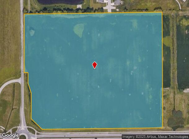
Towne Rd, Westfield, IN 46074
NEARBY LISTINGS FOR SALE OR LEASE
Property Detail
Towne Rd
29-09-16-000-015.000-015
ACREAGE 32.90, SECTION 16, TOWNSHIP 18, RANGE 3
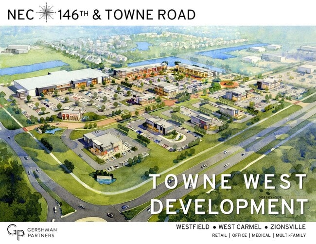
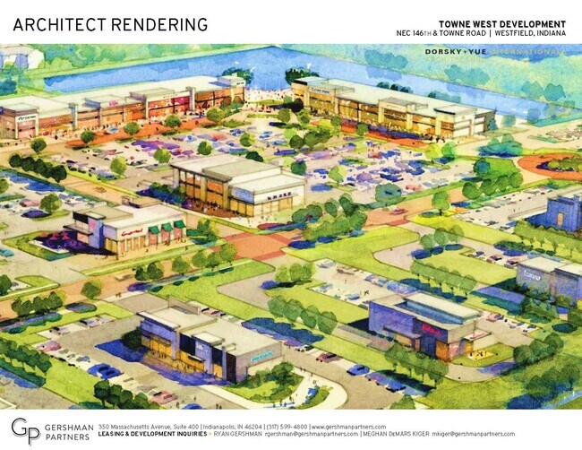
Agriculturalland
Hamilton
X
Indiana
18057C0115G
32.90 AC
2023
Carmel
2024
Indianapolis
110301
Indianapolis-Carmel-Anderson, IN
DEMOGRAPHICS near Towne Rd
1 Mile
3 Mile
5 Mile
2024 Total Population
7,010
51,037
116,839
2029 Population
8,287
57,782
132,375
Pop Growth 2024-2029
+ 18.22%
+ 13.22%
+ 13.30%
Average Age
38
38
38
2024 Total Households
2,324
16,902
43,665
HH Growth 2024-2029
+ 18.72%
+ 13.35%
+ 13.41%
Median Household Inc
$158,424
$151,478
$115,689
Avg Household Size
2.90
3.00
2.60
2024 Avg HH Vehicles
2.00
2.00
2.00
Median Home Value
$467,699
$423,545
$405,793
Median Year Built
2011
2005
2003
Nearby Places
Map Layers
Map Styles
 Street
 Aerial
- Restaurants
- Banks
- Shops
- Fitness
- Groceries
PUBLIC TRANSPORTATION
AIRPORT
Indianapolis International
DRIVE
WALK
Distance
Indianapolis International
55 min
30.0 mi
Freight Ports
Port of Toledo
DRIVE
WALK
Distance
Port of Toledo
269 min
219.8 mi
SALE & LEASE HISTORY
LISTING DATE
SALE/LEASE

Apr 02, 2021
For Lease
Nearby Properties
Address
Land Use
TOTAL SIZE
Lot Size
Zoning
Address
Land Use
TOTAL SIZE
Lot Size
Zoning
504,699 SF
40 AC
Address
Land Use
TOTAL SIZE
Lot Size
Zoning
383,016 SF
16.62 AC
Address
Land Use
TOTAL SIZE
Lot Size
Zoning
280,428 SF
12.81 AC
Address
Land Use
TOTAL SIZE
Lot Size
Zoning
402,521 SF
153.38 AC
Address
Land Use
TOTAL SIZE
Lot Size
Zoning
257,957 SF
9.06 AC
Address
Land Use
TOTAL SIZE
Lot Size
Zoning
210,424 SF
14.10 AC
Address
Land Use
TOTAL SIZE
Lot Size
Zoning
351,756 SF
8.38 AC
Address
Land Use
TOTAL SIZE
Lot Size
Zoning
145,444 SF
34.32 AC
Address
Land Use
TOTAL SIZE
Lot Size
Zoning
87,040 SF
24.23 AC
Address
Land Use
TOTAL SIZE
Lot Size
Zoning
147,081 SF
56.70 AC
Address
Land Use
TOTAL SIZE
Lot Size
Zoning
143,254 SF
9.38 AC
Address
Land Use
TOTAL SIZE
Lot Size
Zoning
188,944 SF
5.68 AC
Address
Land Use
TOTAL SIZE
Lot Size
Zoning
105,816 SF
8.59 AC
Address
Land Use
TOTAL SIZE
Lot Size
Zoning
67,111 SF
3.11 AC
Address
Land Use
TOTAL SIZE
Lot Size
Zoning
114,658 SF
12.66 AC
Address
Land Use
TOTAL SIZE
Lot Size
Zoning
60,520 SF
3.79 AC
Address
Land Use
TOTAL SIZE
Lot Size
Zoning
87,122 SF
6.25 AC
Address
Land Use
TOTAL SIZE
Lot Size
Zoning
146,976 SF
11.04 AC
Address
Land Use
TOTAL SIZE
Lot Size
Zoning
111,176 SF
30 AC
Address
Land Use
TOTAL SIZE
Lot Size
Zoning
105,544 SF
8.78 AC
Address
Land Use
TOTAL SIZE
Lot Size
Zoning
58,024 SF
2.31 AC
Address
Land Use
TOTAL SIZE
Lot Size
Zoning
41,284 SF
6.79 AC
Address
Land Use
TOTAL SIZE
Lot Size
Zoning
43,075 SF
6.14 AC
Address
Land Use
TOTAL SIZE
Lot Size
Zoning
82,345 SF
5.23 AC
Address
Land Use
TOTAL SIZE
Lot Size
Zoning
91,837 SF
19.40 AC
Address
Land Use
TOTAL SIZE
Lot Size
Zoning
64,183 SF
3.19 AC
Address
Land Use
TOTAL SIZE
Lot Size
Zoning
40,768 SF
2.19 AC
Address
Land Use
TOTAL SIZE
Lot Size
Zoning
35,939 SF
4.51 AC
Address
Land Use
TOTAL SIZE
Lot Size
Zoning
15,320 SF
1.93 AC
Address
Land Use
TOTAL SIZE
Lot Size
Zoning
74,751 SF
7.07 AC
The World's #1 Commercial Real Estate Marketplace
Connect with us
© 2025 CoStar Group
The information above has been obtained from sources believed reliable. While we do not doubt its accuracy we have not verified it and make no guarantee, warranty or representation about it. It is your responsibility to independently confirm its accuracy and completeness. Any projections, opinions, assumptions, or estimates used are for example only and do not represent the current or future performance of the property. The value of this transaction to you depends on tax and other factors which should be evaluated by your tax, financial, and legal advisors. You and your advisors should conduct a careful, independent investigation of the property to determine to your satisfaction the suitability of the property for your needs.