Property Record
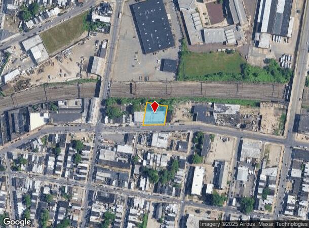
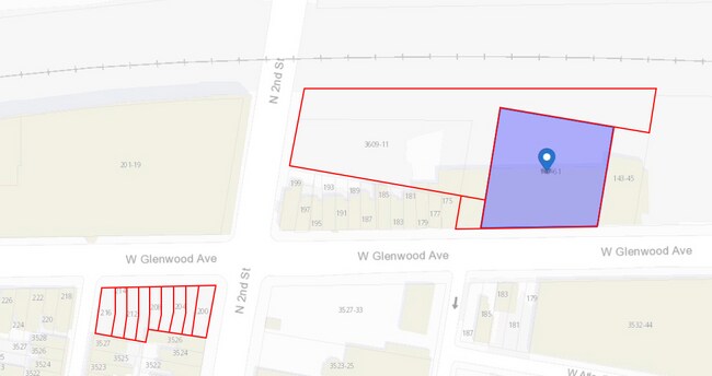
147 W Glenwood Ave, Philadelphia, PA 19140

This Property Is For Sale
NEARBY LISTINGS FOR SALE OR LEASE
Property Detail
147 W Glenwood Ave
884341250
Louis Chartock
Warehouse
NEC PALETHORPE ST
X
Philadelphia
42091C0395G
Pennsylvania
2024
0.35 AC
2026
Lower North Philly
019800
Philadelphia
8,291 SF
Philadelphia-Camden-Wilmington, PA-NJ-DE-MD
DEMOGRAPHICS near 147 W Glenwood Ave
1 Mile
3 Mile
5 Mile
2024 Total Population
52,451
438,470
988,260
2029 Population
50,782
428,312
963,475
Pop Growth 2024-2029
(3.18%)
(2.32%)
(2.51%)
Average Age
36
36
37
2024 Total Households
17,902
165,940
403,228
HH Growth 2024-2029
(3.46%)
(2.40%)
(2.66%)
Median Household Inc
$23,581
$36,961
$51,889
Avg Household Size
2.80
2.50
2.30
2024 Avg HH Vehicles
1.00
1.00
1.00
Median Home Value
$68,573
$152,015
$199,571
Median Year Built
1946
1947
1949
Nearby Places
Map Layers
Map Styles
 Street
 Aerial
- Restaurants
- Banks
- Shops
- Fitness
- Groceries
PUBLIC TRANSPORTATION
COMMUTER RAIL
North Philadelphia (Broad Street Line - Southeastern Pennsylvania Transportation Authority Rapid Transit (SEPTA Subway & Trolley))
DRIVE
WALK
Distance
North Philadelphia (Broad Street Line - Southeastern Pennsylvania Transportation Authority Rapid Transit (SEPTA Subway & Trolley))
5 min
1.5 mi
North Philadelphia (R7 - Southeastern Pennsylvania Transportation Authority Regional Rail (SEPTA Regional Rail), R8 - Southeastern Pennsylvania Transportation Authority Regional Rail (SEPTA Regional Rail))
DRIVE
WALK
Distance
North Philadelphia (R7 - Southeastern Pennsylvania Transportation Authority Regional Rail (SEPTA Regional Rail), R8 - Southeastern Pennsylvania Transportation Authority Regional Rail (SEPTA Regional Rail))
5 min
1.7 mi
AIRPORT
Philadelphia International
DRIVE
WALK
Distance
Philadelphia International
28 min
16.0 mi
Trenton Mercer
DRIVE
WALK
Distance
Trenton Mercer
47 min
30.6 mi
Freight Ports
Port of Philadelphia
DRIVE
WALK
Distance
Port of Philadelphia
9 min
3.5 mi
Nearby Properties
Address
Land Use
TOTAL SIZE
Lot Size
Zoning
Address
Land Use
TOTAL SIZE
Lot Size
Zoning
880,950 SF
27.71 AC
SPENT
Address
Land Use
TOTAL SIZE
Lot Size
Zoning
1.88 AC
SPINS
Address
Land Use
TOTAL SIZE
Lot Size
Zoning
804,000 SF
4.29 AC
CMX3
Address
Land Use
TOTAL SIZE
Lot Size
Zoning
461,286 SF
2.64 AC
CMX4
Address
Land Use
TOTAL SIZE
Lot Size
Zoning
500,875 SF
4.31 AC
RM1
Address
Land Use
TOTAL SIZE
Lot Size
Zoning
455,889 SF
33 AC
I2
Address
Land Use
TOTAL SIZE
Lot Size
Zoning
380,040 SF
1.22 AC
ICMX
Address
Land Use
TOTAL SIZE
Lot Size
Zoning
285,615 SF
1.46 AC
SPINS
Address
Land Use
TOTAL SIZE
Lot Size
Zoning
254,947 SF
1.73 AC
CMX4
Address
Land Use
TOTAL SIZE
Lot Size
Zoning
96,574 SF
2.42 AC
RM2
Address
Land Use
TOTAL SIZE
Lot Size
Zoning
485,616 SF
8.96 AC
CMX3
Address
Land Use
TOTAL SIZE
Lot Size
Zoning
242,655 SF
3.29 AC
CMX3
Address
Land Use
TOTAL SIZE
Lot Size
Zoning
425,535 SF
4.60 AC
RM3
Address
Land Use
TOTAL SIZE
Lot Size
Zoning
3,590 SF
50 AC
SPPOA
Address
Land Use
TOTAL SIZE
Lot Size
Zoning
324,477 SF
1.99 AC
CMX4
Address
Land Use
TOTAL SIZE
Lot Size
Zoning
293,510 SF
7.03 AC
SPINS
Address
Land Use
TOTAL SIZE
Lot Size
Zoning
17,886 SF
80 AC
SPPOA
Address
Land Use
TOTAL SIZE
Lot Size
Zoning
390,773 SF
2.86 AC
CMX3
Address
Land Use
TOTAL SIZE
Lot Size
Zoning
164,412 SF
4.44 AC
SPINS
Address
Land Use
TOTAL SIZE
Lot Size
Zoning
234,684 SF
0.45 AC
CMX4
Address
Land Use
TOTAL SIZE
Lot Size
Zoning
829,504 SF
4.77 AC
SPINS
Address
Land Use
TOTAL SIZE
Lot Size
Zoning
128,164 SF
6.82 AC
SPINS
Address
Land Use
TOTAL SIZE
Lot Size
Zoning
218,960 SF
1.55 AC
RM2
Address
Land Use
TOTAL SIZE
Lot Size
Zoning
425,128 SF
23 AC
RSA5
Address
Land Use
TOTAL SIZE
Lot Size
Zoning
504,972 SF
16.30 AC
RM2
Address
Land Use
TOTAL SIZE
Lot Size
Zoning
425,000 SF
2.08 AC
SPINS
Address
Land Use
TOTAL SIZE
Lot Size
Zoning
163,400 SF
1.20 AC
CMX3
Address
Land Use
TOTAL SIZE
Lot Size
Zoning
500,000 SF
2.30 AC
CMX3
Address
Land Use
TOTAL SIZE
Lot Size
Zoning
265,000 SF
1.83 AC
CMX3
Address
Land Use
TOTAL SIZE
Lot Size
Zoning
218,030 SF
23.75 AC
CA2
The World's #1 Commercial Real Estate Marketplace
Connect with us
© 2025 CoStar Group
The information above has been obtained from sources believed reliable. While we do not doubt its accuracy we have not verified it and make no guarantee, warranty or representation about it. It is your responsibility to independently confirm its accuracy and completeness. Any projections, opinions, assumptions, or estimates used are for example only and do not represent the current or future performance of the property. The value of this transaction to you depends on tax and other factors which should be evaluated by your tax, financial, and legal advisors. You and your advisors should conduct a careful, independent investigation of the property to determine to your satisfaction the suitability of the property for your needs.