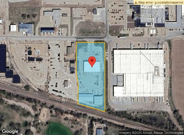
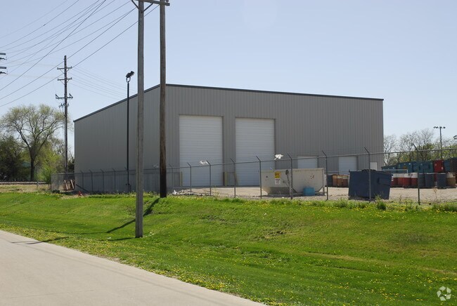
Property Record
147 E Roberts St, Grand Island, NE 68803


NEARBY LISTINGS FOR SALE OR LEASE
-
-
View all Grand Island listings for sale on LoopNet.com
Property Detail
147 E Roberts St
Grand Island, NE
Roberts Sub
400084112
ROBERTS SUB LT 7; MAP NUMBER: 3315-00-0-14440-000-0007
Officebuilding
Hall
X
Nebraska
31081C0125D
7
2024
4.10 AC
2025
I-80 Corridor
000200
Other Market Areas
1,800 SF
DEMOGRAPHICS near 147 E Roberts St
1 Mile
3 Mile
5 Mile
2024 Total Population
6,153
41,305
55,149
2029 Population
6,066
40,766
54,376
Pop Growth 2024-2029
(1.41%)
(1.30%)
(1.40%)
Average Age
35
37
38
2024 Total Households
2,209
15,489
20,854
HH Growth 2024-2029
(1.36%)
(1.32%)
(1.41%)
Median Household Inc
$57,163
$57,845
$61,435
Avg Household Size
2.70
2.60
2.50
2024 Avg HH Vehicles
2.00
2.00
2.00
Median Home Value
$137,226
$156,805
$174,306
Median Year Built
1964
1969
1973
Nearby Places
Map Layers
Map Styles
 Street
 Aerial
- Restaurants
- Banks
- Shops
- Fitness
- Groceries
PUBLIC TRANSPORTATION
AIRPORT
Central Nebraska Regional
DRIVE
WALK
Distance
Central Nebraska Regional
8 min
3.7 mi
Nearby Properties
Address
Land Use
TOTAL SIZE
Lot Size
Zoning
Address
Land Use
TOTAL SIZE
Lot Size
Zoning
200 SF
50.67 AC
04-INDUSTR
Address
Land Use
TOTAL SIZE
Lot Size
Zoning
6 SF
13.46 AC
03-COMMERC
Address
Land Use
TOTAL SIZE
Lot Size
Zoning
3,776 SF
6.98 AC
03-COMMERC
Address
Land Use
TOTAL SIZE
Lot Size
Zoning
205,484 SF
22.31 AC
03-COMMERC
Address
Land Use
TOTAL SIZE
Lot Size
Zoning
6,800 SF
13.38 AC
04-INDUSTR
Address
Land Use
TOTAL SIZE
Lot Size
Zoning
68,240 SF
7.59 AC
03-COMMERC
Address
Land Use
TOTAL SIZE
Lot Size
Zoning
42,900 SF
16.96 AC
03-COMMERC
Address
Land Use
TOTAL SIZE
Lot Size
Zoning
131,800 SF
20.57 AC
03-COMMERC
Address
Land Use
TOTAL SIZE
Lot Size
Zoning
108,990 SF
1 AC
04-INDUSTR
Address
Land Use
TOTAL SIZE
Lot Size
Zoning
2,343 SF
12.26 AC
03-COMMERC
Address
Land Use
TOTAL SIZE
Lot Size
Zoning
13,960 SF
6.06 AC
03-COMMERC
Address
Land Use
TOTAL SIZE
Lot Size
Zoning
73,016 SF
2.31 AC
03-COMMERC
Address
Land Use
TOTAL SIZE
Lot Size
Zoning
0.02 AC
03-COMMERC
Address
Land Use
TOTAL SIZE
Lot Size
Zoning
83,763 SF
8.39 AC
03-COMMERC
Address
Land Use
TOTAL SIZE
Lot Size
Zoning
46,170 SF
2.13 AC
03-COMMERC
Address
Land Use
TOTAL SIZE
Lot Size
Zoning
60,756 SF
1.31 AC
03-COMMERC
Address
Land Use
TOTAL SIZE
Lot Size
Zoning
78,228 SF
3.91 AC
03-COMMERC
Address
Land Use
TOTAL SIZE
Lot Size
Zoning
68,378 SF
1.74 AC
03-COMMERC
Address
Land Use
TOTAL SIZE
Lot Size
Zoning
76,749 SF
8.39 AC
03-COMMERC
Address
Land Use
TOTAL SIZE
Lot Size
Zoning
94,482 SF
10.88 AC
05-AGRICUL
Address
Land Use
TOTAL SIZE
Lot Size
Zoning
73,512 SF
8.49 AC
03-COMMERC
Address
Land Use
TOTAL SIZE
Lot Size
Zoning
14,702 SF
5.24 AC
03-COMMERC
Address
Land Use
TOTAL SIZE
Lot Size
Zoning
39,577 SF
2.51 AC
03-COMMERC
Address
Land Use
TOTAL SIZE
Lot Size
Zoning
98,419 SF
5.46 AC
04-INDUSTR
Address
Land Use
TOTAL SIZE
Lot Size
Zoning
35,643 SF
1.53 AC
03-COMMERC
Address
Land Use
TOTAL SIZE
Lot Size
Zoning
60,932 SF
6 AC
03-COMMERC
Address
Land Use
TOTAL SIZE
Lot Size
Zoning
22,491 SF
6.59 AC
03-COMMERC
Address
Land Use
TOTAL SIZE
Lot Size
Zoning
38,880 SF
6.27 AC
04-INDUSTR
Address
Land Use
TOTAL SIZE
Lot Size
Zoning
1,540 SF
9.72 AC
03-COMMERC
Address
Land Use
TOTAL SIZE
Lot Size
Zoning
22,566 SF
3.45 AC
03-COMMERC
The World's #1 Commercial Real Estate Marketplace
Connect with us
© 2025 CoStar Group
The information above has been obtained from sources believed reliable. While we do not doubt its accuracy we have not verified it and make no guarantee, warranty or representation about it. It is your responsibility to independently confirm its accuracy and completeness. Any projections, opinions, assumptions, or estimates used are for example only and do not represent the current or future performance of the property. The value of this transaction to you depends on tax and other factors which should be evaluated by your tax, financial, and legal advisors. You and your advisors should conduct a careful, independent investigation of the property to determine to your satisfaction the suitability of the property for your needs.