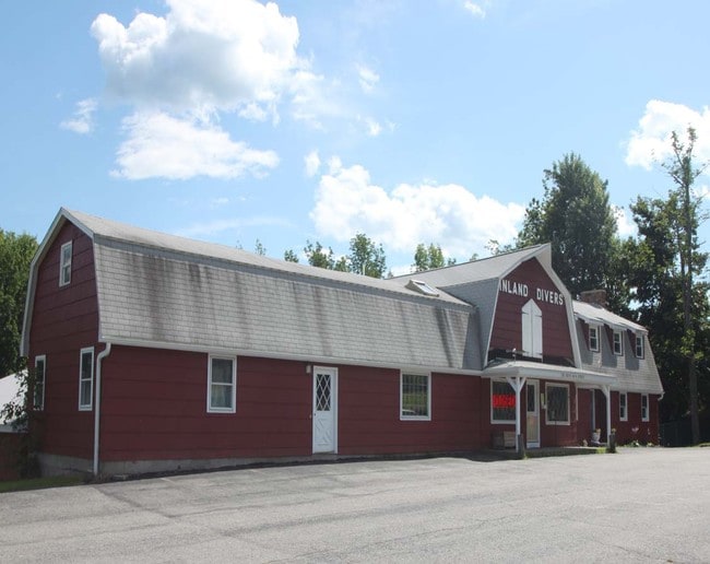
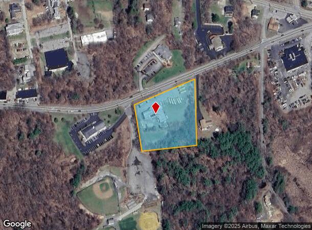
Property Record
100 S Main St, Leicester, MA 01524

NEARBY LISTINGS FOR SALE OR LEASE
Property Detail
100 S Main St
Commercialofficeresidentialmixeduse
Worcester
X
Massachusetts
25027C0782F
2.50 AC
2025
Outlying Worcester
2025
Boston
735100
Worcester, MA-CT
8,158 SF
LEIC-000021-A000004
DEMOGRAPHICS near 100 S Main St
1 Mile
3 Mile
5 Mile
2024 Total Population
2,825
21,888
106,144
2029 Population
2,809
21,708
104,790
Pop Growth 2024-2029
(0.57%)
(0.82%)
(1.28%)
Average Age
42
42
40
2024 Total Households
1,042
8,379
40,464
HH Growth 2024-2029
(0.58%)
(0.82%)
(1.29%)
Median Household Inc
$79,194
$79,606
$68,848
Avg Household Size
2.50
2.50
2.50
2024 Avg HH Vehicles
2.00
2.00
2.00
Median Home Value
$338,511
$316,305
$334,229
Median Year Built
1958
1966
1950
Nearby Places
Map Layers
Map Styles
 Street
 Aerial
- Restaurants
- Banks
- Shops
- Fitness
- Groceries
PUBLIC TRANSPORTATION
COMMUTER RAIL
Worcester Union Station (Lake Shore Limited - Amtrak)
DRIVE
WALK
Distance
Worcester Union Station (Lake Shore Limited - Amtrak)
10 min
6.3 mi
Worcester (Framingham/Worcester Line - Massachusetts Bay Transportation Authority Commuter Rail (Purple Line))
DRIVE
WALK
Distance
Worcester (Framingham/Worcester Line - Massachusetts Bay Transportation Authority Commuter Rail (Purple Line))
10 min
6.5 mi
AIRPORT
Worcester Regional
DRIVE
WALK
Distance
Worcester Regional
12 min
6.0 mi
Freight Ports
Port of Boston
DRIVE
WALK
Distance
Port of Boston
70 min
51.6 mi
SALE & LEASE HISTORY
LISTING DATE
SALE/LEASE

Sep 23, 2016
For Sale
Nearby Properties
Address
Land Use
TOTAL SIZE
Lot Size
Zoning
Address
Land Use
TOTAL SIZE
Lot Size
Zoning
49.08 AC
SA
Address
Land Use
TOTAL SIZE
Lot Size
Zoning
244,486 SF
42.64 AC
RL-7
Address
Land Use
TOTAL SIZE
Lot Size
Zoning
177.12 AC
RL-7
Address
Land Use
TOTAL SIZE
Lot Size
Zoning
41.84 AC
Address
Land Use
TOTAL SIZE
Lot Size
Zoning
643,250 SF
35.17 AC
RL-7
Address
Land Use
TOTAL SIZE
Lot Size
Zoning
14.66 AC
BG-2
Address
Land Use
TOTAL SIZE
Lot Size
Zoning
11 AC
RS-7
Address
Land Use
TOTAL SIZE
Lot Size
Zoning
267,600 SF
45.87 AC
R2
Address
Land Use
TOTAL SIZE
Lot Size
Zoning
1,408 SF
42.06 AC
HB1
Address
Land Use
TOTAL SIZE
Lot Size
Zoning
176,000 SF
19.52 AC
RL-7
Address
Land Use
TOTAL SIZE
Lot Size
Zoning
24,000 SF
10.60 AC
SA
Address
Land Use
TOTAL SIZE
Lot Size
Zoning
206,992 SF
55.33 AC
HB1
Address
Land Use
TOTAL SIZE
Lot Size
Zoning
53,192 SF
26.65 AC
RL-7
Address
Land Use
TOTAL SIZE
Lot Size
Zoning
93,548 SF
1.43 AC
BL-1
Address
Land Use
TOTAL SIZE
Lot Size
Zoning
40 AC
B
Address
Land Use
TOTAL SIZE
Lot Size
Zoning
124,100 SF
5.03 AC
RG-5
Address
Land Use
TOTAL SIZE
Lot Size
Zoning
201,195 SF
16.20 AC
BL-1
Address
Land Use
TOTAL SIZE
Lot Size
Zoning
76,586 SF
20.44 AC
R2
Address
Land Use
TOTAL SIZE
Lot Size
Zoning
190,020 SF
7.35 AC
RL-7
Address
Land Use
TOTAL SIZE
Lot Size
Zoning
7.26 AC
RL-7
Address
Land Use
TOTAL SIZE
Lot Size
Zoning
87,144 SF
12.03 AC
IP-.33
Address
Land Use
TOTAL SIZE
Lot Size
Zoning
17 AC
HB1
Address
Land Use
TOTAL SIZE
Lot Size
Zoning
175,701 SF
25.85 AC
HB2
Address
Land Use
TOTAL SIZE
Lot Size
Zoning
12.20 AC
IP-.33
Address
Land Use
TOTAL SIZE
Lot Size
Zoning
3,552 SF
13 AC
NB
Address
Land Use
TOTAL SIZE
Lot Size
Zoning
9.40 AC
HB1
Address
Land Use
TOTAL SIZE
Lot Size
Zoning
34.30 AC
RL-7
Address
Land Use
TOTAL SIZE
Lot Size
Zoning
19 AC
MG-1
Address
Land Use
TOTAL SIZE
Lot Size
Zoning
5.26 AC
RL-7
Address
Land Use
TOTAL SIZE
Lot Size
Zoning
51,755 SF
5.93 AC
R1
The World's #1 Commercial Real Estate Marketplace
Connect with us
© 2025 CoStar Group
The information above has been obtained from sources believed reliable. While we do not doubt its accuracy we have not verified it and make no guarantee, warranty or representation about it. It is your responsibility to independently confirm its accuracy and completeness. Any projections, opinions, assumptions, or estimates used are for example only and do not represent the current or future performance of the property. The value of this transaction to you depends on tax and other factors which should be evaluated by your tax, financial, and legal advisors. You and your advisors should conduct a careful, independent investigation of the property to determine to your satisfaction the suitability of the property for your needs.