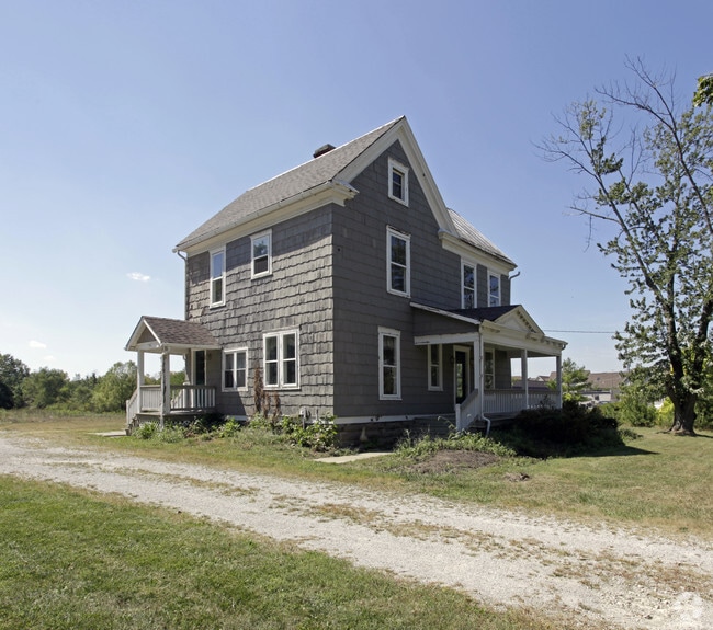
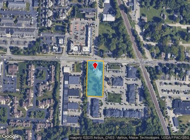
Property Record
173 W Olentangy St, Powell, OH 43065

NEARBY LISTINGS FOR SALE OR LEASE
Property Detail
173 W Olentangy St
319-432-02-003-000
LANDS 19 3 4 30 TIF AREA
Storebuilding
Delaware
X
Ohio
39041C0237L
1.11 AC
2024
Outlying Delaware County
2024
Columbus
011421
Columbus, OH
2,160 SF
DEMOGRAPHICS near 173 W Olentangy St
1 Mile
3 Mile
5 Mile
2024 Total Population
9,185
58,130
166,055
2029 Population
10,460
62,888
176,958
Pop Growth 2024-2029
+ 13.88%
+ 8.19%
+ 6.57%
Average Age
41
39
39
2024 Total Households
3,462
20,895
62,657
HH Growth 2024-2029
+ 14.10%
+ 8.08%
+ 6.26%
Median Household Inc
$145,161
$137,199
$120,368
Avg Household Size
2.60
2.80
2.60
2024 Avg HH Vehicles
2.00
2.00
2.00
Median Home Value
$411,221
$416,851
$394,378
Median Year Built
1997
1992
1993
Nearby Places
Map Layers
Map Styles
 Street
 Aerial
- Restaurants
- Banks
- Shops
- Fitness
- Groceries
PUBLIC TRANSPORTATION
AIRPORT
John Glenn Columbus International
DRIVE
WALK
Distance
John Glenn Columbus International
31 min
21.6 mi
Rickenbacker International
DRIVE
WALK
Distance
Rickenbacker International
47 min
31.7 mi
SALE & LEASE HISTORY
LISTING DATE
SALE/LEASE

Oct 25, 2023
For Lease
Jul 27, 2023
For Sale
Nearby Properties
Address
Land Use
TOTAL SIZE
Lot Size
Zoning
Address
Land Use
TOTAL SIZE
Lot Size
Zoning
90.16 AC
Address
Land Use
TOTAL SIZE
Lot Size
Zoning
56,770 SF
22.62 AC
Address
Land Use
TOTAL SIZE
Lot Size
Zoning
232,579 SF
54.30 AC
Address
Land Use
TOTAL SIZE
Lot Size
Zoning
48,009 SF
17.24 AC
Address
Land Use
TOTAL SIZE
Lot Size
Zoning
247,368 SF
7.88 AC
Address
Land Use
TOTAL SIZE
Lot Size
Zoning
67,908 SF
32.65 AC
Address
Land Use
TOTAL SIZE
Lot Size
Zoning
159,901 SF
19.97 AC
Address
Land Use
TOTAL SIZE
Lot Size
Zoning
128,522 SF
13.43 AC
Address
Land Use
TOTAL SIZE
Lot Size
Zoning
69.13 AC
Address
Land Use
TOTAL SIZE
Lot Size
Zoning
138,296 SF
21.07 AC
Address
Land Use
TOTAL SIZE
Lot Size
Zoning
151,623 SF
27.47 AC
Address
Land Use
TOTAL SIZE
Lot Size
Zoning
138,004 SF
19.99 AC
Address
Land Use
TOTAL SIZE
Lot Size
Zoning
21,184 SF
16.59 AC
Address
Land Use
TOTAL SIZE
Lot Size
Zoning
171,530 SF
13.28 AC
Address
Land Use
TOTAL SIZE
Lot Size
Zoning
136,123 SF
5.07 AC
Address
Land Use
TOTAL SIZE
Lot Size
Zoning
96,797 SF
16.73 AC
Address
Land Use
TOTAL SIZE
Lot Size
Zoning
16,735 SF
10.40 AC
Address
Land Use
TOTAL SIZE
Lot Size
Zoning
6,676 SF
478.74 AC
Address
Land Use
TOTAL SIZE
Lot Size
Zoning
103,836 SF
9.98 AC
Address
Land Use
TOTAL SIZE
Lot Size
Zoning
83,734 SF
20.24 AC
Address
Land Use
TOTAL SIZE
Lot Size
Zoning
112,516 SF
25.26 AC
Address
Land Use
TOTAL SIZE
Lot Size
Zoning
77,626 SF
17.62 AC
Address
Land Use
TOTAL SIZE
Lot Size
Zoning
57,750 SF
51.32 AC
Address
Land Use
TOTAL SIZE
Lot Size
Zoning
47,336 SF
5.76 AC
Address
Land Use
TOTAL SIZE
Lot Size
Zoning
70,263 SF
16.76 AC
Address
Land Use
TOTAL SIZE
Lot Size
Zoning
9,493 SF
248.77 AC
Address
Land Use
TOTAL SIZE
Lot Size
Zoning
12,208 SF
10.88 AC
Address
Land Use
TOTAL SIZE
Lot Size
Zoning
47,426 SF
18.11 AC
Address
Land Use
TOTAL SIZE
Lot Size
Zoning
86,046 SF
20.36 AC
Address
Land Use
TOTAL SIZE
Lot Size
Zoning
47,548 SF
9.28 AC
The World's #1 Commercial Real Estate Marketplace
Connect with us
© 2025 CoStar Group
The information above has been obtained from sources believed reliable. While we do not doubt its accuracy we have not verified it and make no guarantee, warranty or representation about it. It is your responsibility to independently confirm its accuracy and completeness. Any projections, opinions, assumptions, or estimates used are for example only and do not represent the current or future performance of the property. The value of this transaction to you depends on tax and other factors which should be evaluated by your tax, financial, and legal advisors. You and your advisors should conduct a careful, independent investigation of the property to determine to your satisfaction the suitability of the property for your needs.