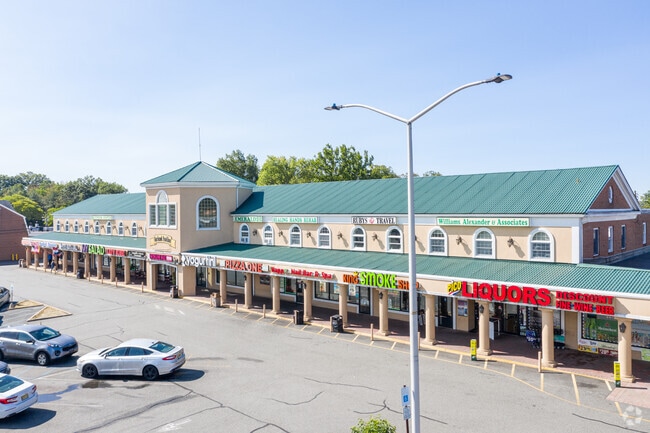
Property Record
1467 Route 23, Wayne, NJ 07470
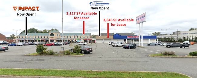
Current Lease Availabilities
NEARBY LISTINGS FOR SALE OR LEASE
Property Detail
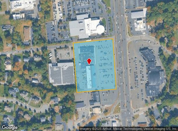
1467 Route 23
New York-Jersey City-White Plains, NY-NJ
Passaic
14-01410-0000-00002
New Jersey
Sfr
5.20 AC
A
Passaic Rt 46/23
34027C0192F
Northern New Jersey
DEMOGRAPHICS near 1467 Route 23
1 Mile
3 Mile
5 Mile
2024 Total Population
5,976
65,979
195,148
2029 Population
5,935
65,640
192,114
Pop Growth 2024-2029
(0.69%)
(0.51%)
(1.55%)
Average Age
41
43
42
2024 Total Households
1,995
23,568
67,943
HH Growth 2024-2029
(1.00%)
(0.70%)
(1.61%)
Median Household Inc
$150,515
$126,379
$107,152
Avg Household Size
2.90
2.70
2.80
2024 Avg HH Vehicles
2.00
2.00
2.00
Median Home Value
$559,156
$517,262
$479,539
Median Year Built
1956
1964
1964
Nearby Places
Map Layers
Map Styles
 Street
 Aerial
- Restaurants
- Banks
- Shops
- Fitness
- Groceries
PUBLIC TRANSPORTATION
COMMUTER RAIL
Mountain View (Montclair-Boonton Line - NJ Transit Commuter Rail (NJ Transit))
DRIVE
WALK
Distance
Mountain View (Montclair-Boonton Line - NJ Transit Commuter Rail (NJ Transit))
4 min
2.2 mi
Wayne/Route 23 Transit Center (Montclair-Boonton Line - NJ Transit Commuter Rail (NJ Transit))
DRIVE
WALK
Distance
Wayne/Route 23 Transit Center (Montclair-Boonton Line - NJ Transit Commuter Rail (NJ Transit))
5 min
2.8 mi
AIRPORT
Newark Liberty International
DRIVE
WALK
Distance
Newark Liberty International
30 min
24.4 mi
LaGuardia
DRIVE
WALK
Distance
LaGuardia
46 min
32.3 mi
Westchester County
DRIVE
WALK
Distance
Westchester County
67 min
48.1 mi
Freight Ports
Maher Terminal
DRIVE
WALK
Distance
Maher Terminal
36 min
24.3 mi
Nearby Properties
Address
Land Use
TOTAL SIZE
Lot Size
Zoning
Address
Land Use
TOTAL SIZE
Lot Size
Zoning
56.67 AC
Address
Land Use
TOTAL SIZE
Lot Size
Zoning
21.99 AC
H
Address
Land Use
TOTAL SIZE
Lot Size
Zoning
49,701 SF
29.34 AC
GAR
Address
Land Use
TOTAL SIZE
Lot Size
Zoning
18.76 AC
C-3
Address
Land Use
TOTAL SIZE
Lot Size
Zoning
960 SF
22.84 AC
GWS
Address
Land Use
TOTAL SIZE
Lot Size
Zoning
32.21 AC
R-15
Address
Land Use
TOTAL SIZE
Lot Size
Zoning
207,519 SF
32.39 AC
Address
Land Use
TOTAL SIZE
Lot Size
Zoning
5,880 SF
17.46 AC
I
Address
Land Use
TOTAL SIZE
Lot Size
Zoning
342,518 SF
31.80 AC
IP
Address
Land Use
TOTAL SIZE
Lot Size
Zoning
251,974 SF
27.96 AC
Address
Land Use
TOTAL SIZE
Lot Size
Zoning
192,206 SF
7.73 AC
R-20
Address
Land Use
TOTAL SIZE
Lot Size
Zoning
41.71 AC
C-4
Address
Land Use
TOTAL SIZE
Lot Size
Zoning
97,631 SF
10.01 AC
B-2
Address
Land Use
TOTAL SIZE
Lot Size
Zoning
175,000 SF
12.54 AC
L-1
Address
Land Use
TOTAL SIZE
Lot Size
Zoning
374,755 SF
24.88 AC
Address
Land Use
TOTAL SIZE
Lot Size
Zoning
277,661 SF
50.20 AC
Address
Land Use
TOTAL SIZE
Lot Size
Zoning
148,000 SF
6.44 AC
Address
Land Use
TOTAL SIZE
Lot Size
Zoning
63,460 SF
10.72 AC
Address
Land Use
TOTAL SIZE
Lot Size
Zoning
9,448 SF
13.53 AC
HD
Address
Land Use
TOTAL SIZE
Lot Size
Zoning
259,919 SF
48.14 AC
Address
Land Use
TOTAL SIZE
Lot Size
Zoning
9.08 AC
H-C
Address
Land Use
TOTAL SIZE
Lot Size
Zoning
14.01 AC
Address
Land Use
TOTAL SIZE
Lot Size
Zoning
9.28 AC
R-11
Address
Land Use
TOTAL SIZE
Lot Size
Zoning
10.07 AC
R-15
Address
Land Use
TOTAL SIZE
Lot Size
Zoning
143,500 SF
14.73 AC
I
Address
Land Use
TOTAL SIZE
Lot Size
Zoning
17.30 AC
I3
Address
Land Use
TOTAL SIZE
Lot Size
Zoning
12.24 AC
H-C
Address
Land Use
TOTAL SIZE
Lot Size
Zoning
1,824 SF
243 AC
R-B
Address
Land Use
TOTAL SIZE
Lot Size
Zoning
7,398 SF
13.96 AC
Address
Land Use
TOTAL SIZE
Lot Size
Zoning
82,061 SF
12.39 AC
R-15
The World's #1 Commercial Real Estate Marketplace
Connect with us
© 2026 CoStar Group
The information above has been obtained from sources believed reliable. While we do not doubt its accuracy we have not verified it and make no guarantee, warranty or representation about it. It is your responsibility to independently confirm its accuracy and completeness. Any projections, opinions, assumptions, or estimates used are for example only and do not represent the current or future performance of the property. The value of this transaction to you depends on tax and other factors which should be evaluated by your tax, financial, and legal advisors. You and your advisors should conduct a careful, independent investigation of the property to determine to your satisfaction the suitability of the property for your needs.