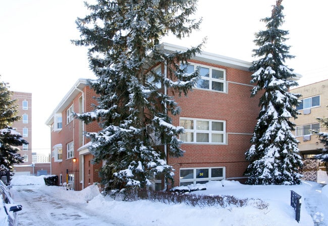
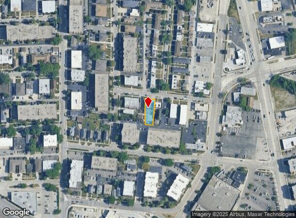
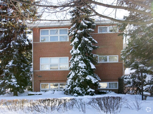
Property Record
1471 Brown St, Des Plaines, IL 60016
NEARBY LISTINGS FOR SALE OR LEASE
Property Detail
1471 Brown St
Chicago-Naperville-Elgin, IL-IN-WI
Desplaines Center
09-17-402-079-0000
(DESPLAINES)(CENTER) SUB IN EH SEC 17-41-12
Apartment
Cook
X
Illinois
17031C0217J
13
2023
0.20 AC
2024
Des Plaines/Arlington Hts Corridor
806201
Chicago
4,597 SF
DEMOGRAPHICS near 1471 Brown St
1 Mile
3 Mile
5 Mile
2024 Total Population
17,013
131,887
321,179
2029 Population
16,588
128,103
311,684
Pop Growth 2024-2029
(2.50%)
(2.87%)
(2.96%)
Average Age
44
43
43
2024 Total Households
8,061
50,124
121,479
HH Growth 2024-2029
(2.74%)
(3.16%)
(3.25%)
Median Household Inc
$71,540
$77,797
$87,630
Avg Household Size
2.10
2.50
2.50
2024 Avg HH Vehicles
1.00
2.00
2.00
Median Home Value
$263,623
$314,267
$356,323
Median Year Built
1983
1967
1967
Nearby Places
Map Layers
Map Styles
 Street
 Aerial
- Restaurants
- Banks
- Shops
- Fitness
- Groceries
PUBLIC TRANSPORTATION
COMMUTER RAIL
Des Plaines Station (Union Pacific Northwest Line - Northeast Illinois Regional Commuter Railroad (Metra))
DRIVE
WALK
Distance
Des Plaines Station (Union Pacific Northwest Line - Northeast Illinois Regional Commuter Railroad (Metra))
1 min
8 min
0.4 mi
Cumberland Station (Union Pacific Northwest Line - Northeast Illinois Regional Commuter Railroad (Metra))
DRIVE
WALK
Distance
Cumberland Station (Union Pacific Northwest Line - Northeast Illinois Regional Commuter Railroad (Metra))
5 min
2.4 mi
AIRPORT
Chicago O'Hare International
DRIVE
WALK
Distance
Chicago O'Hare International
11 min
6.6 mi
Chicago Midway International
DRIVE
WALK
Distance
Chicago Midway International
41 min
22.1 mi
Freight Ports
Port Milwaukee
DRIVE
WALK
Distance
Port Milwaukee
85 min
72.1 mi
Nearby Properties
Address
Land Use
TOTAL SIZE
Lot Size
Zoning
Address
Land Use
TOTAL SIZE
Lot Size
Zoning
6.53 AC
Address
Land Use
TOTAL SIZE
Lot Size
Zoning
206,160 SF
9.44 AC
Address
Land Use
TOTAL SIZE
Lot Size
Zoning
188,728 SF
Address
Land Use
TOTAL SIZE
Lot Size
Zoning
413,338 SF
23.92 AC
Address
Land Use
TOTAL SIZE
Lot Size
Zoning
508,246 SF
32.81 AC
Address
Land Use
TOTAL SIZE
Lot Size
Zoning
234,337 SF
23.59 AC
Address
Land Use
TOTAL SIZE
Lot Size
Zoning
449,568 SF
22.73 AC
Address
Land Use
TOTAL SIZE
Lot Size
Zoning
611,799 SF
17.61 AC
Address
Land Use
TOTAL SIZE
Lot Size
Zoning
378,525 SF
0.11 AC
Address
Land Use
TOTAL SIZE
Lot Size
Zoning
276,112 SF
10.02 AC
Address
Land Use
TOTAL SIZE
Lot Size
Zoning
13.13 AC
Address
Land Use
TOTAL SIZE
Lot Size
Zoning
667,821 SF
20.55 AC
Address
Land Use
TOTAL SIZE
Lot Size
Zoning
6.28 AC
Address
Land Use
TOTAL SIZE
Lot Size
Zoning
489,538 SF
5.94 AC
Address
Land Use
TOTAL SIZE
Lot Size
Zoning
59,013 SF
1.90 AC
Address
Land Use
TOTAL SIZE
Lot Size
Zoning
Address
Land Use
TOTAL SIZE
Lot Size
Zoning
214,200 SF
16.97 AC
Address
Land Use
TOTAL SIZE
Lot Size
Zoning
Address
Land Use
TOTAL SIZE
Lot Size
Zoning
405,484 SF
Address
Land Use
TOTAL SIZE
Lot Size
Zoning
85,014 SF
2.38 AC
Address
Land Use
TOTAL SIZE
Lot Size
Zoning
154,560 SF
3.87 AC
Address
Land Use
TOTAL SIZE
Lot Size
Zoning
23.45 AC
Address
Land Use
TOTAL SIZE
Lot Size
Zoning
161,035 SF
13.57 AC
Address
Land Use
TOTAL SIZE
Lot Size
Zoning
143,002 SF
14.58 AC
Address
Land Use
TOTAL SIZE
Lot Size
Zoning
496,500 SF
48.48 AC
M1-1
Address
Land Use
TOTAL SIZE
Lot Size
Zoning
133,124 SF
9.61 AC
Address
Land Use
TOTAL SIZE
Lot Size
Zoning
31.61 AC
Address
Land Use
TOTAL SIZE
Lot Size
Zoning
1,037,760 SF
17.44 AC
Address
Land Use
TOTAL SIZE
Lot Size
Zoning
271,166 SF
8.50 AC
Address
Land Use
TOTAL SIZE
Lot Size
Zoning
The World's #1 Commercial Real Estate Marketplace
Connect with us
© 2025 CoStar Group
The information above has been obtained from sources believed reliable. While we do not doubt its accuracy we have not verified it and make no guarantee, warranty or representation about it. It is your responsibility to independently confirm its accuracy and completeness. Any projections, opinions, assumptions, or estimates used are for example only and do not represent the current or future performance of the property. The value of this transaction to you depends on tax and other factors which should be evaluated by your tax, financial, and legal advisors. You and your advisors should conduct a careful, independent investigation of the property to determine to your satisfaction the suitability of the property for your needs.