Property Record
1471 Hooksett Rd, Hooksett, NH 03106
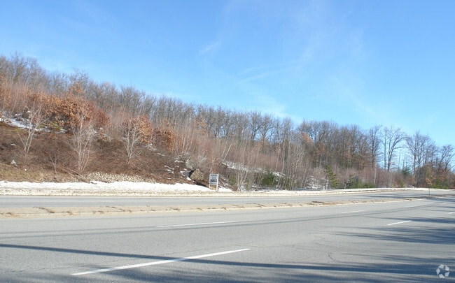

This Property Is For Sale
Property Detail
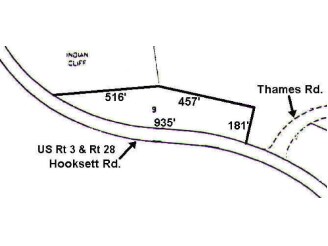
1471 Hooksett Rd
HOOK-000018-000000-000009
MERRIMACK
Commercialacreage
New Hampshire
PZ
3.60 AC
B and X Area of moderate flood hazard, usually the area between the limits of the 100-year and 500-year floods.
Manchester/New Hampshire South Area
2024
Other Market Areas
2024
Concord, NH
003001
NEARBY LISTINGS FOR SALE OR LEASE
DEMOGRAPHICS near 1471 Hooksett Rd
1 mile
3 mile
5 mile
2025 Total Population
2,608
17,510
56,347
2030 Population
2,711
17,962
57,484
Pop Growth 2025-2030
+ 3.95%
+ 2.58%
+ 2.02%
Average Age
44
42
42
2025 Total Households
1,195
7,198
23,557
HH Growth 2025-2030
+ 4.27%
+ 2.76%
+ 2.11%
Median Household Inc
$103,280
$100,769
$101,941
Avg Household Size
2.10
2.30
2.30
2025 Avg HH Vehicles
2.00
2.00
2.00
Median Home Value
$360,162
$425,213
$412,421
Median Year Built
1995
1987
1981
Nearby Places
Map Layers
Map Styles
 Street
 Aerial
Transit
 Traffic
 Biking
Places
Listings with unknown addresses are not visible on the map
- Restaurants
- Banks
- Shops
- Fitness
- Groceries
PUBLIC TRANSPORTATION
AIRPORT
Manchester Boston Regional
Drive
Walk
Distance
Manchester Boston Regional
30 min
14.6 mi
Portsmouth International at Pease
Drive
Walk
Distance
Portsmouth International at Pease
67 min
43.5 mi
Nearby Properties
Address
Land Use
TOTAL SIZE
Lot Size
Zoning
Address
Land Use
TOTAL SIZE
Lot Size
Zoning
58,227 SF
66.52 AC
Address
Land Use
TOTAL SIZE
Lot Size
Zoning
26,232 SF
39.97 AC
Address
Land Use
TOTAL SIZE
Lot Size
Zoning
12.60 AC
PZ
Address
Land Use
TOTAL SIZE
Lot Size
Zoning
36,070 SF
141.66 AC
MUD4
Address
Land Use
TOTAL SIZE
Lot Size
Zoning
51.32 AC
MUD4
Address
Land Use
TOTAL SIZE
Lot Size
Zoning
154,363 SF
17.25 AC
MUD3
Address
Land Use
TOTAL SIZE
Lot Size
Zoning
23,236 SF
26.66 AC
MUD2
Address
Land Use
TOTAL SIZE
Lot Size
Zoning
4,400 SF
76.15 AC
MUD4
Address
Land Use
TOTAL SIZE
Lot Size
Zoning
1,998 SF
72.09 AC
MDR
Address
Land Use
TOTAL SIZE
Lot Size
Zoning
44,301 SF
71.24 AC
Address
Land Use
TOTAL SIZE
Lot Size
Zoning
Address
Land Use
TOTAL SIZE
Lot Size
Zoning
82,670 SF
27.76 AC
PZ
Address
Land Use
TOTAL SIZE
Lot Size
Zoning
69,339 SF
39.63 AC
IND
Address
Land Use
TOTAL SIZE
Lot Size
Zoning
96,192 SF
17.42 AC
IND
Address
Land Use
TOTAL SIZE
Lot Size
Zoning
42,008 SF
4.33 AC
Address
Land Use
TOTAL SIZE
Lot Size
Zoning
95,626 SF
19.51 AC
MUD3
Address
Land Use
TOTAL SIZE
Lot Size
Zoning
85,656 SF
13.56 AC
MUD3
Address
Land Use
TOTAL SIZE
Lot Size
Zoning
153,663 SF
25.16 AC
MUD3
Address
Land Use
TOTAL SIZE
Lot Size
Zoning
73,460 SF
3.56 AC
Address
Land Use
TOTAL SIZE
Lot Size
Zoning
119,910 SF
15.07 AC
MUD3
Address
Land Use
TOTAL SIZE
Lot Size
Zoning
42,008 SF
3.74 AC
Address
Land Use
TOTAL SIZE
Lot Size
Zoning
138,579 SF
16.99 AC
MUD3
Address
Land Use
TOTAL SIZE
Lot Size
Zoning
156,344 SF
19.90 AC
IND
Address
Land Use
TOTAL SIZE
Lot Size
Zoning
93,077 SF
35.96 AC
PZ
Address
Land Use
TOTAL SIZE
Lot Size
Zoning
76,600 SF
18.76 AC
MUD3
Address
Land Use
TOTAL SIZE
Lot Size
Zoning
9,662 SF
76.91 AC
COM
Address
Land Use
TOTAL SIZE
Lot Size
Zoning
57,964 SF
13.85 AC
PZ
Address
Land Use
TOTAL SIZE
Lot Size
Zoning
144,966 SF
13.26 AC
PZ
Address
Land Use
TOTAL SIZE
Lot Size
Zoning
15,645 SF
MUD4
Address
Land Use
TOTAL SIZE
Lot Size
Zoning
61,733 SF
5.12 AC
The World's #1 Commercial Real Estate Marketplace
Connect with us
© 2026 CoStar Group
The information above has been obtained from sources believed reliable. While we do not doubt its accuracy we have not verified it and make no guarantee, warranty or representation about it. It is your responsibility to independently confirm its accuracy and completeness. Any projections, opinions, assumptions, or estimates used are for example only and do not represent the current or future performance of the property. The value of this transaction to you depends on tax and other factors which should be evaluated by your tax, financial, and legal advisors. You and your advisors should conduct a careful, independent investigation of the property to determine to your satisfaction the suitability of the property for your needs.