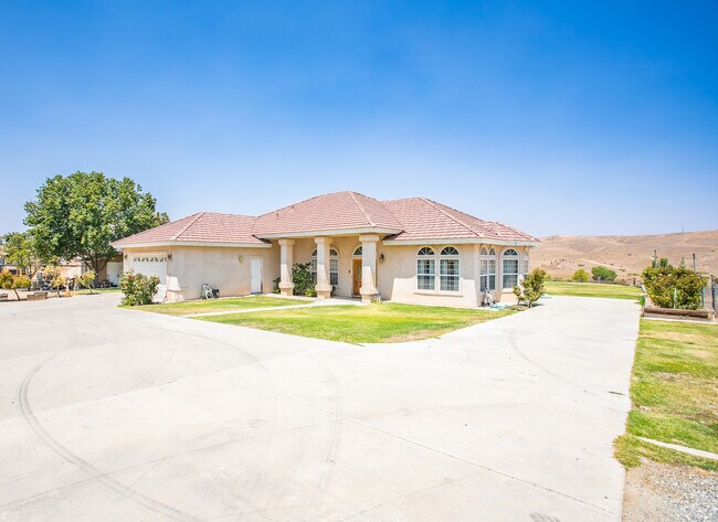
Property Record
14712 Oilfields Rd, Bakersfield, CA 93308


NEARBY LISTINGS FOR SALE OR LEASE
-
-
View all Bakersfield listings for sale on LoopNet.com
Property Detail
14712 Oilfields Rd
074-050-57-00-0
SECTION 35 , TOWNSHIP 27 , RANGE 27 , QUARTER
Sfr
Kern
A
California
06029C1325E
260.54 AC
2024
North Outlying Kern County
2025
Bakersfield
005103
Bakersfield-Delano, CA
2,167 SF
DEMOGRAPHICS near 14712 Oilfields Rd
1 mile
3 mile
5 mile
2024 Total Population
23
141
481
2029 Population
23
138
473
Pop Growth 2024-2029
0.00%
(2.13%)
(1.66%)
Average Age
45
46
40
2024 Total Households
9
59
111
HH Growth 2024-2029
0.00%
(1.69%)
(1.80%)
Median Household Inc
$124,999
$74,999
$81,250
Avg Household Size
2.60
2.40
2.70
2024 Avg HH Vehicles
3.00
3.00
3.00
Median Home Value
$849,999
$600,000
$590,278
Median Year Built
1994
1976
1978
Nearby Places
Map Layers
Map Styles
 Street
 Aerial
Transit
 Traffic
 Biking
Places
Listings with unknown addresses are not visible on the map
- Restaurants
- Banks
- Shops
- Fitness
- Groceries
PUBLIC TRANSPORTATION
AIRPORT
Meadows Field
Drive
Walk
Distance
Meadows Field
27 min
11.1 mi
Freight Ports
The Port of Hueneme
Drive
Walk
Distance
The Port of Hueneme
176 min
136.2 mi
SALE & LEASE HISTORY
LISTING DATE
SALE/LEASE

Nov 17, 2021
For Sale
Nearby Properties
Address
Land Use
TOTAL SIZE
Lot Size
Zoning
Address
Land Use
TOTAL SIZE
Lot Size
Zoning
40 AC
A1
Address
Land Use
TOTAL SIZE
Lot Size
Zoning
6,528 SF
20.51 AC
A
Address
Land Use
TOTAL SIZE
Lot Size
Zoning
160 AC
A
Address
Land Use
TOTAL SIZE
Lot Size
Zoning
2,963 SF
5.18 AC
E
Address
Land Use
TOTAL SIZE
Lot Size
Zoning
20.47 AC
A
Address
Land Use
TOTAL SIZE
Lot Size
Zoning
4,436 SF
20 AC
A
Address
Land Use
TOTAL SIZE
Lot Size
Zoning
2,253 SF
6.58 AC
E(5)
Address
Land Use
TOTAL SIZE
Lot Size
Zoning
3,050 SF
20.49 AC
A1
Address
Land Use
TOTAL SIZE
Lot Size
Zoning
3,035 SF
20 AC
A
Address
Land Use
TOTAL SIZE
Lot Size
Zoning
160 AC
A
Address
Land Use
TOTAL SIZE
Lot Size
Zoning
2,285 SF
20.14 AC
A
Address
Land Use
TOTAL SIZE
Lot Size
Zoning
2,547 SF
20.53 AC
A
Address
Land Use
TOTAL SIZE
Lot Size
Zoning
4,834 SF
19.99 AC
A
Address
Land Use
TOTAL SIZE
Lot Size
Zoning
3,125 SF
5 AC
NR
Address
Land Use
TOTAL SIZE
Lot Size
Zoning
3,325 SF
5 AC
E
Address
Land Use
TOTAL SIZE
Lot Size
Zoning
3,845 SF
5 AC
E
Address
Land Use
TOTAL SIZE
Lot Size
Zoning
3,127 SF
20.49 AC
A1
Address
Land Use
TOTAL SIZE
Lot Size
Zoning
1,014 SF
20 AC
A
Address
Land Use
TOTAL SIZE
Lot Size
Zoning
2,419 SF
5.07 AC
E
Address
Land Use
TOTAL SIZE
Lot Size
Zoning
972 SF
5.01 AC
A1
Address
Land Use
TOTAL SIZE
Lot Size
Zoning
20.47 AC
A1
Address
Land Use
TOTAL SIZE
Lot Size
Zoning
2,120 SF
5.34 AC
E
Address
Land Use
TOTAL SIZE
Lot Size
Zoning
2,086 SF
5 AC
NR
Address
Land Use
TOTAL SIZE
Lot Size
Zoning
2,112 SF
5.09 AC
E
Address
Land Use
TOTAL SIZE
Lot Size
Zoning
1,344 SF
5.05 AC
A1
Address
Land Use
TOTAL SIZE
Lot Size
Zoning
1,963 SF
5 AC
E
Address
Land Use
TOTAL SIZE
Lot Size
Zoning
3,772 SF
5.11 AC
NR
Address
Land Use
TOTAL SIZE
Lot Size
Zoning
2,125 SF
5.34 AC
E
Address
Land Use
TOTAL SIZE
Lot Size
Zoning
1,829 SF
5.05 AC
A1
The World's #1 Commercial Real Estate Marketplace
Connect with us
© 2026 CoStar Group
The information above has been obtained from sources believed reliable. While we do not doubt its accuracy we have not verified it and make no guarantee, warranty or representation about it. It is your responsibility to independently confirm its accuracy and completeness. Any projections, opinions, assumptions, or estimates used are for example only and do not represent the current or future performance of the property. The value of this transaction to you depends on tax and other factors which should be evaluated by your tax, financial, and legal advisors. You and your advisors should conduct a careful, independent investigation of the property to determine to your satisfaction the suitability of the property for your needs.