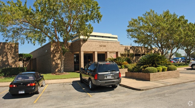
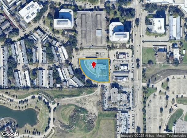
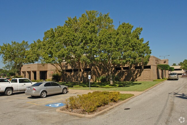
Property Record
14730 Barryknoll Ln, Houston, TX 77079

Current Lease Availabilities
NEARBY LISTINGS FOR SALE OR LEASE
Property Detail
14730 Barryknoll Ln
1023090000003
St Marys Street Extn London Lane Apt
Medicalbuilding
TR C2 BLK 3 & RES B2-1 ST MARYS STREET EXTN LONDON LANE APT
X
Harris
48201C0640M
Texas
2024
1.68 AC
2025
Katy Freeway West
450402
Houston
20,259 SF
Houston-Pasadena-The Woodlands, TX
DEMOGRAPHICS near 14730 Barryknoll Ln
1 mile
3 mile
5 mile
2024 Total Population
17,584
106,237
272,595
2029 Population
17,959
108,565
278,905
Pop Growth 2024-2029
+ 2.13%
+ 2.19%
+ 2.31%
Average Age
36
38
38
2024 Total Households
7,353
45,316
112,679
HH Growth 2024-2029
+ 1.88%
+ 2.11%
+ 2.30%
Median Household Inc
$64,100
$71,205
$65,716
Avg Household Size
2.30
2.30
2.40
2024 Avg HH Vehicles
2.00
2.00
2.00
Median Home Value
$288,666
$401,860
$357,161
Median Year Built
1979
1986
1985
Nearby Places
Map Layers
Map Styles
 Street
 Aerial
Transit
 Traffic
 Biking
Places
Listings with unknown addresses are not visible on the map
- Restaurants
- Banks
- Shops
- Fitness
- Groceries
PUBLIC TRANSPORTATION
AIRPORT
William P Hobby
Drive
Walk
Distance
William P Hobby
44 min
28.6 mi
George Bush Intcntl/Houston
Drive
Walk
Distance
George Bush Intcntl/Houston
38 min
29.9 mi
Freight Ports
Port of Houston
Drive
Walk
Distance
Port of Houston
37 min
25.4 mi
Nearby Properties
Address
Land Use
TOTAL SIZE
Lot Size
Zoning
Address
Land Use
TOTAL SIZE
Lot Size
Zoning
2,976,779 SF
41.36 AC
Address
Land Use
TOTAL SIZE
Lot Size
Zoning
1,385,616 SF
6.48 AC
Address
Land Use
TOTAL SIZE
Lot Size
Zoning
1,131,022 SF
6.26 AC
Address
Land Use
TOTAL SIZE
Lot Size
Zoning
1,208,144 SF
6.15 AC
Address
Land Use
TOTAL SIZE
Lot Size
Zoning
955,731 SF
3.40 AC
Address
Land Use
TOTAL SIZE
Lot Size
Zoning
759,908 SF
4.54 AC
Address
Land Use
TOTAL SIZE
Lot Size
Zoning
953,143 SF
63.82 AC
Address
Land Use
TOTAL SIZE
Lot Size
Zoning
1,543,856 SF
10.03 AC
Address
Land Use
TOTAL SIZE
Lot Size
Zoning
764,429 SF
6.78 AC
Address
Land Use
TOTAL SIZE
Lot Size
Zoning
1,045,896 SF
11.14 AC
Address
Land Use
TOTAL SIZE
Lot Size
Zoning
683,397 SF
2.97 AC
Address
Land Use
TOTAL SIZE
Lot Size
Zoning
569,641 SF
5.69 AC
Address
Land Use
TOTAL SIZE
Lot Size
Zoning
306,572 SF
25.46 AC
Address
Land Use
TOTAL SIZE
Lot Size
Zoning
690,519 SF
26.57 AC
Address
Land Use
TOTAL SIZE
Lot Size
Zoning
617,832 SF
9.24 AC
Address
Land Use
TOTAL SIZE
Lot Size
Zoning
320,534 SF
2.32 AC
Address
Land Use
TOTAL SIZE
Lot Size
Zoning
422,801 SF
12.71 AC
Address
Land Use
TOTAL SIZE
Lot Size
Zoning
520,277 SF
10.04 AC
Address
Land Use
TOTAL SIZE
Lot Size
Zoning
207,841 SF
1.19 AC
Address
Land Use
TOTAL SIZE
Lot Size
Zoning
601,167 SF
14.93 AC
Address
Land Use
TOTAL SIZE
Lot Size
Zoning
845,902 SF
16.27 AC
Address
Land Use
TOTAL SIZE
Lot Size
Zoning
341,801 SF
9.72 AC
Address
Land Use
TOTAL SIZE
Lot Size
Zoning
533,048 SF
5.80 AC
Address
Land Use
TOTAL SIZE
Lot Size
Zoning
672,183 SF
8.80 AC
Address
Land Use
TOTAL SIZE
Lot Size
Zoning
803,103 SF
5.78 AC
Address
Land Use
TOTAL SIZE
Lot Size
Zoning
638,248 SF
23.38 AC
Address
Land Use
TOTAL SIZE
Lot Size
Zoning
927,684 SF
4.38 AC
Address
Land Use
TOTAL SIZE
Lot Size
Zoning
828,328 SF
3.90 AC
Address
Land Use
TOTAL SIZE
Lot Size
Zoning
856,208 SF
4.11 AC
Address
Land Use
TOTAL SIZE
Lot Size
Zoning
910,592 SF
6.35 AC
The World's #1 Commercial Real Estate Marketplace
Connect with us
© 2026 CoStar Group
The information above has been obtained from sources believed reliable. While we do not doubt its accuracy we have not verified it and make no guarantee, warranty or representation about it. It is your responsibility to independently confirm its accuracy and completeness. Any projections, opinions, assumptions, or estimates used are for example only and do not represent the current or future performance of the property. The value of this transaction to you depends on tax and other factors which should be evaluated by your tax, financial, and legal advisors. You and your advisors should conduct a careful, independent investigation of the property to determine to your satisfaction the suitability of the property for your needs.