Property Record
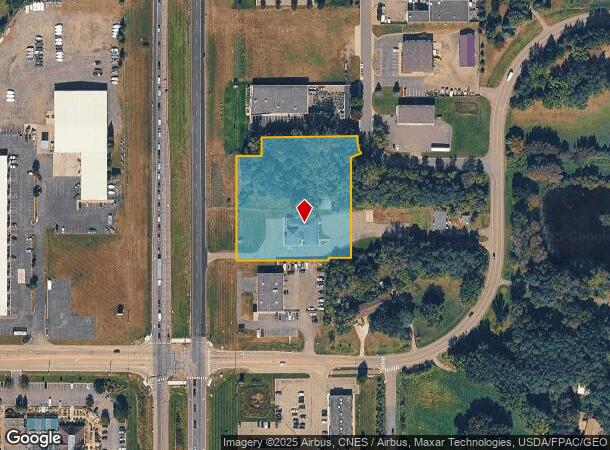
14735 Highway 65 Ne, Andover, MN 55304
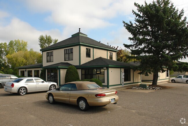
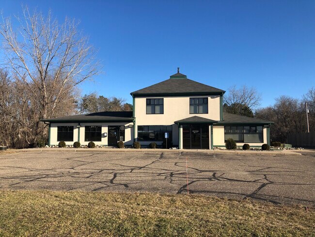
This Property Is For Sale
NEARBY LISTINGS FOR SALE OR LEASE
Property Detail
14735 Highway 65 Ne
Minneapolis-St. Paul-Bloomington, MN-WI
North Pines 3Rd Add
29-32-23-12-0024
LOT 4 BLK 1 NORTH PINES THIRD ADD, TOG/W N 6 FT OF S 290 FT OF W 460.20 FT OF NW1/4 OF NE1/4 OF SEC 29 TWP 32 RGE 23, EX RD,
Commercialnec
Anoka
X
Minnesota
27003C0326E
4
2025
2.40 AC
2025
Anoka County Outlying
050215
Minneapolis/St Paul
6,784 SF
DEMOGRAPHICS near 14735 Highway 65 Ne
1 Mile
3 Mile
5 Mile
2024 Total Population
1,793
25,924
99,183
2029 Population
1,847
26,942
103,401
Pop Growth 2024-2029
+ 3.01%
+ 3.93%
+ 4.25%
Average Age
42
39
39
2024 Total Households
622
8,782
34,208
HH Growth 2024-2029
+ 3.05%
+ 3.84%
+ 4.22%
Median Household Inc
$118,656
$114,635
$109,234
Avg Household Size
2.90
2.90
2.80
2024 Avg HH Vehicles
3.00
2.00
2.00
Median Home Value
$409,783
$363,206
$343,892
Median Year Built
1993
1993
1995
Nearby Places
- Restaurants
- Banks
- Shops
- Fitness
- Groceries
PUBLIC TRANSPORTATION
COMMUTER RAIL
Coon Rapids-Riverdale Station (Northstar Corridor - Northstar Commuter Rail)
DRIVE
WALK
Distance
Coon Rapids-Riverdale Station (Northstar Corridor - Northstar Commuter Rail)
16 min
9.1 mi
AIRPORT
Minneapolis-St Paul International/Wold-Chamberlain
DRIVE
WALK
Distance
Minneapolis-St Paul International/Wold-Chamberlain
46 min
30.9 mi
Nearby Properties
Address
Land Use
TOTAL SIZE
Lot Size
Zoning
Address
Land Use
TOTAL SIZE
Lot Size
Zoning
104,477 SF
18 AC
Address
Land Use
TOTAL SIZE
Lot Size
Zoning
135,994 SF
3.20 AC
Address
Land Use
TOTAL SIZE
Lot Size
Zoning
8,410 SF
12.69 AC
Address
Land Use
TOTAL SIZE
Lot Size
Zoning
76,374 SF
4.91 AC
Address
Land Use
TOTAL SIZE
Lot Size
Zoning
10,912 SF
1.97 AC
Address
Land Use
TOTAL SIZE
Lot Size
Zoning
8,680 SF
8.12 AC
Address
Land Use
TOTAL SIZE
Lot Size
Zoning
70,304 SF
Address
Land Use
TOTAL SIZE
Lot Size
Zoning
Address
Land Use
TOTAL SIZE
Lot Size
Zoning
6,080 SF
20 AC
Address
Land Use
TOTAL SIZE
Lot Size
Zoning
26,719 SF
36.48 AC
Address
Land Use
TOTAL SIZE
Lot Size
Zoning
77,272 SF
3.09 AC
Address
Land Use
TOTAL SIZE
Lot Size
Zoning
74,720 SF
5.24 AC
Address
Land Use
TOTAL SIZE
Lot Size
Zoning
54,272 SF
4.97 AC
Address
Land Use
TOTAL SIZE
Lot Size
Zoning
53,180 SF
30.46 AC
Address
Land Use
TOTAL SIZE
Lot Size
Zoning
58,977 SF
5.65 AC
Address
Land Use
TOTAL SIZE
Lot Size
Zoning
8,204 SF
12.39 AC
Address
Land Use
TOTAL SIZE
Lot Size
Zoning
55,932 SF
5.39 AC
Address
Land Use
TOTAL SIZE
Lot Size
Zoning
24,000 SF
Address
Land Use
TOTAL SIZE
Lot Size
Zoning
1,182 SF
20.50 AC
Address
Land Use
TOTAL SIZE
Lot Size
Zoning
34,970 SF
202.94 AC
Address
Land Use
TOTAL SIZE
Lot Size
Zoning
29,822 SF
2.11 AC
Address
Land Use
TOTAL SIZE
Lot Size
Zoning
32,000 SF
5.25 AC
Address
Land Use
TOTAL SIZE
Lot Size
Zoning
1,586 SF
32.08 AC
Address
Land Use
TOTAL SIZE
Lot Size
Zoning
448 SF
2.28 AC
Address
Land Use
TOTAL SIZE
Lot Size
Zoning
62,624 SF
12 AC
Address
Land Use
TOTAL SIZE
Lot Size
Zoning
1,120 SF
6.02 AC
Address
Land Use
TOTAL SIZE
Lot Size
Zoning
135,883 SF
1.24 AC
Address
Land Use
TOTAL SIZE
Lot Size
Zoning
Address
Land Use
TOTAL SIZE
Lot Size
Zoning
33,992 SF
2.24 AC
The World's #1 Commercial Real Estate Marketplace
Connect with us
© 2025 CoStar Group
The information above has been obtained from sources believed reliable. While we do not doubt its accuracy we have not verified it and make no guarantee, warranty or representation about it. It is your responsibility to independently confirm its accuracy and completeness. Any projections, opinions, assumptions, or estimates used are for example only and do not represent the current or future performance of the property. The value of this transaction to you depends on tax and other factors which should be evaluated by your tax, financial, and legal advisors. You and your advisors should conduct a careful, independent investigation of the property to determine to your satisfaction the suitability of the property for your needs.