Property Record
14740 165Th Ave, Becker, MN 55308


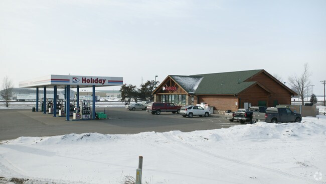
Property Detail
14740 165Th Ave
Minneapolis-St. Paul-Bloomington, MN-WI
THAT PT OF NE 1-4 OF NE 1-4 NELY OF R OF W LINE OF HWY 10 & 52. SUBJ TO EASEMENT DESC AS PARCEL 1 SHERB CTY ROW PLAT 71.
05-016-1105
Sherburne
Conveniencestore
Minnesota
2025
2.03 AC
2025
Sherburne County
030407
Minneapolis/St Paul
3,358 SF
NEARBY LISTINGS FOR SALE OR LEASE
-
-
View all Becker listings for sale on LoopNet.com
DEMOGRAPHICS near 14740 165Th Ave
1 mile
3 mile
5 mile
2025 Total Population
30
7,919
30,620
2030 Population
31
8,197
32,048
Pop Growth 2025-2030
+ 3.33%
+ 3.51%
+ 4.66%
Average Age
35
36
37
2025 Total Households
9
2,704
11,026
HH Growth 2025-2030
+ 11.11%
+ 3.74%
+ 4.91%
Median Household Inc
$131,250
$110,595
$93,851
Avg Household Size
3.20
2.90
2.70
2025 Avg HH Vehicles
3.00
2.00
2.00
Median Home Value
$374,999
$321,842
$326,577
Median Year Built
1999
1995
1994
Nearby Places
Map Layers
Map Styles
 Street
 Aerial
Layers
 Traffic
 Biking
Places
Listings with unknown addresses are not visible on the map
- Restaurants
- Banks
- Shops
- Fitness
- Groceries
PUBLIC TRANSPORTATION
COMMUTER RAIL
Big Lake Station (Northstar Corridor - Northstar Commuter Rail)
Drive
Walk
Distance
Big Lake Station (Northstar Corridor - Northstar Commuter Rail)
11 min
5.6 mi
Freight Ports
Port Milwaukee
Drive
Walk
Distance
Port Milwaukee
423 min
380.2 mi
Nearby Properties
Address
Land Use
TOTAL SIZE
Lot Size
Zoning
Address
Land Use
TOTAL SIZE
Lot Size
Zoning
24,000 SF
394.19 AC
Address
Land Use
TOTAL SIZE
Lot Size
Zoning
114,892 SF
9.38 AC
Address
Land Use
TOTAL SIZE
Lot Size
Zoning
68.67 AC
Address
Land Use
TOTAL SIZE
Lot Size
Zoning
2,440 SF
63.03 AC
Address
Land Use
TOTAL SIZE
Lot Size
Zoning
312 SF
13.63 AC
Address
Land Use
TOTAL SIZE
Lot Size
Zoning
262.30 AC
Address
Land Use
TOTAL SIZE
Lot Size
Zoning
7,644 SF
13.85 AC
I
Address
Land Use
TOTAL SIZE
Lot Size
Zoning
26.75 AC
Address
Land Use
TOTAL SIZE
Lot Size
Zoning
17,028 SF
5.75 AC
Address
Land Use
TOTAL SIZE
Lot Size
Zoning
1,686 SF
2.51 AC
Address
Land Use
TOTAL SIZE
Lot Size
Zoning
35,674 SF
4.63 AC
Address
Land Use
TOTAL SIZE
Lot Size
Zoning
195.70 AC
Address
Land Use
TOTAL SIZE
Lot Size
Zoning
5,600 SF
1.92 AC
Address
Land Use
TOTAL SIZE
Lot Size
Zoning
2,464 SF
5 AC
I
Address
Land Use
TOTAL SIZE
Lot Size
Zoning
19,200 SF
4.62 AC
Address
Land Use
TOTAL SIZE
Lot Size
Zoning
11,904 SF
11.26 AC
Address
Land Use
TOTAL SIZE
Lot Size
Zoning
7,268 SF
6.01 AC
Address
Land Use
TOTAL SIZE
Lot Size
Zoning
20,000 SF
2.66 AC
Address
Land Use
TOTAL SIZE
Lot Size
Zoning
1,800 SF
39.52 AC
I
Address
Land Use
TOTAL SIZE
Lot Size
Zoning
157.61 AC
Address
Land Use
TOTAL SIZE
Lot Size
Zoning
18,436 SF
1.99 AC
Address
Land Use
TOTAL SIZE
Lot Size
Zoning
20,000 SF
3.86 AC
Address
Land Use
TOTAL SIZE
Lot Size
Zoning
3,650 SF
1.11 AC
Address
Land Use
TOTAL SIZE
Lot Size
Zoning
1,380 SF
1.25 AC
Address
Land Use
TOTAL SIZE
Lot Size
Zoning
672 SF
40 AC
Address
Land Use
TOTAL SIZE
Lot Size
Zoning
2,760 SF
1.25 AC
Address
Land Use
TOTAL SIZE
Lot Size
Zoning
2,157 SF
17.60 AC
I
Address
Land Use
TOTAL SIZE
Lot Size
Zoning
1,138 SF
55.44 AC
A
Address
Land Use
TOTAL SIZE
Lot Size
Zoning
91.55 AC
The World's #1 Commercial Real Estate Marketplace
Connect with us
© 2026 CoStar Group
The information above has been obtained from sources believed reliable. While we do not doubt its accuracy we have not verified it and make no guarantee, warranty or representation about it. It is your responsibility to independently confirm its accuracy and completeness. Any projections, opinions, assumptions, or estimates used are for example only and do not represent the current or future performance of the property. The value of this transaction to you depends on tax and other factors which should be evaluated by your tax, financial, and legal advisors. You and your advisors should conduct a careful, independent investigation of the property to determine to your satisfaction the suitability of the property for your needs.