Property Record
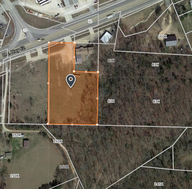
14753 Highway 62, Rogers, AR 72756


NEARBY LISTINGS FOR SALE OR LEASE
Property Detail
14753 Highway 62
18-04267-000
Rural
Publicstorage
PART OF THE SE 1/4 OF THE SW 1/4 OF SECTION 3, TOWNSHIP 20 NORTH, RANGE 29 WEST, BENTON COUNTY, ARKANSAS, BEING MORE PARTICULARLY DESCRIBED AS FOLLOWS: COMMENCING AT AN EXISTING REBAR MARKING THE NE CORNER OF THE SE 1/4 OF THE SW 1/4; THENCE ALONG TH
X
Benton
29119C0475D
Arkansas
2025
2.44 AC
2025
Outlying Benton County
020203
Fayetteville/Springdale/Rogers
3,600 SF
Fayetteville-Springdale-Rogers, AR-MO
DEMOGRAPHICS near 14753 Highway 62
1 Mile
3 Mile
5 Mile
2024 Total Population
435
3,572
17,037
2029 Population
513
4,236
20,215
Pop Growth 2024-2029
+ 17.93%
+ 18.59%
+ 18.65%
Average Age
41
40
39
2024 Total Households
160
1,262
6,013
HH Growth 2024-2029
+ 17.50%
+ 18.62%
+ 18.68%
Median Household Inc
$71,249
$69,124
$78,786
Avg Household Size
2.70
2.70
2.80
2024 Avg HH Vehicles
3.00
3.00
2.00
Median Home Value
$189,999
$230,651
$229,731
Median Year Built
1990
1993
1994
Nearby Places
Map Layers
Map Styles
 Street
 Aerial
- Restaurants
- Banks
- Shops
- Fitness
- Groceries
PUBLIC TRANSPORTATION
AIRPORT
Northwest Arkansas Ntl
DRIVE
WALK
Distance
Northwest Arkansas Ntl
42 min
22.7 mi
Freight Ports
Tulsa Port of Inola
DRIVE
WALK
Distance
Tulsa Port of Inola
128 min
108.0 mi
Nearby Properties
Address
Land Use
TOTAL SIZE
Lot Size
Zoning
Address
Land Use
TOTAL SIZE
Lot Size
Zoning
58,990 SF
5.70 AC
Address
Land Use
TOTAL SIZE
Lot Size
Zoning
120.12 AC
Address
Land Use
TOTAL SIZE
Lot Size
Zoning
39,805 SF
6.77 AC
Address
Land Use
TOTAL SIZE
Lot Size
Zoning
4,900 SF
10.56 AC
Address
Land Use
TOTAL SIZE
Lot Size
Zoning
100 AC
Address
Land Use
TOTAL SIZE
Lot Size
Zoning
40,000 SF
4.90 AC
Address
Land Use
TOTAL SIZE
Lot Size
Zoning
57.90 AC
Address
Land Use
TOTAL SIZE
Lot Size
Zoning
17,666 SF
3.08 AC
Address
Land Use
TOTAL SIZE
Lot Size
Zoning
9,301 SF
1.13 AC
Address
Land Use
TOTAL SIZE
Lot Size
Zoning
13,724 SF
2.05 AC
Address
Land Use
TOTAL SIZE
Lot Size
Zoning
2,490 SF
2.30 AC
Address
Land Use
TOTAL SIZE
Lot Size
Zoning
6,440 SF
3.15 AC
Address
Land Use
TOTAL SIZE
Lot Size
Zoning
931 SF
17.43 AC
Address
Land Use
TOTAL SIZE
Lot Size
Zoning
39.98 AC
Address
Land Use
TOTAL SIZE
Lot Size
Zoning
5,615 SF
0.52 AC
Address
Land Use
TOTAL SIZE
Lot Size
Zoning
39.07 AC
Address
Land Use
TOTAL SIZE
Lot Size
Zoning
5,440 SF
1.74 AC
Address
Land Use
TOTAL SIZE
Lot Size
Zoning
5,000 SF
2.17 AC
Address
Land Use
TOTAL SIZE
Lot Size
Zoning
1,446 SF
32.50 AC
Address
Land Use
TOTAL SIZE
Lot Size
Zoning
5,735 SF
1.26 AC
Address
Land Use
TOTAL SIZE
Lot Size
Zoning
8,096 SF
1.13 AC
Address
Land Use
TOTAL SIZE
Lot Size
Zoning
7,848 SF
0.83 AC
Address
Land Use
TOTAL SIZE
Lot Size
Zoning
3,620 SF
0.73 AC
Address
Land Use
TOTAL SIZE
Lot Size
Zoning
6,000 SF
3.75 AC
Address
Land Use
TOTAL SIZE
Lot Size
Zoning
5,000 SF
1.33 AC
Address
Land Use
TOTAL SIZE
Lot Size
Zoning
575 SF
0.35 AC
Address
Land Use
TOTAL SIZE
Lot Size
Zoning
7,200 SF
2.57 AC
Address
Land Use
TOTAL SIZE
Lot Size
Zoning
5,000 SF
3 AC
Address
Land Use
TOTAL SIZE
Lot Size
Zoning
3,750 SF
1.09 AC
Address
Land Use
TOTAL SIZE
Lot Size
Zoning
2,906 SF
1.01 AC
The World's #1 Commercial Real Estate Marketplace
Connect with us
© 2026 CoStar Group
The information above has been obtained from sources believed reliable. While we do not doubt its accuracy we have not verified it and make no guarantee, warranty or representation about it. It is your responsibility to independently confirm its accuracy and completeness. Any projections, opinions, assumptions, or estimates used are for example only and do not represent the current or future performance of the property. The value of this transaction to you depends on tax and other factors which should be evaluated by your tax, financial, and legal advisors. You and your advisors should conduct a careful, independent investigation of the property to determine to your satisfaction the suitability of the property for your needs.