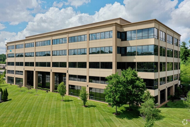
Property Record
14755 N North Outer 40 Rd, Chesterfield, MO 63017

Current Lease Availabilities
NEARBY LISTINGS FOR SALE OR LEASE
Property Detail
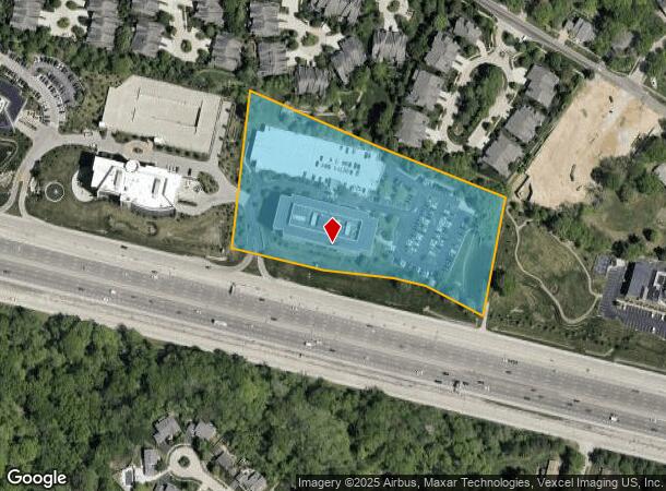
14755 N North Outer 40 Rd
St. Louis, MO-IL
Highland On Conway Plat 1
18R-11-0011
HIGHLAND ON CONWAY PLAT 1 LOT PT 8 N PT
Officebuilding
St. Louis
X
Missouri
29183C0470G
8
2024
6.44 AC
2025
Chesterfield/Hwy-40
215235
St. Louis
153,316 SF
DEMOGRAPHICS near 14755 N North Outer 40 Rd
1 Mile
3 Mile
5 Mile
2024 Total Population
8,543
53,615
121,481
2029 Population
8,374
52,584
118,994
Pop Growth 2024-2029
(1.98%)
(1.92%)
(2.05%)
Average Age
46
45
43
2024 Total Households
3,339
21,036
47,757
HH Growth 2024-2029
(2.01%)
(1.92%)
(2.08%)
Median Household Inc
$131,084
$129,299
$117,865
Avg Household Size
2.40
2.40
2.50
2024 Avg HH Vehicles
2.00
2.00
2.00
Median Home Value
$394,409
$418,464
$384,066
Median Year Built
1978
1979
1977
Nearby Places
Map Layers
Map Styles
 Street
 Aerial
- Restaurants
- Banks
- Shops
- Fitness
- Groceries
PUBLIC TRANSPORTATION
AIRPORT
St Louis Lambert International
DRIVE
WALK
Distance
St Louis Lambert International
31 min
20.9 mi
Nearby Properties
Address
Land Use
TOTAL SIZE
Lot Size
Zoning
Address
Land Use
TOTAL SIZE
Lot Size
Zoning
200,372 SF
121.45 AC
105FPNU
Address
Land Use
TOTAL SIZE
Lot Size
Zoning
43,574 SF
55.62 AC
NU
Address
Land Use
TOTAL SIZE
Lot Size
Zoning
8.21 AC
105C8
Address
Land Use
TOTAL SIZE
Lot Size
Zoning
1,298,224 SF
194.08 AC
C-8
Address
Land Use
TOTAL SIZE
Lot Size
Zoning
420,140 SF
16.49 AC
105C8
Address
Land Use
TOTAL SIZE
Lot Size
Zoning
462,876 SF
12.89 AC
105R8
Address
Land Use
TOTAL SIZE
Lot Size
Zoning
157,315 SF
41.71 AC
105C8
Address
Land Use
TOTAL SIZE
Lot Size
Zoning
587,809 SF
36.69 AC
105NU
Address
Land Use
TOTAL SIZE
Lot Size
Zoning
352,152 SF
31.79 AC
105C8
Address
Land Use
TOTAL SIZE
Lot Size
Zoning
12,017 SF
122.40 AC
NU
Address
Land Use
TOTAL SIZE
Lot Size
Zoning
Address
Land Use
TOTAL SIZE
Lot Size
Zoning
247,860 SF
21.11 AC
105MU
Address
Land Use
TOTAL SIZE
Lot Size
Zoning
272,522 SF
8.70 AC
83POP
Address
Land Use
TOTAL SIZE
Lot Size
Zoning
68,279 SF
95.59 AC
NU
Address
Land Use
TOTAL SIZE
Lot Size
Zoning
70.42 AC
87A
Address
Land Use
TOTAL SIZE
Lot Size
Zoning
65.15 AC
105NU
Address
Land Use
TOTAL SIZE
Lot Size
Zoning
340,320 SF
55.62 AC
NU
Address
Land Use
TOTAL SIZE
Lot Size
Zoning
302,420 SF
13.97 AC
NU
Address
Land Use
TOTAL SIZE
Lot Size
Zoning
1,635 SF
68.83 AC
83E
Address
Land Use
TOTAL SIZE
Lot Size
Zoning
218,130 SF
7.31 AC
105PC&R
Address
Land Use
TOTAL SIZE
Lot Size
Zoning
363,584 SF
48.15 AC
FPNU
Address
Land Use
TOTAL SIZE
Lot Size
Zoning
200,840 SF
12.29 AC
105C8
Address
Land Use
TOTAL SIZE
Lot Size
Zoning
344,386 SF
41.26 AC
R2
Address
Land Use
TOTAL SIZE
Lot Size
Zoning
60,928 SF
102.43 AC
NU
Address
Land Use
TOTAL SIZE
Lot Size
Zoning
359,937 SF
26.91 AC
R4
Address
Land Use
TOTAL SIZE
Lot Size
Zoning
42,037 SF
193.91 AC
NU
Address
Land Use
TOTAL SIZE
Lot Size
Zoning
242,380 SF
12.60 AC
105PC&R
Address
Land Use
TOTAL SIZE
Lot Size
Zoning
288,733 SF
36.80 AC
R5
Address
Land Use
TOTAL SIZE
Lot Size
Zoning
146,175 SF
1.41 AC
83POP
Address
Land Use
TOTAL SIZE
Lot Size
Zoning
201,837 SF
27.89 AC
83C
The World's #1 Commercial Real Estate Marketplace
Connect with us
© 2026 CoStar Group
The information above has been obtained from sources believed reliable. While we do not doubt its accuracy we have not verified it and make no guarantee, warranty or representation about it. It is your responsibility to independently confirm its accuracy and completeness. Any projections, opinions, assumptions, or estimates used are for example only and do not represent the current or future performance of the property. The value of this transaction to you depends on tax and other factors which should be evaluated by your tax, financial, and legal advisors. You and your advisors should conduct a careful, independent investigation of the property to determine to your satisfaction the suitability of the property for your needs.