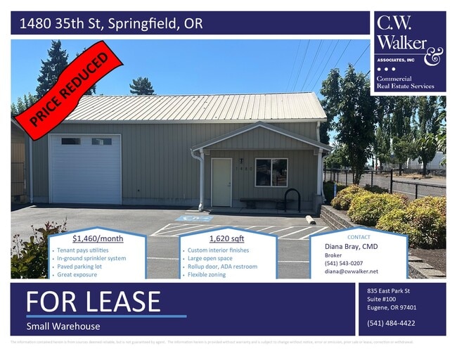
Property Record
1480 35Th St, Springfield, OR 97478
Current Lease Availabilities
NEARBY LISTINGS FOR SALE OR LEASE
-
-
View all Springfield listings for lease on LoopNet.com
Property Detail
1480 35Th St
Eugene, OR
First Addition To Adams Plat
0115202
Lane
Sfr
Oregon
X
0.27 AC
41039C1161F
Lane County
1,000 SF
Portland
DEMOGRAPHICS near 1480 35Th St
1 Mile
3 Mile
5 Mile
2024 Total Population
7,880
51,530
103,428
2029 Population
7,882
51,030
102,755
Pop Growth 2024-2029
+ 0.03%
(0.97%)
(0.65%)
Average Age
39
40
39
2024 Total Households
3,018
20,692
40,482
HH Growth 2024-2029
+ 0.10%
(1.09%)
(0.79%)
Median Household Inc
$72,671
$68,590
$70,204
Avg Household Size
2.50
2.40
2.40
2024 Avg HH Vehicles
2.00
2.00
2.00
Median Home Value
$373,180
$358,903
$412,057
Median Year Built
1972
1972
1976
Nearby Places
- Restaurants
- Banks
- Shops
- Fitness
- Groceries
PUBLIC TRANSPORTATION
COMMUTER RAIL
Eugene (Amtrak Cascades - Amtrak, Coast Starlight - Amtrak)
DRIVE
WALK
Distance
Eugene (Amtrak Cascades - Amtrak, Coast Starlight - Amtrak)
10 min
6.6 mi
AIRPORT
Mahlon Sweet Field
DRIVE
WALK
Distance
Mahlon Sweet Field
25 min
15.1 mi
Freight Ports
Port of Coos Bay, OR
DRIVE
WALK
Distance
Port of Coos Bay, OR
161 min
115.1 mi
Nearby Properties
Address
Land Use
TOTAL SIZE
Lot Size
Zoning
Address
Land Use
TOTAL SIZE
Lot Size
Zoning
Address
Land Use
TOTAL SIZE
Lot Size
Zoning
9.57 AC
LD
Address
Land Use
TOTAL SIZE
Lot Size
Zoning
179 AC
E30
Address
Land Use
TOTAL SIZE
Lot Size
Zoning
33.20 AC
HI
Address
Land Use
TOTAL SIZE
Lot Size
Zoning
22.52 AC
LD
Address
Land Use
TOTAL SIZE
Lot Size
Zoning
Address
Land Use
TOTAL SIZE
Lot Size
Zoning
Address
Land Use
TOTAL SIZE
Lot Size
Zoning
11.23 AC
Address
Land Use
TOTAL SIZE
Lot Size
Zoning
Address
Land Use
TOTAL SIZE
Lot Size
Zoning
Address
Land Use
TOTAL SIZE
Lot Size
Zoning
50.28 AC
LD
Address
Land Use
TOTAL SIZE
Lot Size
Zoning
28.66 AC
LMI
Address
Land Use
TOTAL SIZE
Lot Size
Zoning
19.48 AC
LD
Address
Land Use
TOTAL SIZE
Lot Size
Zoning
35.91 AC
HI
Address
Land Use
TOTAL SIZE
Lot Size
Zoning
27.44 AC
LD
Address
Land Use
TOTAL SIZE
Lot Size
Zoning
Address
Land Use
TOTAL SIZE
Lot Size
Zoning
15.54 AC
HI
Address
Land Use
TOTAL SIZE
Lot Size
Zoning
15.15 AC
LD
Address
Land Use
TOTAL SIZE
Lot Size
Zoning
11.12 AC
HI
Address
Land Use
TOTAL SIZE
Lot Size
Zoning
10.70 AC
LD
Address
Land Use
TOTAL SIZE
Lot Size
Zoning
9.19 AC
E25
Address
Land Use
TOTAL SIZE
Lot Size
Zoning
9.40 AC
LD
Address
Land Use
TOTAL SIZE
Lot Size
Zoning
3.58 AC
HD
Address
Land Use
TOTAL SIZE
Lot Size
Zoning
0.99 AC
MUC
Address
Land Use
TOTAL SIZE
Lot Size
Zoning
18.78 AC
LD
Address
Land Use
TOTAL SIZE
Lot Size
Zoning
13.84 AC
HD
Address
Land Use
TOTAL SIZE
Lot Size
Zoning
57.39 AC
CC
Address
Land Use
TOTAL SIZE
Lot Size
Zoning
9.23 AC
LD
Address
Land Use
TOTAL SIZE
Lot Size
Zoning
18.70 AC
E30
Address
Land Use
TOTAL SIZE
Lot Size
Zoning
7.06 AC
HI
The World's #1 Commercial Real Estate Marketplace
Connect with us
© 2025 CoStar Group
The information above has been obtained from sources believed reliable. While we do not doubt its accuracy we have not verified it and make no guarantee, warranty or representation about it. It is your responsibility to independently confirm its accuracy and completeness. Any projections, opinions, assumptions, or estimates used are for example only and do not represent the current or future performance of the property. The value of this transaction to you depends on tax and other factors which should be evaluated by your tax, financial, and legal advisors. You and your advisors should conduct a careful, independent investigation of the property to determine to your satisfaction the suitability of the property for your needs.