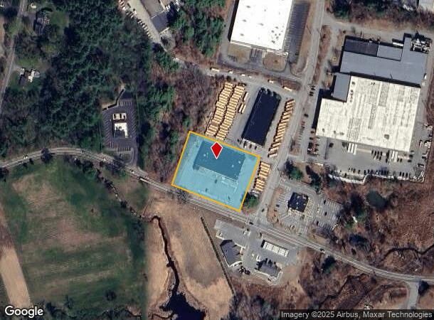
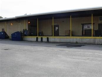
Property Record
1480 Broadway Rd, Dracut, MA 01826

NEARBY LISTINGS FOR SALE OR LEASE
-
-
View all Dracut listings for sale on LoopNet.com
Property Detail
1480 Broadway Rd
DRAC-000008-000019-000015
Middlesex
Departmentstore
Massachusetts
X
15
25017C0135F
1.56 AC
2025
Groton/Townsend
2025
Boston
314302
Boston-Cambridge-Newton, MA-NH
15,867 SF
DEMOGRAPHICS near 1480 Broadway Rd
1 Mile
3 Mile
5 Mile
2024 Total Population
1,720
28,054
177,947
2029 Population
1,722
28,006
175,444
Pop Growth 2024-2029
+ 0.12%
(0.17%)
(1.41%)
Average Age
41
42
39
2024 Total Households
544
9,942
63,325
HH Growth 2024-2029
+ 0.18%
(0.32%)
(1.32%)
Median Household Inc
$138,124
$113,262
$72,749
Avg Household Size
3.10
2.80
2.70
2024 Avg HH Vehicles
3.00
2.00
2.00
Median Home Value
$600,682
$497,687
$424,557
Median Year Built
1985
1976
1962
Nearby Places
Map Layers
Map Styles
 Street
 Aerial
- Restaurants
- Banks
- Shops
- Fitness
- Groceries
PUBLIC TRANSPORTATION
COMMUTER RAIL
Lawrence (Haverhill Line - Massachusetts Bay Transportation Authority Commuter Rail (Purple Line))
DRIVE
WALK
Distance
Lawrence (Haverhill Line - Massachusetts Bay Transportation Authority Commuter Rail (Purple Line))
13 min
6.1 mi
Lowell (Lowell Line - Massachusetts Bay Transportation Authority Commuter Rail (Purple Line))
DRIVE
WALK
Distance
Lowell (Lowell Line - Massachusetts Bay Transportation Authority Commuter Rail (Purple Line))
14 min
6.5 mi
AIRPORT
Manchester Boston Regional
DRIVE
WALK
Distance
Manchester Boston Regional
41 min
27.0 mi
General Edward Lawrence Logan International
DRIVE
WALK
Distance
General Edward Lawrence Logan International
42 min
30.8 mi
Portsmouth International at Pease
DRIVE
WALK
Distance
Portsmouth International at Pease
58 min
43.3 mi
Freight Ports
Port of Boston
DRIVE
WALK
Distance
Port of Boston
43 min
30.6 mi
SALE & LEASE HISTORY
LISTING DATE
SALE/LEASE

Oct 13, 2017
For Sale
Aug 17, 2017
For Sale
Nearby Properties
Address
Land Use
TOTAL SIZE
Lot Size
Zoning
Address
Land Use
TOTAL SIZE
Lot Size
Zoning
52.02 AC
ID
Address
Land Use
TOTAL SIZE
Lot Size
Zoning
309.16 AC
ID2
Address
Land Use
TOTAL SIZE
Lot Size
Zoning
144.01 AC
ID
Address
Land Use
TOTAL SIZE
Lot Size
Zoning
382,753 SF
25.86 AC
ID2
Address
Land Use
TOTAL SIZE
Lot Size
Zoning
803 SF
3.29 AC
R1
Address
Land Use
TOTAL SIZE
Lot Size
Zoning
96.66 AC
ID
Address
Land Use
TOTAL SIZE
Lot Size
Zoning
210,192 SF
15.06 AC
CN
Address
Land Use
TOTAL SIZE
Lot Size
Zoning
196,152 SF
20.20 AC
ID2
Address
Land Use
TOTAL SIZE
Lot Size
Zoning
130.08 AC
ID2
Address
Land Use
TOTAL SIZE
Lot Size
Zoning
105,949 SF
28.24 AC
ID2
Address
Land Use
TOTAL SIZE
Lot Size
Zoning
162,978 SF
13.73 AC
ID2
Address
Land Use
TOTAL SIZE
Lot Size
Zoning
150,292 SF
22.77 AC
ID2
Address
Land Use
TOTAL SIZE
Lot Size
Zoning
234,000 SF
17.55 AC
IL
Address
Land Use
TOTAL SIZE
Lot Size
Zoning
27.15 AC
ID
Address
Land Use
TOTAL SIZE
Lot Size
Zoning
322,858 SF
15.97 AC
ID
Address
Land Use
TOTAL SIZE
Lot Size
Zoning
9.10 AC
MB
Address
Land Use
TOTAL SIZE
Lot Size
Zoning
124,760 SF
13.51 AC
ID
Address
Land Use
TOTAL SIZE
Lot Size
Zoning
17.52 AC
BH
Address
Land Use
TOTAL SIZE
Lot Size
Zoning
127,448 SF
13.14 AC
ID
Address
Land Use
TOTAL SIZE
Lot Size
Zoning
288,106 SF
20.73 AC
IL
Address
Land Use
TOTAL SIZE
Lot Size
Zoning
114,785 SF
8.51 AC
ID
Address
Land Use
TOTAL SIZE
Lot Size
Zoning
127,920 SF
18.13 AC
IL
Address
Land Use
TOTAL SIZE
Lot Size
Zoning
90,404 SF
6 AC
ID
Address
Land Use
TOTAL SIZE
Lot Size
Zoning
121,615 SF
9.62 AC
ID2
Address
Land Use
TOTAL SIZE
Lot Size
Zoning
105,902 SF
8.09 AC
ID
Address
Land Use
TOTAL SIZE
Lot Size
Zoning
125,896 SF
9.41 AC
ID
Address
Land Use
TOTAL SIZE
Lot Size
Zoning
27.16 AC
ID2
Address
Land Use
TOTAL SIZE
Lot Size
Zoning
120,807 SF
11 AC
R1
Address
Land Use
TOTAL SIZE
Lot Size
Zoning
88,056 SF
43.67 AC
ID2
Address
Land Use
TOTAL SIZE
Lot Size
Zoning
95,496 SF
5.75 AC
BH
The World's #1 Commercial Real Estate Marketplace
Connect with us
© 2026 CoStar Group
The information above has been obtained from sources believed reliable. While we do not doubt its accuracy we have not verified it and make no guarantee, warranty or representation about it. It is your responsibility to independently confirm its accuracy and completeness. Any projections, opinions, assumptions, or estimates used are for example only and do not represent the current or future performance of the property. The value of this transaction to you depends on tax and other factors which should be evaluated by your tax, financial, and legal advisors. You and your advisors should conduct a careful, independent investigation of the property to determine to your satisfaction the suitability of the property for your needs.