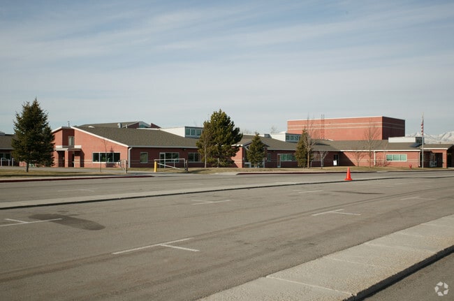
Property Record
1480 E 9400 S, Sandy, UT 84093
Property Detail
1480 E 9400 S
28-09-103-003-0000
BEG N 89^5328 E 1312.37 FT & S 0^1323 W 33 FT & N 89^5328 E 50 FT & S 0^1323 W 40 FT FR NW COR SEC 9, T 3S, R 1E, SLM; N 89^4944 E 619.77 FT; S 0^1323 W 578.04 FT M OR L; S 89^5328 W 669.77 FT TO W LINE OF NE 1/4 OF NW1/4; N 0^1327 E 535.37 FT; N 89^
Publicschool
Salt Lake
PO
Utah
B and X Area of moderate flood hazard, usually the area between the limits of the 100-year and 500-year floods.
7.28 AC
0
Southeast Valley
2025
Salt Lake City
112613
Salt Lake City-Murray, UT
56,934 SF
NEARBY LISTINGS FOR SALE OR LEASE
DEMOGRAPHICS near 1480 E 9400 S
1 mile
3 mile
5 mile
2025 Total Population
14,272
122,132
249,378
2030 Population
14,367
124,272
254,915
Pop Growth 2025-2030
+ 0.67%
+ 1.75%
+ 2.22%
Average Age
40
40
39
2025 Total Households
4,748
42,820
89,527
HH Growth 2025-2030
+ 0.78%
+ 1.92%
+ 2.40%
Median Household Inc
$119,619
$111,329
$106,359
Avg Household Size
3.00
2.80
2.70
2025 Avg HH Vehicles
2.00
2.00
2.00
Median Home Value
$644,787
$676,747
$677,422
Median Year Built
1977
1982
1986
Nearby Places
Map Layers
Map Styles
 Street
 Aerial
Transit
 Traffic
 Biking
Places
Listings with unknown addresses are not visible on the map
- Restaurants
- Banks
- Shops
- Fitness
- Groceries
PUBLIC TRANSPORTATION
COMMUTER RAIL
South Jordan Station (FrontRunner - Utah Transit Authority (UTA))
Drive
Walk
Distance
South Jordan Station (FrontRunner - Utah Transit Authority (UTA))
10 min
4.6 mi
Draper Station (FrontRunner - Utah Transit Authority (UTA))
Drive
Walk
Distance
Draper Station (FrontRunner - Utah Transit Authority (UTA))
17 min
8.3 mi
AIRPORT
Salt Lake City International
Drive
Walk
Distance
Salt Lake City International
29 min
20.8 mi
Provo Municipal
Drive
Walk
Distance
Provo Municipal
50 min
35.6 mi
Freight Ports
Port of Stockton
Drive
Walk
Distance
Port of Stockton
729 min
707.6 mi
Nearby Properties
Address
Land Use
TOTAL SIZE
Lot Size
Zoning
Address
Land Use
TOTAL SIZE
Lot Size
Zoning
257,906 SF
36.42 AC
1110
Address
Land Use
TOTAL SIZE
Lot Size
Zoning
235,963 SF
35.56 AC
SF1-DO
Address
Land Use
TOTAL SIZE
Lot Size
Zoning
512,301 SF
25.39 AC
SD(H)
Address
Land Use
TOTAL SIZE
Lot Size
Zoning
258,000 SF
13.25 AC
1D
Address
Land Use
TOTAL SIZE
Lot Size
Zoning
552,994 SF
13.64 AC
SD-X
Address
Land Use
TOTAL SIZE
Lot Size
Zoning
186,717 SF
21.58 AC
RM
Address
Land Use
TOTAL SIZE
Lot Size
Zoning
566,327 SF
7.02 AC
CBD-O
Address
Land Use
TOTAL SIZE
Lot Size
Zoning
458,458 SF
6.05 AC
MU
Address
Land Use
TOTAL SIZE
Lot Size
Zoning
224,049 SF
5.29 AC
MU
Address
Land Use
TOTAL SIZE
Lot Size
Zoning
500,249 SF
3.16 AC
MU
Address
Land Use
TOTAL SIZE
Lot Size
Zoning
106,318 SF
4.46 AC
CBD-O
Address
Land Use
TOTAL SIZE
Lot Size
Zoning
500,249 SF
3.16 AC
MU
Address
Land Use
TOTAL SIZE
Lot Size
Zoning
398,320 SF
40 AC
1110
Address
Land Use
TOTAL SIZE
Lot Size
Zoning
124,434 SF
13.64 AC
PUD-15
Address
Land Use
TOTAL SIZE
Lot Size
Zoning
280,668 SF
12 AC
CBD
Address
Land Use
TOTAL SIZE
Lot Size
Zoning
143,600 SF
7.56 AC
2000
Address
Land Use
TOTAL SIZE
Lot Size
Zoning
327,940 SF
3.95 AC
SD
Address
Land Use
TOTAL SIZE
Lot Size
Zoning
103,114 SF
14.82 AC
RM 25
Address
Land Use
TOTAL SIZE
Lot Size
Zoning
327,940 SF
3.37 AC
SD
Address
Land Use
TOTAL SIZE
Lot Size
Zoning
379,911 SF
5.78 AC
mu
Address
Land Use
TOTAL SIZE
Lot Size
Zoning
551,648 SF
31.71 AC
C B D
Address
Land Use
TOTAL SIZE
Lot Size
Zoning
176,826 SF
6.13 AC
SD(H)
Address
Land Use
TOTAL SIZE
Lot Size
Zoning
198,479 SF
2.52 AC
MU
Address
Land Use
TOTAL SIZE
Lot Size
Zoning
422,482 SF
3.42 AC
RC
Address
Land Use
TOTAL SIZE
Lot Size
Zoning
185,116 SF
14.49 AC
PUD-10
Address
Land Use
TOTAL SIZE
Lot Size
Zoning
106,016 SF
32.73 AC
1108
Address
Land Use
TOTAL SIZE
Lot Size
Zoning
131,979 SF
12.38 AC
PUD15
Address
Land Use
TOTAL SIZE
Lot Size
Zoning
3,867 SF
2.20 AC
1144
Address
Land Use
TOTAL SIZE
Lot Size
Zoning
328,268 SF
13.37 AC
SDJHS
Address
Land Use
TOTAL SIZE
Lot Size
Zoning
470,856 SF
10.74 AC
CBDO
The World's #1 Commercial Real Estate Marketplace
Connect with us
© 2026 CoStar Group
The information above has been obtained from sources believed reliable. While we do not doubt its accuracy we have not verified it and make no guarantee, warranty or representation about it. It is your responsibility to independently confirm its accuracy and completeness. Any projections, opinions, assumptions, or estimates used are for example only and do not represent the current or future performance of the property. The value of this transaction to you depends on tax and other factors which should be evaluated by your tax, financial, and legal advisors. You and your advisors should conduct a careful, independent investigation of the property to determine to your satisfaction the suitability of the property for your needs.