Property Record
14800 County Road 5, Burnsville, MN 55306


NEARBY LISTINGS FOR SALE OR LEASE
-
-
View all Burnsville listings for sale on LoopNet.com
Property Detail
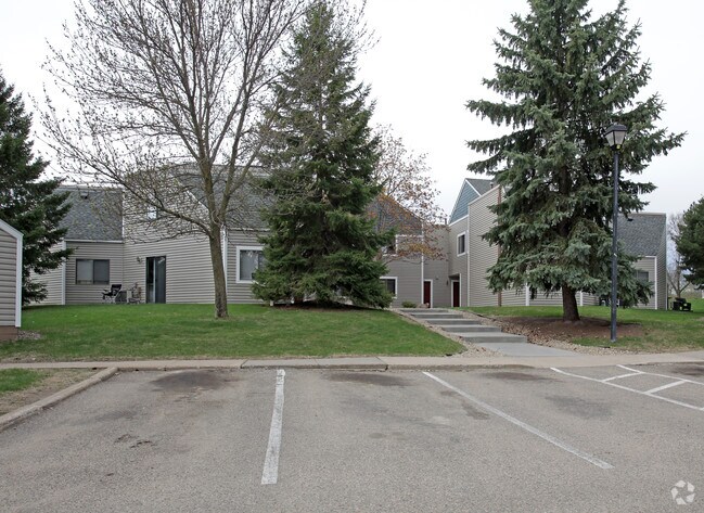
14800 County Road 5
Minneapolis-St. Paul-Bloomington, MN-WI
Registered Land Survey #26
02-90260-00-072
G PT OF TRACT G BEG SE COR W ALONG S LINE 640.71 FT N 13D 02M 26S W 345 FT N 77D 21M24S E 198.45 FT S 86D43M 44S E 127.02 FT S 79D37M35S E 129.26 FT N 75D19M15S E 180.60 FT TO E LINE S ALONG E LINE 432.68 FT TO BEG REGISTERED LAND SURVEY #26
Apartment
Dakota
X
Minnesota
27037C0181E
72
2023
5.60 AC
2024
Dakota Far Southwest Suburbs
060739
Minneapolis/St Paul
63,735 SF
DEMOGRAPHICS near 14800 County Road 5
1 Mile
3 Mile
5 Mile
2024 Total Population
7,750
71,068
168,445
2029 Population
7,859
73,019
173,350
Pop Growth 2024-2029
+ 1.41%
+ 2.75%
+ 2.91%
Average Age
39
39
39
2024 Total Households
3,297
26,394
62,975
HH Growth 2024-2029
+ 1.36%
+ 2.73%
+ 2.98%
Median Household Inc
$77,959
$94,552
$97,527
Avg Household Size
2.30
2.60
2.60
2024 Avg HH Vehicles
2.00
2.00
2.00
Median Home Value
$334,151
$329,089
$341,720
Median Year Built
1987
1984
1988
Nearby Places
Map Layers
Map Styles
 Street
 Aerial
- Restaurants
- Banks
- Shops
- Fitness
- Groceries
PUBLIC TRANSPORTATION
AIRPORT
Minneapolis-St Paul International/Wold-Chamberlain
DRIVE
WALK
Distance
Minneapolis-St Paul International/Wold-Chamberlain
24 min
15.0 mi
Freight Ports
Port Milwaukee
DRIVE
WALK
Distance
Port Milwaukee
386 min
347.5 mi
Nearby Properties
Address
Land Use
TOTAL SIZE
Lot Size
Zoning
Address
Land Use
TOTAL SIZE
Lot Size
Zoning
339,871 SF
26.64 AC
Address
Land Use
TOTAL SIZE
Lot Size
Zoning
525,323 SF
8.09 AC
Address
Land Use
TOTAL SIZE
Lot Size
Zoning
519,392 SF
17.66 AC
Address
Land Use
TOTAL SIZE
Lot Size
Zoning
584,692 SF
15.70 AC
Address
Land Use
TOTAL SIZE
Lot Size
Zoning
230,883 SF
2.49 AC
Address
Land Use
TOTAL SIZE
Lot Size
Zoning
268,116 SF
7.81 AC
Address
Land Use
TOTAL SIZE
Lot Size
Zoning
8.70 AC
Address
Land Use
TOTAL SIZE
Lot Size
Zoning
24,750 SF
14.36 AC
Address
Land Use
TOTAL SIZE
Lot Size
Zoning
394,700 SF
13.23 AC
Address
Land Use
TOTAL SIZE
Lot Size
Zoning
419,750 SF
13.83 AC
Address
Land Use
TOTAL SIZE
Lot Size
Zoning
289,168 SF
11.73 AC
Address
Land Use
TOTAL SIZE
Lot Size
Zoning
265,406 SF
26.78 AC
Address
Land Use
TOTAL SIZE
Lot Size
Zoning
273,843 SF
17.55 AC
Address
Land Use
TOTAL SIZE
Lot Size
Zoning
177,489 SF
1.75 AC
Address
Land Use
TOTAL SIZE
Lot Size
Zoning
276,290 SF
7.44 AC
Address
Land Use
TOTAL SIZE
Lot Size
Zoning
216,267 SF
3.69 AC
Address
Land Use
TOTAL SIZE
Lot Size
Zoning
234,348 SF
11.21 AC
Address
Land Use
TOTAL SIZE
Lot Size
Zoning
174,245 SF
2.90 AC
Address
Land Use
TOTAL SIZE
Lot Size
Zoning
190,865 SF
3.67 AC
Address
Land Use
TOTAL SIZE
Lot Size
Zoning
239,047 SF
9.14 AC
Address
Land Use
TOTAL SIZE
Lot Size
Zoning
219,110 SF
4.45 AC
Address
Land Use
TOTAL SIZE
Lot Size
Zoning
241,204 SF
14.54 AC
Address
Land Use
TOTAL SIZE
Lot Size
Zoning
106,944 SF
13.21 AC
Address
Land Use
TOTAL SIZE
Lot Size
Zoning
216,700 SF
43.17 AC
Address
Land Use
TOTAL SIZE
Lot Size
Zoning
166,705 SF
4.18 AC
Address
Land Use
TOTAL SIZE
Lot Size
Zoning
324,094 SF
44.01 AC
Address
Land Use
TOTAL SIZE
Lot Size
Zoning
120,090 SF
3.16 AC
Address
Land Use
TOTAL SIZE
Lot Size
Zoning
153,369 SF
4.84 AC
Address
Land Use
TOTAL SIZE
Lot Size
Zoning
276,392 SF
6.55 AC
Address
Land Use
TOTAL SIZE
Lot Size
Zoning
179,761 SF
7.04 AC
The World's #1 Commercial Real Estate Marketplace
Connect with us
© 2026 CoStar Group
The information above has been obtained from sources believed reliable. While we do not doubt its accuracy we have not verified it and make no guarantee, warranty or representation about it. It is your responsibility to independently confirm its accuracy and completeness. Any projections, opinions, assumptions, or estimates used are for example only and do not represent the current or future performance of the property. The value of this transaction to you depends on tax and other factors which should be evaluated by your tax, financial, and legal advisors. You and your advisors should conduct a careful, independent investigation of the property to determine to your satisfaction the suitability of the property for your needs.