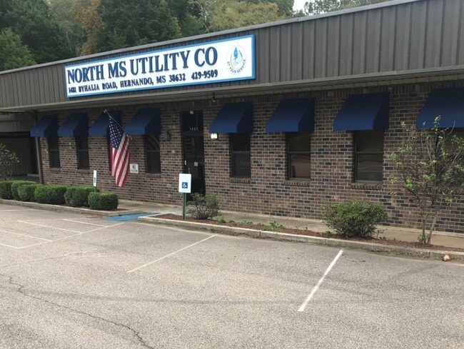
Property Record
1481 Byhalia Rd, Hernando, MS 38632

Property Detail
1481 Byhalia Rd
3073080000000101
8-3-7 PT N1/2 NE1/4
Officebuilding
Desoto
A
Mississippi
B and X Area of moderate flood hazard, usually the area between the limits of the 100-year and 500-year floods.
1
2025
4 AC
2025
DeSoto County
071001
Memphis
3,580 SF
Memphis, TN-MS-AR
NEARBY LISTINGS FOR SALE OR LEASE
DEMOGRAPHICS near 1481 Byhalia Rd
1 mile
3 mile
5 mile
2024 Total Population
2,699
19,224
37,175
2029 Population
2,806
20,140
39,133
Pop Growth 2024-2029
+ 3.96%
+ 4.76%
+ 5.27%
Average Age
41
39
39
2024 Total Households
1,017
6,899
12,960
HH Growth 2024-2029
+ 3.64%
+ 4.80%
+ 5.29%
Median Household Inc
$63,658
$82,252
$100,924
Avg Household Size
2.60
2.70
2.80
2024 Avg HH Vehicles
2.00
2.00
2.00
Median Home Value
$338,744
$336,165
$354,024
Median Year Built
2000
2000
2002
Nearby Places
Map Layers
Map Styles
 Street
 Aerial
Transit
 Traffic
 Biking
Places
Listings with unknown addresses are not visible on the map
- Restaurants
- Banks
- Shops
- Fitness
- Groceries
PUBLIC TRANSPORTATION
AIRPORT
Memphis International
Drive
Walk
Distance
Memphis International
27 min
18.2 mi
Freight Ports
Port of Shreveport
Drive
Walk
Distance
Port of Shreveport
429 min
391.9 mi
SALE & LEASE HISTORY
LISTING DATE
SALE/LEASE

Oct 20, 2020
For Sale
Nearby Properties
Address
Land Use
TOTAL SIZE
Lot Size
Zoning
Address
Land Use
TOTAL SIZE
Lot Size
Zoning
436,932 SF
153.19 AC
M-1
Address
Land Use
TOTAL SIZE
Lot Size
Zoning
19,367 SF
20.34 AC
PUD
Address
Land Use
TOTAL SIZE
Lot Size
Zoning
158,963 SF
20.07 AC
PUD
Address
Land Use
TOTAL SIZE
Lot Size
Zoning
120,095 SF
19.42 AC
C-2
Address
Land Use
TOTAL SIZE
Lot Size
Zoning
242,220 SF
27.54 AC
M-2
Address
Land Use
TOTAL SIZE
Lot Size
Zoning
64,797 SF
13.91 AC
M-1
Address
Land Use
TOTAL SIZE
Lot Size
Zoning
13,533 SF
1.50 AC
PUD
Address
Land Use
TOTAL SIZE
Lot Size
Zoning
71,484 SF
6.45 AC
C-2
Address
Land Use
TOTAL SIZE
Lot Size
Zoning
37,622 SF
5.63 AC
PUD
Address
Land Use
TOTAL SIZE
Lot Size
Zoning
12,002 SF
1.15 AC
M-1
Address
Land Use
TOTAL SIZE
Lot Size
Zoning
18,556 SF
5.50 AC
C-2
Address
Land Use
TOTAL SIZE
Lot Size
Zoning
45,515 SF
2.60 AC
C-2
Address
Land Use
TOTAL SIZE
Lot Size
Zoning
55,903 SF
5.70 AC
C-4
Address
Land Use
TOTAL SIZE
Lot Size
Zoning
3.12 AC
PUD
Address
Land Use
TOTAL SIZE
Lot Size
Zoning
54,098 SF
9.27 AC
M-1
Address
Land Use
TOTAL SIZE
Lot Size
Zoning
53,623 SF
2.69 AC
C-2
Address
Land Use
TOTAL SIZE
Lot Size
Zoning
15.10 AC
C-2
Address
Land Use
TOTAL SIZE
Lot Size
Zoning
24,163 SF
1.97 AC
C-2
Address
Land Use
TOTAL SIZE
Lot Size
Zoning
45,789 SF
10 AC
M-2
Address
Land Use
TOTAL SIZE
Lot Size
Zoning
12,201 SF
3.44 AC
M-1
Address
Land Use
TOTAL SIZE
Lot Size
Zoning
100,000 SF
9.90 AC
M-2
Address
Land Use
TOTAL SIZE
Lot Size
Zoning
23,530 SF
9.35 AC
M-1
Address
Land Use
TOTAL SIZE
Lot Size
Zoning
35,000 SF
4.72 AC
PUD
Address
Land Use
TOTAL SIZE
Lot Size
Zoning
46,498 SF
8.26 AC
M-1
Address
Land Use
TOTAL SIZE
Lot Size
Zoning
20,386 SF
3.24 AC
C-4
Address
Land Use
TOTAL SIZE
Lot Size
Zoning
37,074 SF
5.46 AC
C-2
Address
Land Use
TOTAL SIZE
Lot Size
Zoning
44,973 SF
4 AC
M-2
Address
Land Use
TOTAL SIZE
Lot Size
Zoning
40,831 SF
6.11 AC
C-2
Address
Land Use
TOTAL SIZE
Lot Size
Zoning
8,076 SF
4.04 AC
C-2
Address
Land Use
TOTAL SIZE
Lot Size
Zoning
21,206 SF
1.25 AC
C-4
The World's #1 Commercial Real Estate Marketplace
Connect with us
© 2026 CoStar Group
The information above has been obtained from sources believed reliable. While we do not doubt its accuracy we have not verified it and make no guarantee, warranty or representation about it. It is your responsibility to independently confirm its accuracy and completeness. Any projections, opinions, assumptions, or estimates used are for example only and do not represent the current or future performance of the property. The value of this transaction to you depends on tax and other factors which should be evaluated by your tax, financial, and legal advisors. You and your advisors should conduct a careful, independent investigation of the property to determine to your satisfaction the suitability of the property for your needs.