Property Record
14811 State Route 113, Wakeman, OH 44889

NEARBY LISTINGS FOR SALE OR LEASE
-
-
View all Wakeman listings for sale on LoopNet.com
Property Detail
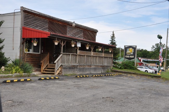
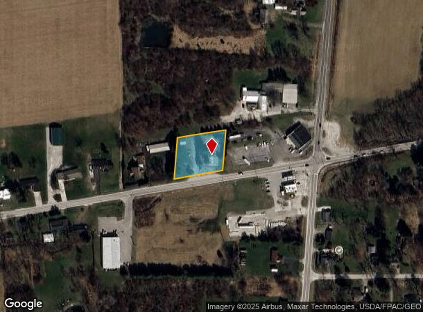
14811 State Route 113
07-00028-000
20-5-2 LOT 84 N PT N OF RD 1.00A
Restaurantbuilding
Erie
X
Ohio
39077C0150D
84
2024
1 AC
2024
Erie County
040300
Cleveland
2,783 SF
Sandusky, OH
DEMOGRAPHICS near 14811 State Route 113
1 mile
3 mile
5 mile
2024 Total Population
660
2,700
7,225
2029 Population
633
2,622
7,118
Pop Growth 2024-2029
(4.09%)
(2.89%)
(1.48%)
Average Age
47
47
46
2024 Total Households
273
1,110
2,958
HH Growth 2024-2029
(4.40%)
(3.15%)
(1.66%)
Median Household Inc
$79,032
$82,246
$79,907
Avg Household Size
2.40
2.40
2.40
2024 Avg HH Vehicles
2.00
3.00
3.00
Median Home Value
$224,264
$228,523
$235,065
Median Year Built
1972
1972
1973
Nearby Places
Map Layers
Map Styles
 Street
 Aerial
Transit
 Traffic
 Biking
Places
Listings with unknown addresses are not visible on the map
- Restaurants
- Banks
- Shops
- Fitness
- Groceries
PUBLIC TRANSPORTATION
AIRPORT
Cleveland-Hopkins International
Drive
Walk
Distance
Cleveland-Hopkins International
44 min
30.7 mi
Freight Ports
Port of Toledo
Drive
Walk
Distance
Port of Toledo
99 min
76.0 mi
SALE & LEASE HISTORY
LISTING DATE
SALE/LEASE

Aug 16, 2017
For Sale
Nearby Properties
Address
Land Use
TOTAL SIZE
Lot Size
Zoning
Address
Land Use
TOTAL SIZE
Lot Size
Zoning
47,997 SF
20.24 AC
Address
Land Use
TOTAL SIZE
Lot Size
Zoning
5,155 SF
131.49 AC
Address
Land Use
TOTAL SIZE
Lot Size
Zoning
53,525 SF
8.95 AC
Address
Land Use
TOTAL SIZE
Lot Size
Zoning
245.20 AC
Address
Land Use
TOTAL SIZE
Lot Size
Zoning
1,988 SF
189 AC
Address
Land Use
TOTAL SIZE
Lot Size
Zoning
20,000 SF
20.57 AC
Address
Land Use
TOTAL SIZE
Lot Size
Zoning
2,411 SF
135.01 AC
Address
Land Use
TOTAL SIZE
Lot Size
Zoning
7,918 SF
7.18 AC
Address
Land Use
TOTAL SIZE
Lot Size
Zoning
1,638 SF
154.98 AC
Address
Land Use
TOTAL SIZE
Lot Size
Zoning
9,080 SF
1.67 AC
Address
Land Use
TOTAL SIZE
Lot Size
Zoning
4,628 SF
74.09 AC
Address
Land Use
TOTAL SIZE
Lot Size
Zoning
11,490 SF
22.77 AC
Address
Land Use
TOTAL SIZE
Lot Size
Zoning
2,486 SF
106.27 AC
Address
Land Use
TOTAL SIZE
Lot Size
Zoning
1,901 SF
114 AC
Address
Land Use
TOTAL SIZE
Lot Size
Zoning
3,917 SF
99.87 AC
Address
Land Use
TOTAL SIZE
Lot Size
Zoning
1,120 SF
113.34 AC
Address
Land Use
TOTAL SIZE
Lot Size
Zoning
2,712 SF
104.39 AC
Address
Land Use
TOTAL SIZE
Lot Size
Zoning
1,644 SF
118.58 AC
Address
Land Use
TOTAL SIZE
Lot Size
Zoning
910 SF
35.53 AC
Address
Land Use
TOTAL SIZE
Lot Size
Zoning
1,088 SF
40.78 AC
Address
Land Use
TOTAL SIZE
Lot Size
Zoning
4,692 SF
39.04 AC
Address
Land Use
TOTAL SIZE
Lot Size
Zoning
2,562 SF
95.78 AC
Address
Land Use
TOTAL SIZE
Lot Size
Zoning
42,351 SF
2.43 AC
Address
Land Use
TOTAL SIZE
Lot Size
Zoning
2,458 SF
84 AC
Address
Land Use
TOTAL SIZE
Lot Size
Zoning
92.32 AC
Address
Land Use
TOTAL SIZE
Lot Size
Zoning
3,061 SF
74.82 AC
Address
Land Use
TOTAL SIZE
Lot Size
Zoning
5,421 SF
34.62 AC
Address
Land Use
TOTAL SIZE
Lot Size
Zoning
98.18 AC
Address
Land Use
TOTAL SIZE
Lot Size
Zoning
888 SF
91.79 AC
Address
Land Use
TOTAL SIZE
Lot Size
Zoning
89.76 AC
The World's #1 Commercial Real Estate Marketplace
Connect with us
© 2026 CoStar Group
The information above has been obtained from sources believed reliable. While we do not doubt its accuracy we have not verified it and make no guarantee, warranty or representation about it. It is your responsibility to independently confirm its accuracy and completeness. Any projections, opinions, assumptions, or estimates used are for example only and do not represent the current or future performance of the property. The value of this transaction to you depends on tax and other factors which should be evaluated by your tax, financial, and legal advisors. You and your advisors should conduct a careful, independent investigation of the property to determine to your satisfaction the suitability of the property for your needs.