Property Record
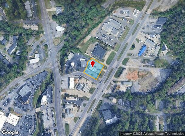
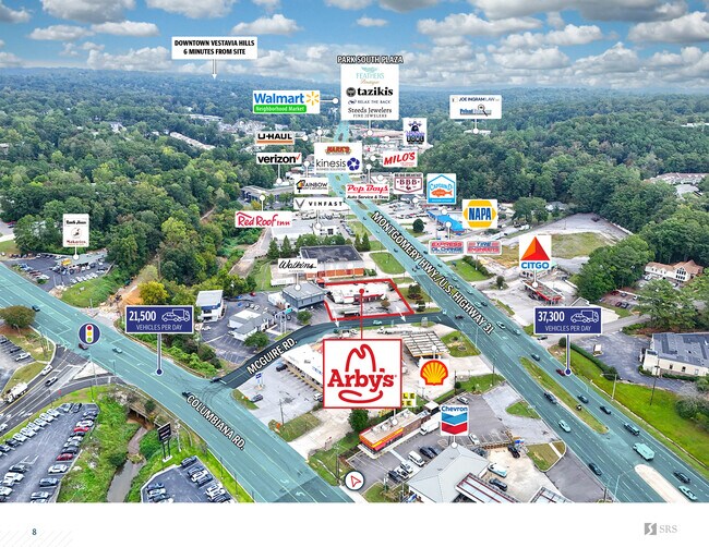
1482 Montgomery Hwy, Vestavia Hills, AL 35216
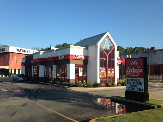
This Property Is For Sale
NEARBY LISTINGS FOR SALE OR LEASE
Property Detail
1482 Montgomery Hwy
Birmingham-Hoover, AL
Resur Of Mcguires Add
39-00-01-2-000-045.000
LOT 1-C & PT OF LOT 1-D RESUR OF MCGUIRES ADD TO VESTAVIA 117/86 & TRACT ALL BEING DESC AS FOLS BEG MOST SLY COR LOT 1-C TH NW 156 TH NE 77 FT TH NELY 56.6 FT TH NE 36.4 FT TH NELY 17 FT TH SE 156 FT TH SW 175.4 FT TO POB SECT 01 TWSP 19S RANGE 3W
Restaurantbuilding
Jefferson
AE
Alabama
01073C0566J
1-c
2023
0.68 AC
2024
Vestavia Hills
012920
Birmingham
3,211 SF
DEMOGRAPHICS near 1482 Montgomery Hwy
1 Mile
3 Mile
5 Mile
2024 Total Population
9,407
62,371
143,583
2029 Population
9,216
60,278
141,582
Pop Growth 2024-2029
(2.03%)
(3.36%)
(1.39%)
Average Age
39
38
38
2024 Total Households
4,071
26,081
60,349
HH Growth 2024-2029
(2.14%)
(3.49%)
(1.52%)
Median Household Inc
$66,537
$81,195
$79,307
Avg Household Size
2.20
2.30
2.30
2024 Avg HH Vehicles
2.00
2.00
2.00
Median Home Value
$324,606
$338,606
$359,109
Median Year Built
1973
1978
1982
Nearby Places
- Restaurants
- Banks
- Shops
- Fitness
- Groceries
PUBLIC TRANSPORTATION
COMMUTER RAIL
Birmingham (Crescent - Amtrak)
DRIVE
WALK
Distance
Birmingham (Crescent - Amtrak)
12 min
9.1 mi
AIRPORT
Birmingham-Shuttlesworth International
DRIVE
WALK
Distance
Birmingham-Shuttlesworth International
21 min
12.8 mi
Freight Ports
Port of Mobile
DRIVE
WALK
Distance
Port of Mobile
270 min
248.1 mi
Nearby Properties
Address
Land Use
TOTAL SIZE
Lot Size
Zoning
Address
Land Use
TOTAL SIZE
Lot Size
Zoning
515,818 SF
38 AC
CP
Address
Land Use
TOTAL SIZE
Lot Size
Zoning
1,008,008 SF
73.91 AC
R4
Address
Land Use
TOTAL SIZE
Lot Size
Zoning
745,655 SF
16 AC
C-1
Address
Land Use
TOTAL SIZE
Lot Size
Zoning
Address
Land Use
TOTAL SIZE
Lot Size
Zoning
334,805 SF
32.50 AC
MXD/
Address
Land Use
TOTAL SIZE
Lot Size
Zoning
200,927 SF
19 AC
PMUD
Address
Land Use
TOTAL SIZE
Lot Size
Zoning
80,269 SF
2.50 AC
C-1
Address
Land Use
TOTAL SIZE
Lot Size
Zoning
186,070 SF
16.60 AC
QB2
Address
Land Use
TOTAL SIZE
Lot Size
Zoning
365,402 SF
25 AC
R4
Address
Land Use
TOTAL SIZE
Lot Size
Zoning
92,332 SF
8.40 AC
Address
Land Use
TOTAL SIZE
Lot Size
Zoning
265,418 SF
26.55 AC
R2
Address
Land Use
TOTAL SIZE
Lot Size
Zoning
133,396 SF
19 AC
QR6
Address
Land Use
TOTAL SIZE
Lot Size
Zoning
294,855 SF
30 AC
R4
Address
Land Use
TOTAL SIZE
Lot Size
Zoning
41,980 SF
26.70 AC
PC
Address
Land Use
TOTAL SIZE
Lot Size
Zoning
94,094 SF
14.40 AC
PO-P
Address
Land Use
TOTAL SIZE
Lot Size
Zoning
446,170 SF
18.93 AC
PR2
Address
Land Use
TOTAL SIZE
Lot Size
Zoning
160,443 SF
23 AC
C-2
Address
Land Use
TOTAL SIZE
Lot Size
Zoning
170,850 SF
9.31 AC
INST
Address
Land Use
TOTAL SIZE
Lot Size
Zoning
285,719 SF
18 AC
R-4
Address
Land Use
TOTAL SIZE
Lot Size
Zoning
176,949 SF
19 AC
PC
Address
Land Use
TOTAL SIZE
Lot Size
Zoning
313,404 SF
19 AC
PMUD
Address
Land Use
TOTAL SIZE
Lot Size
Zoning
218,354 SF
15.23 AC
R4
Address
Land Use
TOTAL SIZE
Lot Size
Zoning
195,150 SF
11 AC
R-5
Address
Land Use
TOTAL SIZE
Lot Size
Zoning
191,623 SF
19.93 AC
R4
Address
Land Use
TOTAL SIZE
Lot Size
Zoning
295,144 SF
22 AC
PR-2
Address
Land Use
TOTAL SIZE
Lot Size
Zoning
76,816 SF
4.90 AC
PO
Address
Land Use
TOTAL SIZE
Lot Size
Zoning
517,500 SF
29 AC
I1
Address
Land Use
TOTAL SIZE
Lot Size
Zoning
221,936 SF
14.18 AC
R4
Address
Land Use
TOTAL SIZE
Lot Size
Zoning
189,182 SF
23.40 AC
PMUD
Address
Land Use
TOTAL SIZE
Lot Size
Zoning
246,696 SF
13.89 AC
R4
The World's #1 Commercial Real Estate Marketplace
Connect with us
© 2025 CoStar Group
The information above has been obtained from sources believed reliable. While we do not doubt its accuracy we have not verified it and make no guarantee, warranty or representation about it. It is your responsibility to independently confirm its accuracy and completeness. Any projections, opinions, assumptions, or estimates used are for example only and do not represent the current or future performance of the property. The value of this transaction to you depends on tax and other factors which should be evaluated by your tax, financial, and legal advisors. You and your advisors should conduct a careful, independent investigation of the property to determine to your satisfaction the suitability of the property for your needs.