Property Record
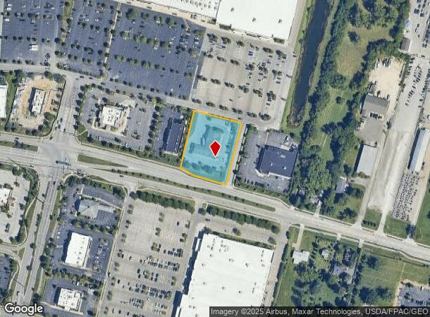
1482 Stringtown Rd, Grove City, OH 43123

NEARBY LISTINGS FOR SALE OR LEASE
Property Detail
1482 Stringtown Rd
040-013871
Virginia Military District Sur
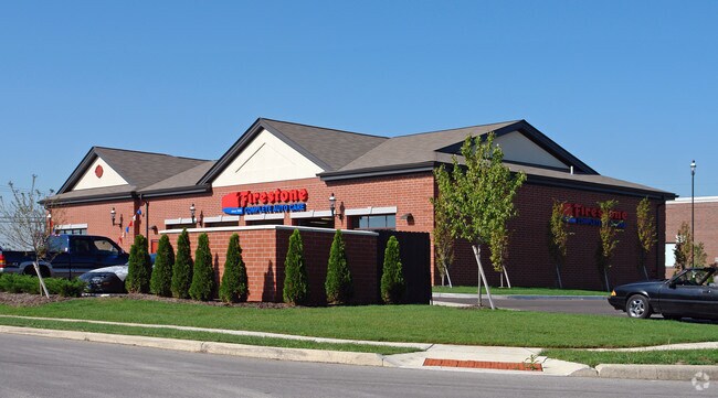
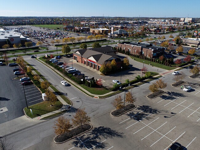
Autorepair
1482 STRINGTOWN RD ENTRY 469-8231 1.282 ACRES
X
Franklin
39049C0318K
Ohio
2024
1.28 AC
2025
Southwest
009755
Columbus
7,842 SF
Columbus, OH
DEMOGRAPHICS near 1482 Stringtown Rd
1 mile
3 mile
5 mile
2024 Total Population
3,106
51,003
144,504
2029 Population
3,099
51,139
144,983
Pop Growth 2024-2029
(0.23%)
+ 0.27%
+ 0.33%
Average Age
43
40
39
2024 Total Households
1,368
19,718
55,822
HH Growth 2024-2029
(0.37%)
+ 0.21%
+ 0.31%
Median Household Inc
$101,439
$76,104
$66,759
Avg Household Size
2.20
2.50
2.50
2024 Avg HH Vehicles
2.00
2.00
2.00
Median Home Value
$400,350
$223,742
$190,064
Median Year Built
2006
1990
1974
Nearby Places
Map Layers
Map Styles
 Street
 Aerial
Transit
 Traffic
 Biking
Places
Listings with unknown addresses are not visible on the map
- Restaurants
- Banks
- Shops
- Fitness
- Groceries
PUBLIC TRANSPORTATION
AIRPORT
Rickenbacker International
Drive
Walk
Distance
Rickenbacker International
19 min
11.5 mi
John Glenn Columbus International
Drive
Walk
Distance
John Glenn Columbus International
24 min
15.2 mi
SALE & LEASE HISTORY
LISTING DATE
SALE/LEASE

Nov 04, 2020
For Sale
Nearby Properties
Address
Land Use
TOTAL SIZE
Lot Size
Zoning
Address
Land Use
TOTAL SIZE
Lot Size
Zoning
844,679 SF
61.71 AC
Address
Land Use
TOTAL SIZE
Lot Size
Zoning
382.42 AC
Address
Land Use
TOTAL SIZE
Lot Size
Zoning
1,172,656 SF
480.43 AC
Address
Land Use
TOTAL SIZE
Lot Size
Zoning
1,058 SF
0.03 AC
Address
Land Use
TOTAL SIZE
Lot Size
Zoning
125,467 SF
20.61 AC
Address
Land Use
TOTAL SIZE
Lot Size
Zoning
928,228 SF
39.80 AC
Address
Land Use
TOTAL SIZE
Lot Size
Zoning
128,263 SF
6.59 AC
Address
Land Use
TOTAL SIZE
Lot Size
Zoning
169,252 SF
22.06 AC
Address
Land Use
TOTAL SIZE
Lot Size
Zoning
227,844 SF
21.57 AC
Address
Land Use
TOTAL SIZE
Lot Size
Zoning
322,000 SF
22.14 AC
Address
Land Use
TOTAL SIZE
Lot Size
Zoning
408,294 SF
26.64 AC
Address
Land Use
TOTAL SIZE
Lot Size
Zoning
322,000 SF
18.83 AC
Address
Land Use
TOTAL SIZE
Lot Size
Zoning
407,124 SF
41.33 AC
Address
Land Use
TOTAL SIZE
Lot Size
Zoning
227,576 SF
52.33 AC
Address
Land Use
TOTAL SIZE
Lot Size
Zoning
111,874 SF
21.97 AC
Address
Land Use
TOTAL SIZE
Lot Size
Zoning
118,968 SF
13.09 AC
Address
Land Use
TOTAL SIZE
Lot Size
Zoning
60,893 SF
19.92 AC
Address
Land Use
TOTAL SIZE
Lot Size
Zoning
137,488 SF
13.44 AC
Address
Land Use
TOTAL SIZE
Lot Size
Zoning
132,379 SF
15.46 AC
Address
Land Use
TOTAL SIZE
Lot Size
Zoning
61,595 SF
9.75 AC
Address
Land Use
TOTAL SIZE
Lot Size
Zoning
146,172 SF
26.42 AC
Address
Land Use
TOTAL SIZE
Lot Size
Zoning
36,877 SF
21.13 AC
Address
Land Use
TOTAL SIZE
Lot Size
Zoning
221,616 SF
10.62 AC
Address
Land Use
TOTAL SIZE
Lot Size
Zoning
81,687 SF
10.19 AC
Address
Land Use
TOTAL SIZE
Lot Size
Zoning
110,447 SF
28.14 AC
Address
Land Use
TOTAL SIZE
Lot Size
Zoning
75,164 SF
16.26 AC
Address
Land Use
TOTAL SIZE
Lot Size
Zoning
110,694 SF
2.64 AC
Address
Land Use
TOTAL SIZE
Lot Size
Zoning
73,908 SF
9 AC
Address
Land Use
TOTAL SIZE
Lot Size
Zoning
139,123 SF
24.67 AC
Address
Land Use
TOTAL SIZE
Lot Size
Zoning
53,568 SF
1.14 AC
The World's #1 Commercial Real Estate Marketplace
Connect with us
© 2026 CoStar Group
The information above has been obtained from sources believed reliable. While we do not doubt its accuracy we have not verified it and make no guarantee, warranty or representation about it. It is your responsibility to independently confirm its accuracy and completeness. Any projections, opinions, assumptions, or estimates used are for example only and do not represent the current or future performance of the property. The value of this transaction to you depends on tax and other factors which should be evaluated by your tax, financial, and legal advisors. You and your advisors should conduct a careful, independent investigation of the property to determine to your satisfaction the suitability of the property for your needs.