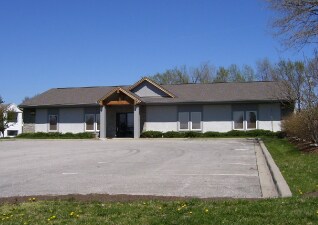
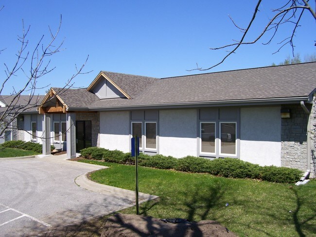
Property Record
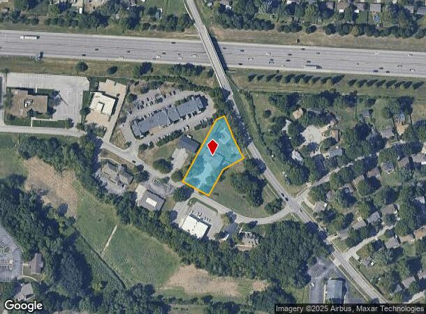
14820 E 42Nd St S, Independence, MO 64055

NEARBY LISTINGS FOR SALE OR LEASE
Property Detail
14820 E 42Nd St S
33-130-18-08-00-0-00-000
Mei Tract I & Ii
Officebuilding
MEI TRACT I & II TRACT-II
X
Jackson
29095C0292G
Missouri
0
0.96 AC
2025
East Jackson County
014501
Kansas City
3,200 SF
Kansas City, MO-KS
DEMOGRAPHICS near 14820 E 42Nd St S
1 Mile
3 Mile
5 Mile
2024 Total Population
8,920
67,444
152,409
2029 Population
8,716
66,512
151,129
Pop Growth 2024-2029
(2.29%)
(1.38%)
(0.84%)
Average Age
43
42
42
2024 Total Households
3,877
28,625
63,230
HH Growth 2024-2029
(2.42%)
(1.54%)
(0.97%)
Median Household Inc
$66,909
$63,166
$61,387
Avg Household Size
2.20
2.30
2.30
2024 Avg HH Vehicles
2.00
2.00
2.00
Median Home Value
$169,041
$169,804
$168,867
Median Year Built
1968
1971
1969
Nearby Places
Map Layers
Map Styles
 Street
 Aerial
- Restaurants
- Banks
- Shops
- Fitness
- Groceries
PUBLIC TRANSPORTATION
COMMUTER RAIL
DRIVE
WALK
Distance
10 min
4.8 mi
AIRPORT
Kansas City International
DRIVE
WALK
Distance
Kansas City International
43 min
31.2 mi
Nearby Properties
Address
Land Use
TOTAL SIZE
Lot Size
Zoning
Address
Land Use
TOTAL SIZE
Lot Size
Zoning
519,315 SF
28.47 AC
Address
Land Use
TOTAL SIZE
Lot Size
Zoning
158,369 SF
47.47 AC
Address
Land Use
TOTAL SIZE
Lot Size
Zoning
100,724 SF
1.65 AC
Address
Land Use
TOTAL SIZE
Lot Size
Zoning
455,100 SF
42.02 AC
Address
Land Use
TOTAL SIZE
Lot Size
Zoning
385,487 SF
5.61 AC
Address
Land Use
TOTAL SIZE
Lot Size
Zoning
338,731 SF
29.59 AC
Address
Land Use
TOTAL SIZE
Lot Size
Zoning
171,513 SF
18.37 AC
Address
Land Use
TOTAL SIZE
Lot Size
Zoning
64,318 SF
32.40 AC
Address
Land Use
TOTAL SIZE
Lot Size
Zoning
96,348 SF
14.42 AC
Address
Land Use
TOTAL SIZE
Lot Size
Zoning
94,411 SF
4.99 AC
Address
Land Use
TOTAL SIZE
Lot Size
Zoning
61,901 SF
15.11 AC
Address
Land Use
TOTAL SIZE
Lot Size
Zoning
210,008 SF
16.89 AC
Address
Land Use
TOTAL SIZE
Lot Size
Zoning
67,820 SF
11.94 AC
Address
Land Use
TOTAL SIZE
Lot Size
Zoning
20.97 AC
Address
Land Use
TOTAL SIZE
Lot Size
Zoning
178,652 SF
15.07 AC
Address
Land Use
TOTAL SIZE
Lot Size
Zoning
113,696 SF
28.25 AC
Address
Land Use
TOTAL SIZE
Lot Size
Zoning
68,921 SF
18.04 AC
Address
Land Use
TOTAL SIZE
Lot Size
Zoning
148,044 SF
17.85 AC
Address
Land Use
TOTAL SIZE
Lot Size
Zoning
137,992 SF
12.50 AC
Address
Land Use
TOTAL SIZE
Lot Size
Zoning
Address
Land Use
TOTAL SIZE
Lot Size
Zoning
42,188 SF
7.82 AC
Address
Land Use
TOTAL SIZE
Lot Size
Zoning
147,000 SF
Address
Land Use
TOTAL SIZE
Lot Size
Zoning
48,664 SF
8.44 AC
Address
Land Use
TOTAL SIZE
Lot Size
Zoning
190,810 SF
26.90 AC
Address
Land Use
TOTAL SIZE
Lot Size
Zoning
23,925 SF
19.96 AC
Address
Land Use
TOTAL SIZE
Lot Size
Zoning
135,346 SF
14.64 AC
Address
Land Use
TOTAL SIZE
Lot Size
Zoning
45,832 SF
8.61 AC
Address
Land Use
TOTAL SIZE
Lot Size
Zoning
103,866 SF
13.29 AC
Address
Land Use
TOTAL SIZE
Lot Size
Zoning
66,168 SF
44.98 AC
Address
Land Use
TOTAL SIZE
Lot Size
Zoning
60,050 SF
5.34 AC
The World's #1 Commercial Real Estate Marketplace
Connect with us
© 2025 CoStar Group
The information above has been obtained from sources believed reliable. While we do not doubt its accuracy we have not verified it and make no guarantee, warranty or representation about it. It is your responsibility to independently confirm its accuracy and completeness. Any projections, opinions, assumptions, or estimates used are for example only and do not represent the current or future performance of the property. The value of this transaction to you depends on tax and other factors which should be evaluated by your tax, financial, and legal advisors. You and your advisors should conduct a careful, independent investigation of the property to determine to your satisfaction the suitability of the property for your needs.