Property Record
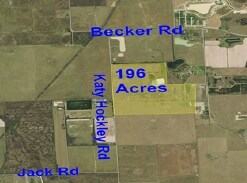
14820 Katy Hockley Rd, Hockley, TX 77447
NEARBY LISTINGS FOR SALE OR LEASE
Property Detail
14820 Katy Hockley Rd
Houston-The Woodlands-Sugar Land, TX
Abst 90 J Askins
0410460000017
TR 2 ABST 90 J ASKINS
Agriculturalland
Harris
X
Texas
48201C0385N
157.38 AC
2024
Northwest Outlier
2025
Houston
680601
DEMOGRAPHICS near 14820 Katy Hockley Rd
1 Mile
3 Mile
5 Mile
2024 Total Population
60
8,976
45,668
2029 Population
62
9,204
46,918
Pop Growth 2024-2029
+ 3.33%
+ 2.54%
+ 2.74%
Average Age
32
33
35
2024 Total Households
18
2,696
13,964
HH Growth 2024-2029
+ 5.56%
+ 2.45%
+ 2.74%
Median Household Inc
$116,666
$99,197
$116,194
Avg Household Size
3.10
3.30
3.30
2024 Avg HH Vehicles
2.00
2.00
2.00
Median Home Value
$344,444
$282,852
$318,187
Median Year Built
2011
2009
2010
Nearby Places
Map Layers
Map Styles
 Street
 Aerial
- Restaurants
- Banks
- Shops
- Fitness
- Groceries
PUBLIC TRANSPORTATION
AIRPORT
George Bush Intcntl/Houston
DRIVE
WALK
Distance
George Bush Intcntl/Houston
54 min
35.9 mi
Freight Ports
Port of Houston
DRIVE
WALK
Distance
Port of Houston
64 min
44.6 mi
Nearby Properties
Address
Land Use
TOTAL SIZE
Lot Size
Zoning
Address
Land Use
TOTAL SIZE
Lot Size
Zoning
1,207.31 AC
Address
Land Use
TOTAL SIZE
Lot Size
Zoning
785.28 AC
Address
Land Use
TOTAL SIZE
Lot Size
Zoning
61,242 SF
30 AC
Address
Land Use
TOTAL SIZE
Lot Size
Zoning
134.10 AC
Address
Land Use
TOTAL SIZE
Lot Size
Zoning
108.28 AC
Address
Land Use
TOTAL SIZE
Lot Size
Zoning
698.98 AC
Address
Land Use
TOTAL SIZE
Lot Size
Zoning
520.66 AC
Address
Land Use
TOTAL SIZE
Lot Size
Zoning
568.93 AC
Address
Land Use
TOTAL SIZE
Lot Size
Zoning
34,298 SF
28.42 AC
Address
Land Use
TOTAL SIZE
Lot Size
Zoning
191,008 SF
20.47 AC
Address
Land Use
TOTAL SIZE
Lot Size
Zoning
60,800 SF
1.93 AC
Address
Land Use
TOTAL SIZE
Lot Size
Zoning
298.56 AC
Address
Land Use
TOTAL SIZE
Lot Size
Zoning
156.25 AC
Address
Land Use
TOTAL SIZE
Lot Size
Zoning
245.22 AC
Address
Land Use
TOTAL SIZE
Lot Size
Zoning
383.95 AC
Address
Land Use
TOTAL SIZE
Lot Size
Zoning
65.15 AC
Address
Land Use
TOTAL SIZE
Lot Size
Zoning
1,050 SF
714.14 AC
Address
Land Use
TOTAL SIZE
Lot Size
Zoning
Address
Land Use
TOTAL SIZE
Lot Size
Zoning
149.01 AC
Address
Land Use
TOTAL SIZE
Lot Size
Zoning
557.31 AC
Address
Land Use
TOTAL SIZE
Lot Size
Zoning
60,390 SF
13.71 AC
Address
Land Use
TOTAL SIZE
Lot Size
Zoning
628.42 AC
Address
Land Use
TOTAL SIZE
Lot Size
Zoning
73.73 AC
Address
Land Use
TOTAL SIZE
Lot Size
Zoning
22.72 AC
Address
Land Use
TOTAL SIZE
Lot Size
Zoning
207.98 AC
Address
Land Use
TOTAL SIZE
Lot Size
Zoning
284.51 AC
Address
Land Use
TOTAL SIZE
Lot Size
Zoning
96.10 AC
Address
Land Use
TOTAL SIZE
Lot Size
Zoning
240.01 AC
Address
Land Use
TOTAL SIZE
Lot Size
Zoning
101.74 AC
Address
Land Use
TOTAL SIZE
Lot Size
Zoning
11,108 SF
4.02 AC
The World's #1 Commercial Real Estate Marketplace
Connect with us
© 2025 CoStar Group
The information above has been obtained from sources believed reliable. While we do not doubt its accuracy we have not verified it and make no guarantee, warranty or representation about it. It is your responsibility to independently confirm its accuracy and completeness. Any projections, opinions, assumptions, or estimates used are for example only and do not represent the current or future performance of the property. The value of this transaction to you depends on tax and other factors which should be evaluated by your tax, financial, and legal advisors. You and your advisors should conduct a careful, independent investigation of the property to determine to your satisfaction the suitability of the property for your needs.