Property Record
14827 Interstate 10 E, Baytown, TX 77523
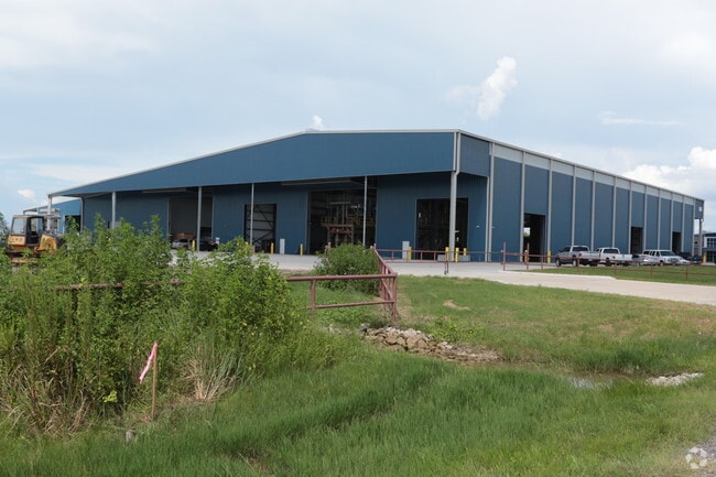
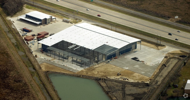
Property Detail
14827 Interstate 10 E
00210-07300-00100-100001
210 73-1-2 F C RECTOR
Industrialgeneral
Chambers
B and X Area of moderate flood hazard, usually the area between the limits of the 100-year and 500-year floods.
Texas
2025
20.87 AC
2025
East-Southeast Far
710100
Houston
6,500 SF
Houston-Pasadena-The Woodlands, TX
NEARBY LISTINGS FOR SALE OR LEASE
DEMOGRAPHICS near 14827 Interstate 10 E
1 mile
3 mile
5 mile
2025 Total Population
5,374
20,297
37,423
2030 Population
6,451
24,255
44,633
Pop Growth 2025-2030
+ 20.04%
+ 19.50%
+ 19.27%
Average Age
35
35
36
2025 Total Households
1,732
6,505
12,072
HH Growth 2025-2030
+ 20.27%
+ 19.68%
+ 19.38%
Median Household Inc
$115,445
$119,980
$117,353
Avg Household Size
3.10
3.10
3.10
2025 Avg HH Vehicles
2.00
2.00
2.00
Median Home Value
$368,722
$371,798
$343,040
Median Year Built
2010
2010
2010
Nearby Places
Map Layers
Map Styles
 Street
 Aerial
Layers
 Traffic
 Biking
Places
Listings with unknown addresses are not visible on the map
- Restaurants
- Banks
- Shops
- Fitness
- Groceries
PUBLIC TRANSPORTATION
AIRPORT
William P Hobby
Drive
Walk
Distance
William P Hobby
55 min
38.9 mi
Freight Ports
Port of Houston
Drive
Walk
Distance
Port of Houston
42 min
30.9 mi
Nearby Properties
Address
Land Use
TOTAL SIZE
Lot Size
Zoning
Address
Land Use
TOTAL SIZE
Lot Size
Zoning
194,400 SF
53.79 AC
Address
Land Use
TOTAL SIZE
Lot Size
Zoning
11,189 SF
7.40 AC
Address
Land Use
TOTAL SIZE
Lot Size
Zoning
3,900 SF
42.94 AC
Address
Land Use
TOTAL SIZE
Lot Size
Zoning
13,927 SF
23.39 AC
Address
Land Use
TOTAL SIZE
Lot Size
Zoning
9,087 SF
6.98 AC
Address
Land Use
TOTAL SIZE
Lot Size
Zoning
222,375 SF
42.92 AC
Address
Land Use
TOTAL SIZE
Lot Size
Zoning
34,504 SF
9.19 AC
Address
Land Use
TOTAL SIZE
Lot Size
Zoning
2,239 SF
9.15 AC
Address
Land Use
TOTAL SIZE
Lot Size
Zoning
86,209 SF
13.40 AC
Address
Land Use
TOTAL SIZE
Lot Size
Zoning
27,008 SF
20.38 AC
Address
Land Use
TOTAL SIZE
Lot Size
Zoning
8,384 SF
10.23 AC
Address
Land Use
TOTAL SIZE
Lot Size
Zoning
54,878 SF
8.65 AC
Address
Land Use
TOTAL SIZE
Lot Size
Zoning
2,190 SF
29.10 AC
Address
Land Use
TOTAL SIZE
Lot Size
Zoning
432 SF
19.63 AC
Address
Land Use
TOTAL SIZE
Lot Size
Zoning
9,767 SF
5 AC
Address
Land Use
TOTAL SIZE
Lot Size
Zoning
13.29 AC
Address
Land Use
TOTAL SIZE
Lot Size
Zoning
14,245 SF
3 AC
Address
Land Use
TOTAL SIZE
Lot Size
Zoning
1,645 SF
32.38 AC
Address
Land Use
TOTAL SIZE
Lot Size
Zoning
24.26 AC
Address
Land Use
TOTAL SIZE
Lot Size
Zoning
6,609 SF
5.07 AC
Address
Land Use
TOTAL SIZE
Lot Size
Zoning
9,522 SF
9 AC
Address
Land Use
TOTAL SIZE
Lot Size
Zoning
8,060 SF
3.73 AC
Address
Land Use
TOTAL SIZE
Lot Size
Zoning
4,021 SF
72.79 AC
Address
Land Use
TOTAL SIZE
Lot Size
Zoning
28,608 SF
7.39 AC
Address
Land Use
TOTAL SIZE
Lot Size
Zoning
9,200 SF
32.76 AC
Address
Land Use
TOTAL SIZE
Lot Size
Zoning
1,978 SF
9.01 AC
Address
Land Use
TOTAL SIZE
Lot Size
Zoning
38.96 AC
Address
Land Use
TOTAL SIZE
Lot Size
Zoning
24.22 AC
Address
Land Use
TOTAL SIZE
Lot Size
Zoning
8,891 SF
3 AC
The World's #1 Commercial Real Estate Marketplace
Connect with us
© 2026 CoStar Group
The information above has been obtained from sources believed reliable. While we do not doubt its accuracy we have not verified it and make no guarantee, warranty or representation about it. It is your responsibility to independently confirm its accuracy and completeness. Any projections, opinions, assumptions, or estimates used are for example only and do not represent the current or future performance of the property. The value of this transaction to you depends on tax and other factors which should be evaluated by your tax, financial, and legal advisors. You and your advisors should conduct a careful, independent investigation of the property to determine to your satisfaction the suitability of the property for your needs.