No Photo
Property Record
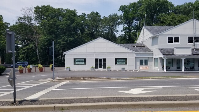
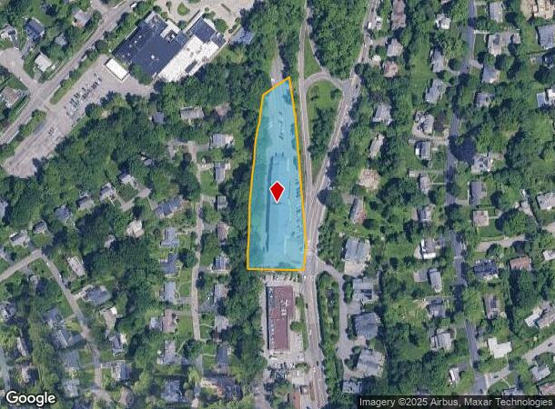
1483 Weaver St, Scarsdale, NY 10583
NEARBY LISTINGS FOR SALE OR LEASE
Property Detail
1483 Weaver St
1000-000-008-03300-000-0125
Westchester
Stripcommercialcenter
New York
AE
0.125
36119C0332F
2.30 AC
2025
Southeast
2024
Westchester/So Connecticut
006801
New York-Jersey City-White Plains, NY-NJ
DEMOGRAPHICS near 1483 Weaver St
1 Mile
3 Mile
5 Mile
2024 Total Population
10,628
111,397
346,776
2029 Population
10,446
109,207
340,791
Pop Growth 2024-2029
(1.71%)
(1.97%)
(1.73%)
Average Age
41
42
42
2024 Total Households
3,334
39,817
128,609
HH Growth 2024-2029
(1.86%)
(2.06%)
(1.76%)
Median Household Inc
$244,905
$169,054
$136,529
Avg Household Size
3.10
2.70
2.60
2024 Avg HH Vehicles
2.00
2.00
2.00
Median Home Value
$1,018,288
$803,273
$719,830
Median Year Built
1954
1954
1955
Nearby Places
- Restaurants
- Banks
- Shops
- Fitness
- Groceries
PUBLIC TRANSPORTATION
COMMUTER RAIL
Scarsdale Station (Harlem Line - Metro-North Commuter Railroad Company (Metro-North))
DRIVE
WALK
Distance
Scarsdale Station (Harlem Line - Metro-North Commuter Railroad Company (Metro-North))
10 min
2.6 mi
Hartsdale Station (Harlem Line - Metro-North Commuter Railroad Company (Metro-North))
DRIVE
WALK
Distance
Hartsdale Station (Harlem Line - Metro-North Commuter Railroad Company (Metro-North))
10 min
2.9 mi
AIRPORT
Westchester County
DRIVE
WALK
Distance
Westchester County
17 min
11.8 mi
LaGuardia
DRIVE
WALK
Distance
LaGuardia
28 min
20.0 mi
John F Kennedy International
DRIVE
WALK
Distance
John F Kennedy International
36 min
27.3 mi
Freight Ports
NY - Red Hook Container Terminal
DRIVE
WALK
Distance
NY - Red Hook Container Terminal
1 min
23.7 mi
SALE & LEASE HISTORY
LISTING DATE
SALE/LEASE

Sep 25, 2016
For Lease
May 23, 2017
For Lease
Jun 15, 2017
For Lease
Jul 11, 2019
For Lease
Feb 19, 2020
For Lease
Nearby Properties
Address
Land Use
TOTAL SIZE
Lot Size
Zoning
Address
Land Use
TOTAL SIZE
Lot Size
Zoning
Address
Land Use
TOTAL SIZE
Lot Size
Zoning
381,836 SF
16.68 AC
A3
Address
Land Use
TOTAL SIZE
Lot Size
Zoning
Address
Land Use
TOTAL SIZE
Lot Size
Zoning
66 AC
R-20
Address
Land Use
TOTAL SIZE
Lot Size
Zoning
237,313 SF
22.67 AC
A1
Address
Land Use
TOTAL SIZE
Lot Size
Zoning
13.22 AC
CA
Address
Land Use
TOTAL SIZE
Lot Size
Zoning
77.52 AC
A3
Address
Land Use
TOTAL SIZE
Lot Size
Zoning
125,010 SF
4.02 AC
Address
Land Use
TOTAL SIZE
Lot Size
Zoning
21.33 AC
Address
Land Use
TOTAL SIZE
Lot Size
Zoning
82,895 SF
23.03 AC
A2
Address
Land Use
TOTAL SIZE
Lot Size
Zoning
188.31 AC
Address
Land Use
TOTAL SIZE
Lot Size
Zoning
67.51 AC
Address
Land Use
TOTAL SIZE
Lot Size
Zoning
5COMMUND
Address
Land Use
TOTAL SIZE
Lot Size
Zoning
5.57 AC
AA1
Address
Land Use
TOTAL SIZE
Lot Size
Zoning
48,499 SF
8.52 AC
A2/A3
Address
Land Use
TOTAL SIZE
Lot Size
Zoning
61,606 SF
19.99 AC
A4/A3
Address
Land Use
TOTAL SIZE
Lot Size
Zoning
98,910 SF
0.91 AC
VCR-0
Address
Land Use
TOTAL SIZE
Lot Size
Zoning
48,267 SF
11.04 AC
A2 A
Address
Land Use
TOTAL SIZE
Lot Size
Zoning
6.31 AC
R-5 SFR
Address
Land Use
TOTAL SIZE
Lot Size
Zoning
37,187 SF
2.62 AC
Address
Land Use
TOTAL SIZE
Lot Size
Zoning
11.21 AC
R-20
Address
Land Use
TOTAL SIZE
Lot Size
Zoning
67,917 SF
6.79 AC
A4
Address
Land Use
TOTAL SIZE
Lot Size
Zoning
1,451 SF
6.97 AC
CA
Address
Land Use
TOTAL SIZE
Lot Size
Zoning
34,454 SF
216.47 AC
Address
Land Use
TOTAL SIZE
Lot Size
Zoning
68,022 SF
4.31 AC
Address
Land Use
TOTAL SIZE
Lot Size
Zoning
58,450 SF
0.38 AC
VCR-2
Address
Land Use
TOTAL SIZE
Lot Size
Zoning
2,100 SF
24.12 AC
A3
Address
Land Use
TOTAL SIZE
Lot Size
Zoning
26,138 SF
0.33 AC
PUD-1
Address
Land Use
TOTAL SIZE
Lot Size
Zoning
2.26 AC
CA
Address
Land Use
TOTAL SIZE
Lot Size
Zoning
76,258 SF
4.22 AC
R7.5
The World's #1 Commercial Real Estate Marketplace
Connect with us
© 2025 CoStar Group
The information above has been obtained from sources believed reliable. While we do not doubt its accuracy we have not verified it and make no guarantee, warranty or representation about it. It is your responsibility to independently confirm its accuracy and completeness. Any projections, opinions, assumptions, or estimates used are for example only and do not represent the current or future performance of the property. The value of this transaction to you depends on tax and other factors which should be evaluated by your tax, financial, and legal advisors. You and your advisors should conduct a careful, independent investigation of the property to determine to your satisfaction the suitability of the property for your needs.