Property Record
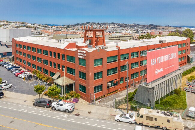
1485 Bay Shore Blvd, San Francisco, CA 94124


Current Lease Availabilities
NEARBY LISTINGS FOR SALE OR LEASE
Property Detail
1485 Bay Shore Blvd
San Francisco-Redwood City-South San Francisco, CA
Plan Of The Haley Purchase West
5431A-012
San Francisco
Officebuilding
California
2024
12
2025
3.72 AC
023300
Bayview/Hunters Point
109,856 SF
San Francisco
DEMOGRAPHICS near 1485 Bay Shore Blvd
1 Mile
3 Mile
5 Mile
2024 Total Population
45,138
260,523
709,696
2029 Population
40,647
238,938
657,558
Pop Growth 2024-2029
(9.95%)
(8.29%)
(7.35%)
Average Age
43
42
42
2024 Total Households
12,781
92,466
289,754
HH Growth 2024-2029
(10.54%)
(8.57%)
(7.71%)
Median Household Inc
$96,944
$130,508
$119,646
Avg Household Size
3.20
2.60
2.30
2024 Avg HH Vehicles
2.00
1.00
1.00
Median Home Value
$1,014,940
$1,080,276
$1,083,350
Median Year Built
1954
1949
1953
Nearby Places
Map Layers
Map Styles
 Street
 Aerial
- Restaurants
- Banks
- Shops
- Fitness
- Groceries
PUBLIC TRANSPORTATION
TRANSIT/SUBWAY
Gilman/Paul Station Inbound (T Third Street - San Francisco Municipal Railway (MUNI Metro))
DRIVE
WALK
Distance
Gilman/Paul Station Inbound (T Third Street - San Francisco Municipal Railway (MUNI Metro))
1 min
10 min
0.5 mi
Le Conte Station (T Third Street - San Francisco Municipal Railway (MUNI Metro))
DRIVE
WALK
Distance
Le Conte Station (T Third Street - San Francisco Municipal Railway (MUNI Metro))
2 min
12 min
0.7 mi
Third Street & Le Conte Ave (THIRD - San Francisco Municipal Transportation Agency)
DRIVE
WALK
Distance
Third Street & Le Conte Ave (THIRD - San Francisco Municipal Transportation Agency)
2 min
12 min
0.7 mi
Carroll Station Outbound (T Third Street - San Francisco Municipal Railway (MUNI Metro), THIRD - San Francisco Municipal Railway (MUNI Metro))
DRIVE
WALK
Distance
Carroll Station Outbound (T Third Street - San Francisco Municipal Railway (MUNI Metro), THIRD - San Francisco Municipal Railway (MUNI Metro))
2 min
13 min
0.7 mi
Williams Station Outbound (T Third Street - San Francisco Municipal Railway (MUNI Metro))
DRIVE
WALK
Distance
Williams Station Outbound (T Third Street - San Francisco Municipal Railway (MUNI Metro))
3 min
14 min
0.7 mi
COMMUTER RAIL
Bayshore Caltrain Station (Local - Caltrain (Caltrain), Local Weekday - Caltrain (Caltrain), Local Weekend - Caltrain (Caltrain))
DRIVE
WALK
Distance
Bayshore Caltrain Station (Local - Caltrain (Caltrain), Local Weekday - Caltrain (Caltrain), Local Weekend - Caltrain (Caltrain))
3 min
1.3 mi
22Nd Street (Caltrain - Caltrain (Caltrain))
DRIVE
WALK
Distance
22Nd Street (Caltrain - Caltrain (Caltrain))
8 min
5.0 mi
AIRPORT
San Francisco International
DRIVE
WALK
Distance
San Francisco International
14 min
9.1 mi
Metro Oakland International
DRIVE
WALK
Distance
Metro Oakland International
35 min
22.9 mi
Freight Ports
Port of San Francisco
DRIVE
WALK
Distance
Port of San Francisco
12 min
5.9 mi
Nearby Properties
Address
Land Use
TOTAL SIZE
Lot Size
Zoning
Address
Land Use
TOTAL SIZE
Lot Size
Zoning
750,370 SF
3.25 AC
MBR3
Address
Land Use
TOTAL SIZE
Lot Size
Zoning
248,303 SF
4.35 AC
Address
Land Use
TOTAL SIZE
Lot Size
Zoning
10.92 AC
Address
Land Use
TOTAL SIZE
Lot Size
Zoning
2.74 AC
Address
Land Use
TOTAL SIZE
Lot Size
Zoning
10.92 AC
Address
Land Use
TOTAL SIZE
Lot Size
Zoning
241,659 SF
3.76 AC
Address
Land Use
TOTAL SIZE
Lot Size
Zoning
230,853 SF
3.76 AC
Address
Land Use
TOTAL SIZE
Lot Size
Zoning
10.92 AC
Address
Land Use
TOTAL SIZE
Lot Size
Zoning
250,884 SF
1.66 AC
MB-RA
Address
Land Use
TOTAL SIZE
Lot Size
Zoning
2.22 AC
M1
Address
Land Use
TOTAL SIZE
Lot Size
Zoning
333,244 SF
2.67 AC
UMU
Address
Land Use
TOTAL SIZE
Lot Size
Zoning
347,857 SF
2.76 AC
Address
Land Use
TOTAL SIZE
Lot Size
Zoning
346,710 SF
7.45 AC
RH2
Address
Land Use
TOTAL SIZE
Lot Size
Zoning
167,053 SF
0.99 AC
MB-RA
Address
Land Use
TOTAL SIZE
Lot Size
Zoning
3.49 AC
Address
Land Use
TOTAL SIZE
Lot Size
Zoning
100,732 SF
4.55 AC
M2
Address
Land Use
TOTAL SIZE
Lot Size
Zoning
210,036 SF
23.85 AC
UMU
Address
Land Use
TOTAL SIZE
Lot Size
Zoning
243,176 SF
1.48 AC
UMU
Address
Land Use
TOTAL SIZE
Lot Size
Zoning
164,464 SF
1.05 AC
MB-RA
Address
Land Use
TOTAL SIZE
Lot Size
Zoning
231,687 SF
8.64 AC
Address
Land Use
TOTAL SIZE
Lot Size
Zoning
54,000 SF
1.67 AC
PDR2
Address
Land Use
TOTAL SIZE
Lot Size
Zoning
199,678 SF
1.06 AC
UMU
Address
Land Use
TOTAL SIZE
Lot Size
Zoning
157,256 SF
1.15 AC
M2
Address
Land Use
TOTAL SIZE
Lot Size
Zoning
439,294 SF
5.43 AC
PDR2
Address
Land Use
TOTAL SIZE
Lot Size
Zoning
147,000 SF
1.84 AC
UMU
Address
Land Use
TOTAL SIZE
Lot Size
Zoning
38,600 SF
0.89 AC
UMU
Address
Land Use
TOTAL SIZE
Lot Size
Zoning
1.37 AC
MB-RA
Address
Land Use
TOTAL SIZE
Lot Size
Zoning
Address
Land Use
TOTAL SIZE
Lot Size
Zoning
143,920 SF
7.29 AC
PDR2
Address
Land Use
TOTAL SIZE
Lot Size
Zoning
176,000 SF
1.84 AC
M1
The World's #1 Commercial Real Estate Marketplace
Connect with us
© 2026 CoStar Group
The information above has been obtained from sources believed reliable. While we do not doubt its accuracy we have not verified it and make no guarantee, warranty or representation about it. It is your responsibility to independently confirm its accuracy and completeness. Any projections, opinions, assumptions, or estimates used are for example only and do not represent the current or future performance of the property. The value of this transaction to you depends on tax and other factors which should be evaluated by your tax, financial, and legal advisors. You and your advisors should conduct a careful, independent investigation of the property to determine to your satisfaction the suitability of the property for your needs.