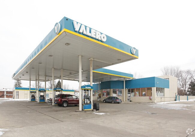
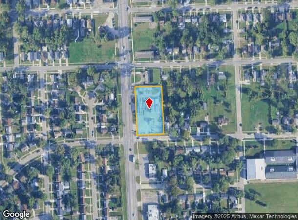
Property Record
1485 Middlebelt Rd, Inkster, MI 48141

NEARBY LISTINGS FOR SALE OR LEASE
Property Detail
1485 Middlebelt Rd
Detroit-Warren-Dearborn, MI
View Gardens
44-005-01-0235-302
*24J235A, 236A, 275A TO 278A* LOTS 235, 236, 275, 276, 277, AND 278 INCL EXC THE W 10FT THEREOF GRAND VIEW GARDENS SUB T2S R9E L45 P94 WCR
Conveniencestore
Wayne
X
Michigan
26163C0240F
0235
2024
1.98 AC
2025
Southern I-275 Corridor
570400
Detroit
6,538 SF
DEMOGRAPHICS near 1485 Middlebelt Rd
1 Mile
3 Mile
5 Mile
2024 Total Population
12,462
114,547
268,780
2029 Population
12,154
110,557
258,460
Pop Growth 2024-2029
(2.47%)
(3.48%)
(3.84%)
Average Age
38
39
40
2024 Total Households
4,709
44,619
108,727
HH Growth 2024-2029
(2.57%)
(3.56%)
(3.88%)
Median Household Inc
$50,106
$56,641
$60,955
Avg Household Size
2.50
2.50
2.40
2024 Avg HH Vehicles
2.00
2.00
2.00
Median Home Value
$111,844
$149,599
$158,368
Median Year Built
1957
1957
1957
Nearby Places
Map Layers
Map Styles
 Street
 Aerial
- Restaurants
- Banks
- Shops
- Fitness
- Groceries
PUBLIC TRANSPORTATION
COMMUTER RAIL
Dearborn (Wolverine - Amtrak)
DRIVE
WALK
Distance
Dearborn (Wolverine - Amtrak)
13 min
5.8 mi
AIRPORT
Detroit Metro Wayne County
DRIVE
WALK
Distance
Detroit Metro Wayne County
18 min
8.6 mi
Windsor International
DRIVE
WALK
Distance
Windsor International
52 min
31.4 mi
Freight Ports
Port of Toledo
DRIVE
WALK
Distance
Port of Toledo
73 min
56.2 mi
Nearby Properties
Address
Land Use
TOTAL SIZE
Lot Size
Zoning
Address
Land Use
TOTAL SIZE
Lot Size
Zoning
126,712 SF
4.52 AC
BC
Address
Land Use
TOTAL SIZE
Lot Size
Zoning
188,958 SF
7.71 AC
Address
Land Use
TOTAL SIZE
Lot Size
Zoning
463,642 SF
22.82 AC
Address
Land Use
TOTAL SIZE
Lot Size
Zoning
197,774 SF
11.72 AC
Address
Land Use
TOTAL SIZE
Lot Size
Zoning
328,480 SF
11.54 AC
IA
Address
Land Use
TOTAL SIZE
Lot Size
Zoning
196,930 SF
9.93 AC
Address
Land Use
TOTAL SIZE
Lot Size
Zoning
138,541 SF
8.65 AC
Address
Land Use
TOTAL SIZE
Lot Size
Zoning
467,594 SF
34.54 AC
IND-B IND
Address
Land Use
TOTAL SIZE
Lot Size
Zoning
99.86 AC
Address
Land Use
TOTAL SIZE
Lot Size
Zoning
142,269 SF
8.62 AC
Address
Land Use
TOTAL SIZE
Lot Size
Zoning
Address
Land Use
TOTAL SIZE
Lot Size
Zoning
58,958 SF
2.15 AC
BC
Address
Land Use
TOTAL SIZE
Lot Size
Zoning
127,017 SF
6.91 AC
Address
Land Use
TOTAL SIZE
Lot Size
Zoning
176,883 SF
10.83 AC
Address
Land Use
TOTAL SIZE
Lot Size
Zoning
93,425 SF
7.75 AC
Address
Land Use
TOTAL SIZE
Lot Size
Zoning
150,420 SF
11.83 AC
Address
Land Use
TOTAL SIZE
Lot Size
Zoning
171,414 SF
23.57 AC
Address
Land Use
TOTAL SIZE
Lot Size
Zoning
93,202 SF
25.98 AC
M1-LIG
Address
Land Use
TOTAL SIZE
Lot Size
Zoning
314,418 SF
28.06 AC
Address
Land Use
TOTAL SIZE
Lot Size
Zoning
103,706 SF
10.33 AC
Address
Land Use
TOTAL SIZE
Lot Size
Zoning
53,263 SF
2.80 AC
Address
Land Use
TOTAL SIZE
Lot Size
Zoning
50,974 SF
8.48 AC
Address
Land Use
TOTAL SIZE
Lot Size
Zoning
186,112 SF
13.42 AC
M1-LIG
Address
Land Use
TOTAL SIZE
Lot Size
Zoning
61,200 SF
10.10 AC
Address
Land Use
TOTAL SIZE
Lot Size
Zoning
110,371 SF
8.68 AC
Address
Land Use
TOTAL SIZE
Lot Size
Zoning
42,928 SF
4.88 AC
Address
Land Use
TOTAL SIZE
Lot Size
Zoning
111,699 SF
10.08 AC
Address
Land Use
TOTAL SIZE
Lot Size
Zoning
97,740 SF
4.47 AC
Address
Land Use
TOTAL SIZE
Lot Size
Zoning
99,831 SF
8.54 AC
Address
Land Use
TOTAL SIZE
Lot Size
Zoning
93,059 SF
26.53 AC
M-T
The World's #1 Commercial Real Estate Marketplace
Connect with us
© 2025 CoStar Group
The information above has been obtained from sources believed reliable. While we do not doubt its accuracy we have not verified it and make no guarantee, warranty or representation about it. It is your responsibility to independently confirm its accuracy and completeness. Any projections, opinions, assumptions, or estimates used are for example only and do not represent the current or future performance of the property. The value of this transaction to you depends on tax and other factors which should be evaluated by your tax, financial, and legal advisors. You and your advisors should conduct a careful, independent investigation of the property to determine to your satisfaction the suitability of the property for your needs.