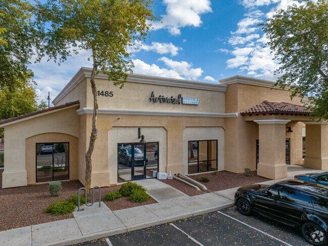
Property Record
1485 S Higley Rd, Gilbert, AZ 85296
Current Lease Availabilities
NEARBY LISTINGS FOR SALE OR LEASE
Property Detail
1485 S Higley Rd
Phoenix-Mesa-Chandler, AZ
Higley Park Commons Condominium Amd
304-28-781
HIGLEY PARK COMMONS CONDOMINIUM AMD MCR 963-26
Officecondo
Maricopa
X
Arizona
04013C2753M
7
2025
0.03 AC
2025
Gateway Airport/Loop 202
814802
Phoenix
8,617 SF
DEMOGRAPHICS near 1485 S Higley Rd
1 Mile
3 Mile
5 Mile
2024 Total Population
19,148
109,735
264,074
2029 Population
20,772
119,483
286,498
Pop Growth 2024-2029
+ 8.48%
+ 8.88%
+ 8.49%
Average Age
34
34
36
2024 Total Households
6,165
35,567
87,972
HH Growth 2024-2029
+ 8.52%
+ 9.13%
+ 8.67%
Median Household Inc
$112,236
$107,897
$103,168
Avg Household Size
3.10
3.00
2.90
2024 Avg HH Vehicles
2.00
2.00
2.00
Median Home Value
$423,779
$438,529
$439,039
Median Year Built
2007
2005
2001
Nearby Places
Map Layers
Map Styles
 Street
 Aerial
- Restaurants
- Banks
- Shops
- Fitness
- Groceries
PUBLIC TRANSPORTATION
AIRPORT
Phoenix-Mesa Gateway
DRIVE
WALK
Distance
Phoenix-Mesa Gateway
10 min
4.5 mi
Phoenix Sky Harbor International
DRIVE
WALK
Distance
Phoenix Sky Harbor International
36 min
24.8 mi
Nearby Properties
Address
Land Use
TOTAL SIZE
Lot Size
Zoning
Address
Land Use
TOTAL SIZE
Lot Size
Zoning
Address
Land Use
TOTAL SIZE
Lot Size
Zoning
93,214 SF
10.60 AC
PF
Address
Land Use
TOTAL SIZE
Lot Size
Zoning
862,568 SF
420.15 AC
PS
Address
Land Use
TOTAL SIZE
Lot Size
Zoning
12.66 AC
Address
Land Use
TOTAL SIZE
Lot Size
Zoning
604,432 SF
56.74 AC
PF
Address
Land Use
TOTAL SIZE
Lot Size
Zoning
2.91 AC
Address
Land Use
TOTAL SIZE
Lot Size
Zoning
580,492 SF
41.81 AC
R3
Address
Land Use
TOTAL SIZE
Lot Size
Zoning
298,703 SF
57.08 AC
PF
Address
Land Use
TOTAL SIZE
Lot Size
Zoning
479,727 SF
14.25 AC
MFM
Address
Land Use
TOTAL SIZE
Lot Size
Zoning
245,425 SF
205.62 AC
I-1
Address
Land Use
TOTAL SIZE
Lot Size
Zoning
412,581 SF
21.15 AC
MFM
Address
Land Use
TOTAL SIZE
Lot Size
Zoning
4.60 AC
C-C
Address
Land Use
TOTAL SIZE
Lot Size
Zoning
396,754 SF
46.84 AC
PF
Address
Land Use
TOTAL SIZE
Lot Size
Zoning
414,288 SF
28.67 AC
LI
Address
Land Use
TOTAL SIZE
Lot Size
Zoning
348,668 SF
8.97 AC
R3
Address
Land Use
TOTAL SIZE
Lot Size
Zoning
238,386 SF
40.25 AC
BP
Address
Land Use
TOTAL SIZE
Lot Size
Zoning
387,535 SF
15.80 AC
C-G
Address
Land Use
TOTAL SIZE
Lot Size
Zoning
380,383 SF
14.79 AC
C-G
Address
Land Use
TOTAL SIZE
Lot Size
Zoning
323,064 SF
15.90 AC
MFM
Address
Land Use
TOTAL SIZE
Lot Size
Zoning
362,701 SF
9.77 AC
R3
Address
Land Use
TOTAL SIZE
Lot Size
Zoning
278,044 SF
19.98 AC
PF
Address
Land Use
TOTAL SIZE
Lot Size
Zoning
308,343 SF
13.90 AC
MFM
Address
Land Use
TOTAL SIZE
Lot Size
Zoning
266,467 SF
47.47 AC
PF
Address
Land Use
TOTAL SIZE
Lot Size
Zoning
274,993 SF
16.44 AC
Address
Land Use
TOTAL SIZE
Lot Size
Zoning
332,112 SF
15.44 AC
M-M
Address
Land Use
TOTAL SIZE
Lot Size
Zoning
275,813 SF
24.90 AC
R-CH
Address
Land Use
TOTAL SIZE
Lot Size
Zoning
316,979 SF
17.26 AC
MF/M
Address
Land Use
TOTAL SIZE
Lot Size
Zoning
283,393 SF
6 AC
GVC
Address
Land Use
TOTAL SIZE
Lot Size
Zoning
63,507 SF
83.58 AC
PF
Address
Land Use
TOTAL SIZE
Lot Size
Zoning
143,232 SF
26.94 AC
PF
The World's #1 Commercial Real Estate Marketplace
Connect with us
© 2026 CoStar Group
The information above has been obtained from sources believed reliable. While we do not doubt its accuracy we have not verified it and make no guarantee, warranty or representation about it. It is your responsibility to independently confirm its accuracy and completeness. Any projections, opinions, assumptions, or estimates used are for example only and do not represent the current or future performance of the property. The value of this transaction to you depends on tax and other factors which should be evaluated by your tax, financial, and legal advisors. You and your advisors should conduct a careful, independent investigation of the property to determine to your satisfaction the suitability of the property for your needs.