Property Record
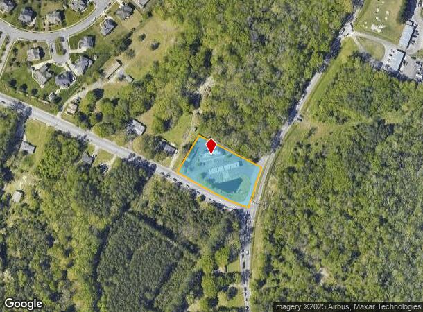
1488 Butts Station Rd, Chesapeake, VA 23320
NEARBY LISTINGS FOR SALE OR LEASE
-
-
View all Chesapeake listings for sale on LoopNet.com
Property Detail
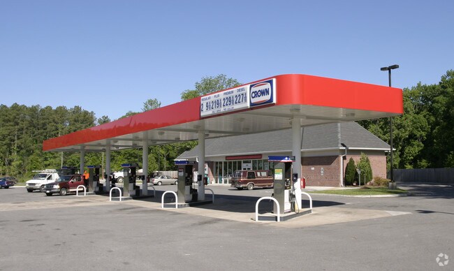
1488 Butts Station Rd
0490000001390
Kempsville Road Corridor
Conveniencestore
2 RALPH D MOULTON PROP 1.438 AC
AE
Chesapeake
5100340039D
Virginia
2024
1.44 AC
2025
Great Bridge
020804
Hampton Roads
3,570 SF
Virginia Beach-Norfolk-Newport News, VA-NC
DEMOGRAPHICS near 1488 Butts Station Rd
1 Mile
3 Mile
5 Mile
2024 Total Population
2,788
45,637
152,098
2029 Population
2,902
46,498
154,099
Pop Growth 2024-2029
+ 4.09%
+ 1.89%
+ 1.32%
Average Age
39
40
39
2024 Total Households
952
16,597
56,032
HH Growth 2024-2029
+ 4.20%
+ 2.02%
+ 1.42%
Median Household Inc
$141,032
$108,933
$98,596
Avg Household Size
2.80
2.70
2.60
2024 Avg HH Vehicles
2.00
2.00
2.00
Median Home Value
$473,164
$367,090
$339,598
Median Year Built
2010
1993
1989
Nearby Places
Map Layers
Map Styles
 Street
 Aerial
- Restaurants
- Banks
- Shops
- Fitness
- Groceries
PUBLIC TRANSPORTATION
AIRPORT
Norfolk International
DRIVE
WALK
Distance
Norfolk International
24 min
13.7 mi
Freight Ports
Virginia Port Authority - Portsmouth
DRIVE
WALK
Distance
Virginia Port Authority - Portsmouth
30 min
16.6 mi
Nearby Properties
Address
Land Use
TOTAL SIZE
Lot Size
Zoning
Address
Land Use
TOTAL SIZE
Lot Size
Zoning
10.36 AC
A24
Address
Land Use
TOTAL SIZE
Lot Size
Zoning
145,522 SF
15.51 AC
PUD: PLANN
Address
Land Use
TOTAL SIZE
Lot Size
Zoning
71,711 SF
11.65 AC
B4
Address
Land Use
TOTAL SIZE
Lot Size
Zoning
3 SF
19.50 AC
A12
Address
Land Use
TOTAL SIZE
Lot Size
Zoning
218,812 SF
45.15 AC
PUD: PLANN
Address
Land Use
TOTAL SIZE
Lot Size
Zoning
140,369 SF
10.35 AC
PUD: PLANN
Address
Land Use
TOTAL SIZE
Lot Size
Zoning
16.03 AC
A24
Address
Land Use
TOTAL SIZE
Lot Size
Zoning
188,683 SF
13.14 AC
O-I: OFFIC
Address
Land Use
TOTAL SIZE
Lot Size
Zoning
422.43 AC
PUD: PLANN
Address
Land Use
TOTAL SIZE
Lot Size
Zoning
19,962 SF
52.38 AC
PUD: PLANN
Address
Land Use
TOTAL SIZE
Lot Size
Zoning
175,028 SF
12.41 AC
RMF1: MULT
Address
Land Use
TOTAL SIZE
Lot Size
Zoning
1,188 SF
73.88 AC
A1: AGRICU
Address
Land Use
TOTAL SIZE
Lot Size
Zoning
190,194 SF
12.40 AC
RMF1: MULT
Address
Land Use
TOTAL SIZE
Lot Size
Zoning
27,696 SF
15.80 AC
B1: NEIGHB
Address
Land Use
TOTAL SIZE
Lot Size
Zoning
129,138 SF
8.86 AC
RMF1: MULT
Address
Land Use
TOTAL SIZE
Lot Size
Zoning
50,978 SF
10.43 AC
B2: GENERA
Address
Land Use
TOTAL SIZE
Lot Size
Zoning
59,892 SF
6.71 AC
PUD: PLANN
Address
Land Use
TOTAL SIZE
Lot Size
Zoning
269.85 AC
MULTI: MUL
Address
Land Use
TOTAL SIZE
Lot Size
Zoning
22,680 SF
7.97 AC
PUD: PLANN
Address
Land Use
TOTAL SIZE
Lot Size
Zoning
36,291 SF
10.82 AC
O-I: OFFIC
Address
Land Use
TOTAL SIZE
Lot Size
Zoning
35,962 SF
15.91 AC
B2: GENERA
Address
Land Use
TOTAL SIZE
Lot Size
Zoning
21,126 SF
36.51 AC
A1: AGRICU
Address
Land Use
TOTAL SIZE
Lot Size
Zoning
69,030 SF
14.81 AC
PUD: PLANN
Address
Land Use
TOTAL SIZE
Lot Size
Zoning
88,567 SF
15 AC
R15S: RESI
Address
Land Use
TOTAL SIZE
Lot Size
Zoning
66,978 SF
14.61 AC
RMF1: MULT
Address
Land Use
TOTAL SIZE
Lot Size
Zoning
95,106 SF
5.12 AC
R15S: RESI
Address
Land Use
TOTAL SIZE
Lot Size
Zoning
2,168 SF
7.93 AC
O-I: OFFIC
Address
Land Use
TOTAL SIZE
Lot Size
Zoning
40,337 SF
23.62 AC
AC: ASSEMB
Address
Land Use
TOTAL SIZE
Lot Size
Zoning
9,216 SF
3.30 AC
B2: GENERA
Address
Land Use
TOTAL SIZE
Lot Size
Zoning
31,479 SF
4.95 AC
O-I: OFFIC
The World's #1 Commercial Real Estate Marketplace
Connect with us
© 2025 CoStar Group
The information above has been obtained from sources believed reliable. While we do not doubt its accuracy we have not verified it and make no guarantee, warranty or representation about it. It is your responsibility to independently confirm its accuracy and completeness. Any projections, opinions, assumptions, or estimates used are for example only and do not represent the current or future performance of the property. The value of this transaction to you depends on tax and other factors which should be evaluated by your tax, financial, and legal advisors. You and your advisors should conduct a careful, independent investigation of the property to determine to your satisfaction the suitability of the property for your needs.