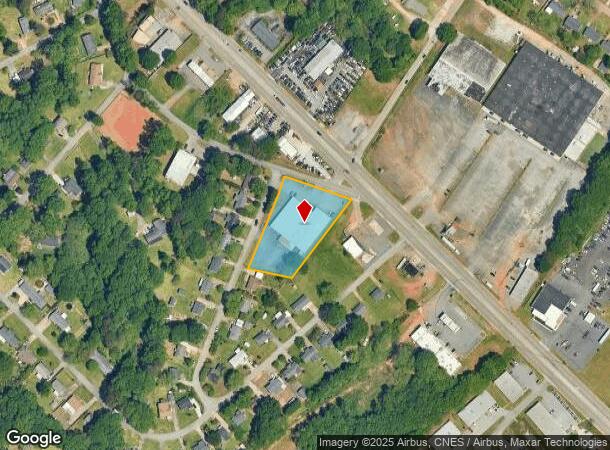
Property Record
1489 Cedar Lane Rd, Greenville, SC 29617
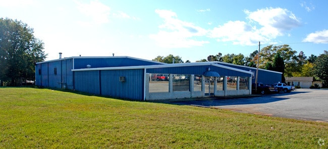
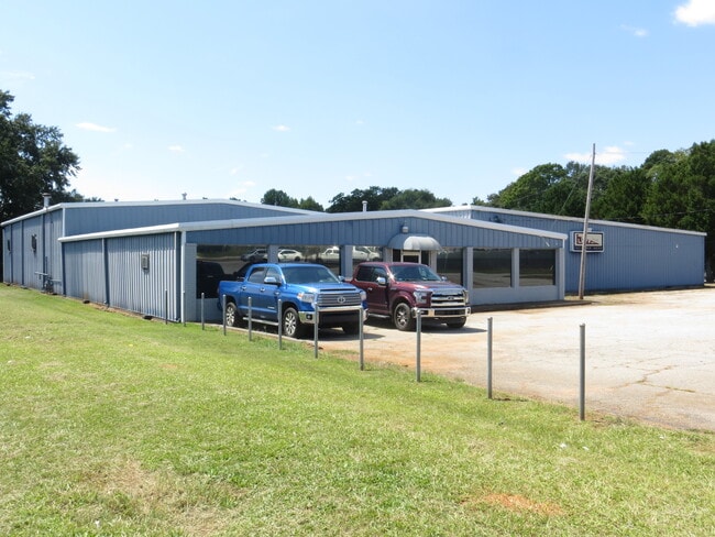
This Property Is For Sale
NEARBY LISTINGS FOR SALE OR LEASE
Property Detail
1489 Cedar Lane Rd
Greenville-Anderson-Mauldin, SC
Oak Hill
B012.00-01-145.00
NONE SECA
Warehouse
Greenville
X
South Carolina
45045C0314E
145.00
2024
1.24 AC
2024
West Greenville
003704
Greenville/Spartanburg
DEMOGRAPHICS near 1489 Cedar Lane Rd
1 Mile
3 Mile
5 Mile
2024 Total Population
9,497
64,249
137,501
2029 Population
10,494
71,459
152,421
Pop Growth 2024-2029
+ 10.50%
+ 11.22%
+ 10.85%
Average Age
37
38
38
2024 Total Households
3,346
25,941
56,149
HH Growth 2024-2029
+ 10.58%
+ 11.33%
+ 11.19%
Median Household Inc
$35,772
$42,941
$51,041
Avg Household Size
2.60
2.40
2.30
2024 Avg HH Vehicles
2.00
2.00
2.00
Median Home Value
$112,679
$169,241
$226,215
Median Year Built
1975
1979
1980
Nearby Places
- Restaurants
- Banks
- Shops
- Fitness
- Groceries
PUBLIC TRANSPORTATION
COMMUTER RAIL
Greenville Amtrak Station (Crescent - Amtrak)
DRIVE
WALK
Distance
Greenville Amtrak Station (Crescent - Amtrak)
6 min
2.7 mi
AIRPORT
Greenville Spartanburg International
DRIVE
WALK
Distance
Greenville Spartanburg International
29 min
17.2 mi
Freight Ports
North Charleston Terminal
DRIVE
WALK
Distance
North Charleston Terminal
236 min
207.8 mi
Nearby Properties
Address
Land Use
TOTAL SIZE
Lot Size
Zoning
Address
Land Use
TOTAL SIZE
Lot Size
Zoning
22.97 AC
R12
Address
Land Use
TOTAL SIZE
Lot Size
Zoning
28.88 AC
RM
Address
Land Use
TOTAL SIZE
Lot Size
Zoning
14.41 AC
R15
Address
Land Use
TOTAL SIZE
Lot Size
Zoning
20.04 AC
RM
Address
Land Use
TOTAL SIZE
Lot Size
Zoning
1.62 AC
C3
Address
Land Use
TOTAL SIZE
Lot Size
Zoning
9.57 AC
C3
Address
Land Use
TOTAL SIZE
Lot Size
Zoning
10.10 AC
RM
Address
Land Use
TOTAL SIZE
Lot Size
Zoning
5.07 AC
S1
Address
Land Use
TOTAL SIZE
Lot Size
Zoning
14.85 AC
S1
Address
Land Use
TOTAL SIZE
Lot Size
Zoning
954 SF
7.83 AC
S1
Address
Land Use
TOTAL SIZE
Lot Size
Zoning
2.71 AC
RM2
Address
Land Use
TOTAL SIZE
Lot Size
Zoning
27.38 AC
R75
Address
Land Use
TOTAL SIZE
Lot Size
Zoning
5.40 AC
OD
Address
Land Use
TOTAL SIZE
Lot Size
Zoning
3.43 AC
CBD
Address
Land Use
TOTAL SIZE
Lot Size
Zoning
2.14 AC
RM
Address
Land Use
TOTAL SIZE
Lot Size
Zoning
2.12 AC
S1
Address
Land Use
TOTAL SIZE
Lot Size
Zoning
2.21 AC
RMA
Address
Land Use
TOTAL SIZE
Lot Size
Zoning
1.90 AC
C3
Address
Land Use
TOTAL SIZE
Lot Size
Zoning
50.95 AC
R75
Address
Land Use
TOTAL SIZE
Lot Size
Zoning
3.07 AC
C3
Address
Land Use
TOTAL SIZE
Lot Size
Zoning
7.29 AC
S1
Address
Land Use
TOTAL SIZE
Lot Size
Zoning
8.29 AC
I1
Address
Land Use
TOTAL SIZE
Lot Size
Zoning
4.97 AC
RM20
Address
Land Use
TOTAL SIZE
Lot Size
Zoning
9.87 AC
S1
Address
Land Use
TOTAL SIZE
Lot Size
Zoning
32.18 AC
C2
Address
Land Use
TOTAL SIZE
Lot Size
Zoning
15.60 AC
I1
Address
Land Use
TOTAL SIZE
Lot Size
Zoning
30.52 AC
C2
Address
Land Use
TOTAL SIZE
Lot Size
Zoning
22.92 AC
R10
Address
Land Use
TOTAL SIZE
Lot Size
Zoning
8.40 AC
I1
Address
Land Use
TOTAL SIZE
Lot Size
Zoning
1.08 AC
C3
The World's #1 Commercial Real Estate Marketplace
Connect with us
© 2025 CoStar Group
The information above has been obtained from sources believed reliable. While we do not doubt its accuracy we have not verified it and make no guarantee, warranty or representation about it. It is your responsibility to independently confirm its accuracy and completeness. Any projections, opinions, assumptions, or estimates used are for example only and do not represent the current or future performance of the property. The value of this transaction to you depends on tax and other factors which should be evaluated by your tax, financial, and legal advisors. You and your advisors should conduct a careful, independent investigation of the property to determine to your satisfaction the suitability of the property for your needs.