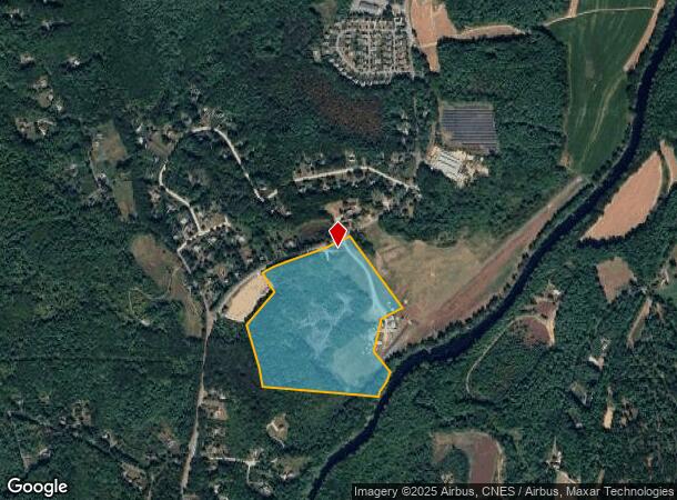
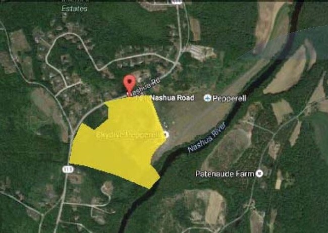
Property Record
141 Nashua Rd, Pepperell, MA 01463

NEARBY LISTINGS FOR SALE OR LEASE
-
-
View all Pepperell listings for sale on LoopNet.com
Property Detail
141 Nashua Rd
PEPP-000006-000020
Middlesex
Multipleuses
Massachusetts
A
42.06 AC
25017C0083F
Groton/Townsend
2025
Boston
2025
Boston-Cambridge-Newton, MA-NH
327101
DEMOGRAPHICS near 141 Nashua Rd
1 Mile
3 Mile
5 Mile
2024 Total Population
1,267
14,443
54,428
2029 Population
1,258
14,404
54,902
Pop Growth 2024-2029
(0.71%)
(0.27%)
+ 0.87%
Average Age
43
43
43
2024 Total Households
455
5,531
21,243
HH Growth 2024-2029
(0.66%)
(0.33%)
+ 0.88%
Median Household Inc
$147,077
$117,779
$115,380
Avg Household Size
2.80
2.60
2.50
2024 Avg HH Vehicles
2.00
2.00
2.00
Median Home Value
$488,094
$442,484
$416,226
Median Year Built
1991
1980
1981
Nearby Places
- Restaurants
- Banks
- Shops
- Fitness
- Groceries
PUBLIC TRANSPORTATION
AIRPORT
Manchester Boston Regional
DRIVE
WALK
Distance
Manchester Boston Regional
34 min
20.6 mi
Freight Ports
Port of Boston
DRIVE
WALK
Distance
Port of Boston
76 min
53.3 mi
SALE & LEASE HISTORY
LISTING DATE
SALE/LEASE

Sep 24, 2016
For Sale
Nearby Properties
Address
Land Use
TOTAL SIZE
Lot Size
Zoning
Address
Land Use
TOTAL SIZE
Lot Size
Zoning
127,577 SF
77.91 AC
TNR
Address
Land Use
TOTAL SIZE
Lot Size
Zoning
129,435 SF
29.90 AC
TNR
Address
Land Use
TOTAL SIZE
Lot Size
Zoning
5.02 AC
SUR
Address
Land Use
TOTAL SIZE
Lot Size
Zoning
1,440 SF
111.23 AC
R9
Address
Land Use
TOTAL SIZE
Lot Size
Zoning
80,953 SF
2.60 AC
TNR
Address
Land Use
TOTAL SIZE
Lot Size
Zoning
8.32 AC
URR
Address
Land Use
TOTAL SIZE
Lot Size
Zoning
297.34 AC
R30
Address
Land Use
TOTAL SIZE
Lot Size
Zoning
64,987 SF
58 AC
R30
Address
Land Use
TOTAL SIZE
Lot Size
Zoning
12.43 AC
R40
Address
Land Use
TOTAL SIZE
Lot Size
Zoning
9.16 AC
IND
Address
Land Use
TOTAL SIZE
Lot Size
Zoning
2.88 AC
COM
Address
Land Use
TOTAL SIZE
Lot Size
Zoning
13.19 AC
SUR
Address
Land Use
TOTAL SIZE
Lot Size
Zoning
180,434 SF
10.94 AC
IND
Address
Land Use
TOTAL SIZE
Lot Size
Zoning
6.46 AC
COM
Address
Land Use
TOTAL SIZE
Lot Size
Zoning
12.07 AC
R40
Address
Land Use
TOTAL SIZE
Lot Size
Zoning
6.69 AC
R30
Address
Land Use
TOTAL SIZE
Lot Size
Zoning
3,023 SF
16 AC
RA
Address
Land Use
TOTAL SIZE
Lot Size
Zoning
2.73 AC
COM
Address
Land Use
TOTAL SIZE
Lot Size
Zoning
2,307 SF
1.50 AC
URR
Address
Land Use
TOTAL SIZE
Lot Size
Zoning
175.67 AC
RUR
Address
Land Use
TOTAL SIZE
Lot Size
Zoning
80.04 AC
R40
Address
Land Use
TOTAL SIZE
Lot Size
Zoning
41,336 SF
3.90 AC
IND
Address
Land Use
TOTAL SIZE
Lot Size
Zoning
9,634 SF
R30
Address
Land Use
TOTAL SIZE
Lot Size
Zoning
23,720 SF
4.19 AC
IN
Address
Land Use
TOTAL SIZE
Lot Size
Zoning
12,254 SF
1.60 AC
TNR
Address
Land Use
TOTAL SIZE
Lot Size
Zoning
34,620 SF
6.02 AC
IN
Address
Land Use
TOTAL SIZE
Lot Size
Zoning
16,939 SF
1 AC
URR
Address
Land Use
TOTAL SIZE
Lot Size
Zoning
25,400 SF
9.30 AC
IND
Address
Land Use
TOTAL SIZE
Lot Size
Zoning
12,678 SF
1.31 AC
TNR
The World's #1 Commercial Real Estate Marketplace
Connect with us
© 2025 CoStar Group
The information above has been obtained from sources believed reliable. While we do not doubt its accuracy we have not verified it and make no guarantee, warranty or representation about it. It is your responsibility to independently confirm its accuracy and completeness. Any projections, opinions, assumptions, or estimates used are for example only and do not represent the current or future performance of the property. The value of this transaction to you depends on tax and other factors which should be evaluated by your tax, financial, and legal advisors. You and your advisors should conduct a careful, independent investigation of the property to determine to your satisfaction the suitability of the property for your needs.