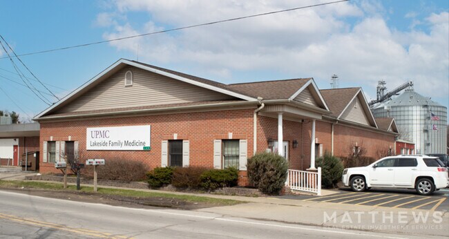
Property Record
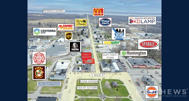
149 E Main St, Andover, OH 44003
Property Detail
149 E Main St
020132011500
25 SUB 4
Retirementnursinghomecombined
ASHTABULA
B and X Area of moderate flood hazard, usually the area between the limits of the 100-year and 500-year floods.
Ohio
2024
0.08 AC
2024
Ashtabula County
001304
Cleveland
3,718 SF
Cleveland-Elyria, OH
NEARBY LISTINGS FOR SALE OR LEASE
-
-
View all Andover listings for sale on LoopNet.com
DEMOGRAPHICS near 149 E Main St
1 mile
3 mile
5 mile
2024 Total Population
895
2,181
5,493
2029 Population
851
2,084
5,535
Pop Growth 2024-2029
(4.92%)
(4.45%)
+ 0.76%
Average Age
45
45
47
2024 Total Households
356
891
2,421
HH Growth 2024-2029
(5.62%)
(4.83%)
+ 1.12%
Median Household Inc
$55,333
$57,263
$57,747
Avg Household Size
2.30
2.30
2.20
2024 Avg HH Vehicles
2.00
2.00
2.00
Median Home Value
$125,000
$136,813
$145,928
Median Year Built
1970
1975
1976
Nearby Places
Map Layers
Map Styles
 Street
 Aerial
Transit
 Traffic
 Biking
Places
Listings with unknown addresses are not visible on the map
- Restaurants
- Banks
- Shops
- Fitness
- Groceries
PUBLIC TRANSPORTATION
AIRPORT
Erie International/Tom Ridge Field
Drive
Walk
Distance
Erie International/Tom Ridge Field
69 min
48.4 mi
SALE & LEASE HISTORY
LISTING DATE
SALE/LEASE

Apr 22, 2022
For Sale
Nearby Properties
Address
Land Use
TOTAL SIZE
Lot Size
Zoning
Address
Land Use
TOTAL SIZE
Lot Size
Zoning
291,039 SF
51.97 AC
Address
Land Use
TOTAL SIZE
Lot Size
Zoning
Address
Land Use
TOTAL SIZE
Lot Size
Zoning
Address
Land Use
TOTAL SIZE
Lot Size
Zoning
747.20 AC
Address
Land Use
TOTAL SIZE
Lot Size
Zoning
725.25 AC
Address
Land Use
TOTAL SIZE
Lot Size
Zoning
712.28 AC
Address
Land Use
TOTAL SIZE
Lot Size
Zoning
Address
Land Use
TOTAL SIZE
Lot Size
Zoning
36,821 SF
3.37 AC
Address
Land Use
TOTAL SIZE
Lot Size
Zoning
Address
Land Use
TOTAL SIZE
Lot Size
Zoning
24,714 SF
0.31 AC
Address
Land Use
TOTAL SIZE
Lot Size
Zoning
27,360 SF
3.37 AC
Address
Land Use
TOTAL SIZE
Lot Size
Zoning
15,139 SF
5.47 AC
Address
Land Use
TOTAL SIZE
Lot Size
Zoning
49.49 AC
Address
Land Use
TOTAL SIZE
Lot Size
Zoning
68,025 SF
15.74 AC
Address
Land Use
TOTAL SIZE
Lot Size
Zoning
1.81 AC
Address
Land Use
TOTAL SIZE
Lot Size
Zoning
23,136 SF
2.66 AC
Address
Land Use
TOTAL SIZE
Lot Size
Zoning
27,037 SF
1.87 AC
Address
Land Use
TOTAL SIZE
Lot Size
Zoning
79,300 SF
7.02 AC
Address
Land Use
TOTAL SIZE
Lot Size
Zoning
24,900 SF
7.23 AC
Address
Land Use
TOTAL SIZE
Lot Size
Zoning
3,274 SF
153.07 AC
Address
Land Use
TOTAL SIZE
Lot Size
Zoning
8,092 SF
82.49 AC
Address
Land Use
TOTAL SIZE
Lot Size
Zoning
5,137 SF
26.49 AC
Address
Land Use
TOTAL SIZE
Lot Size
Zoning
19,188 SF
2.07 AC
Address
Land Use
TOTAL SIZE
Lot Size
Zoning
3,824 SF
49.56 AC
Address
Land Use
TOTAL SIZE
Lot Size
Zoning
3,240 SF
121.65 AC
Address
Land Use
TOTAL SIZE
Lot Size
Zoning
1,400 SF
1.72 AC
Address
Land Use
TOTAL SIZE
Lot Size
Zoning
9,078 SF
0.34 AC
Address
Land Use
TOTAL SIZE
Lot Size
Zoning
1,344 SF
159.46 AC
Address
Land Use
TOTAL SIZE
Lot Size
Zoning
5,786 SF
46 AC
Address
Land Use
TOTAL SIZE
Lot Size
Zoning
1,880 SF
202.23 AC
The World's #1 Commercial Real Estate Marketplace
Connect with us
© 2026 CoStar Group
The information above has been obtained from sources believed reliable. While we do not doubt its accuracy we have not verified it and make no guarantee, warranty or representation about it. It is your responsibility to independently confirm its accuracy and completeness. Any projections, opinions, assumptions, or estimates used are for example only and do not represent the current or future performance of the property. The value of this transaction to you depends on tax and other factors which should be evaluated by your tax, financial, and legal advisors. You and your advisors should conduct a careful, independent investigation of the property to determine to your satisfaction the suitability of the property for your needs.