Property Record
149 Main St, Rockfall, CT 06481
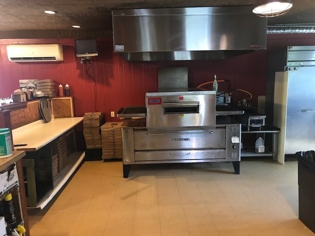

Property Detail
149 Main St
MFLD-000009-000000-000163
Lower Ct River Vly
Commercialbuilding
Connecticut
PC
163
VE and V1-30 Coastal areas with a 1% or greater chance of flooding and an additional hazard associated with storm waves. These areas have a 26% chance of flooding over the life of a 30-year mortgage.
0.12 AC
2025
NW Middlesex/Middletown
2025
Hartford
580100
Hartford-West Hartford-East Hartford, CT
1,040 SF
NEARBY LISTINGS FOR SALE OR LEASE
DEMOGRAPHICS near 149 Main St
1 mile
3 mile
5 mile
2025 Total Population
1,856
28,865
81,064
2030 Population
1,864
29,093
81,621
Pop Growth 2025-2030
+ 0.43%
+ 0.79%
+ 0.69%
Average Age
45
42
42
2025 Total Households
756
11,573
33,318
HH Growth 2025-2030
+ 0.40%
+ 0.69%
+ 0.60%
Median Household Inc
$127,261
$78,404
$78,542
Avg Household Size
2.40
2.20
2.20
2025 Avg HH Vehicles
2.00
2.00
2.00
Median Home Value
$388,960
$324,026
$291,018
Median Year Built
1969
1966
1969
Nearby Places
Map Layers
Map Styles
 Street
 Aerial
Transit
 Traffic
 Biking
Places
Listings with unknown addresses are not visible on the map
- Restaurants
- Banks
- Shops
- Fitness
- Groceries
PUBLIC TRANSPORTATION
COMMUTER RAIL
Drive
Walk
Distance
14 min
7.7 mi
AIRPORT
Tweed/New Haven
Drive
Walk
Distance
Tweed/New Haven
42 min
26.2 mi
Bradley International
Drive
Walk
Distance
Bradley International
58 min
36.9 mi
Freight Ports
Port of New Haven
Drive
Walk
Distance
Port of New Haven
37 min
23.9 mi
SALE & LEASE HISTORY
LISTING DATE
SALE/LEASE

Aug 24, 2019
For Sale
Nearby Properties
Address
Land Use
TOTAL SIZE
Lot Size
Zoning
Address
Land Use
TOTAL SIZE
Lot Size
Zoning
12.12 AC
RPZ
Address
Land Use
TOTAL SIZE
Lot Size
Zoning
197,789 SF
31.92 AC
R-15
Address
Land Use
TOTAL SIZE
Lot Size
Zoning
2.33 AC
ID
Address
Land Use
TOTAL SIZE
Lot Size
Zoning
267,588 SF
12.34 AC
ID
Address
Land Use
TOTAL SIZE
Lot Size
Zoning
108,540 SF
22.99 AC
R-15
Address
Land Use
TOTAL SIZE
Lot Size
Zoning
4.90 AC
ID
Address
Land Use
TOTAL SIZE
Lot Size
Zoning
7.79 AC
ID
Address
Land Use
TOTAL SIZE
Lot Size
Zoning
23.01 AC
M
Address
Land Use
TOTAL SIZE
Lot Size
Zoning
1.62 AC
ID
Address
Land Use
TOTAL SIZE
Lot Size
Zoning
65,615 SF
1.46 AC
ID
Address
Land Use
TOTAL SIZE
Lot Size
Zoning
92,766 SF
1.79 AC
ID
Address
Land Use
TOTAL SIZE
Lot Size
Zoning
3.58 AC
DVD
Address
Land Use
TOTAL SIZE
Lot Size
Zoning
3.24 AC
ID
Address
Land Use
TOTAL SIZE
Lot Size
Zoning
2.49 AC
ID
Address
Land Use
TOTAL SIZE
Lot Size
Zoning
6.76 AC
M
Address
Land Use
TOTAL SIZE
Lot Size
Zoning
91.69 AC
R-15
Address
Land Use
TOTAL SIZE
Lot Size
Zoning
67,405 SF
25 AC
R-15
Address
Land Use
TOTAL SIZE
Lot Size
Zoning
10.10 AC
M
Address
Land Use
TOTAL SIZE
Lot Size
Zoning
3.25 AC
ID
Address
Land Use
TOTAL SIZE
Lot Size
Zoning
61,042 SF
4.40 AC
RPZ
Address
Land Use
TOTAL SIZE
Lot Size
Zoning
10.92 AC
B-2
Address
Land Use
TOTAL SIZE
Lot Size
Zoning
54,264 SF
15 AC
PRD
Address
Land Use
TOTAL SIZE
Lot Size
Zoning
2.98 AC
ID
Address
Land Use
TOTAL SIZE
Lot Size
Zoning
2.75 AC
ID
Address
Land Use
TOTAL SIZE
Lot Size
Zoning
14.65 AC
M
Address
Land Use
TOTAL SIZE
Lot Size
Zoning
50,533 SF
33 AC
R-30
Address
Land Use
TOTAL SIZE
Lot Size
Zoning
63,213 SF
5.32 AC
B-2
Address
Land Use
TOTAL SIZE
Lot Size
Zoning
50,273 SF
16.20 AC
R-15
Address
Land Use
TOTAL SIZE
Lot Size
Zoning
19,161 SF
0.82 AC
DVD
Address
Land Use
TOTAL SIZE
Lot Size
Zoning
110,708 SF
2.99 AC
MXC
The World's #1 Commercial Real Estate Marketplace
Connect with us
© 2026 CoStar Group
The information above has been obtained from sources believed reliable. While we do not doubt its accuracy we have not verified it and make no guarantee, warranty or representation about it. It is your responsibility to independently confirm its accuracy and completeness. Any projections, opinions, assumptions, or estimates used are for example only and do not represent the current or future performance of the property. The value of this transaction to you depends on tax and other factors which should be evaluated by your tax, financial, and legal advisors. You and your advisors should conduct a careful, independent investigation of the property to determine to your satisfaction the suitability of the property for your needs.