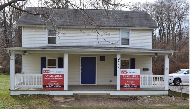
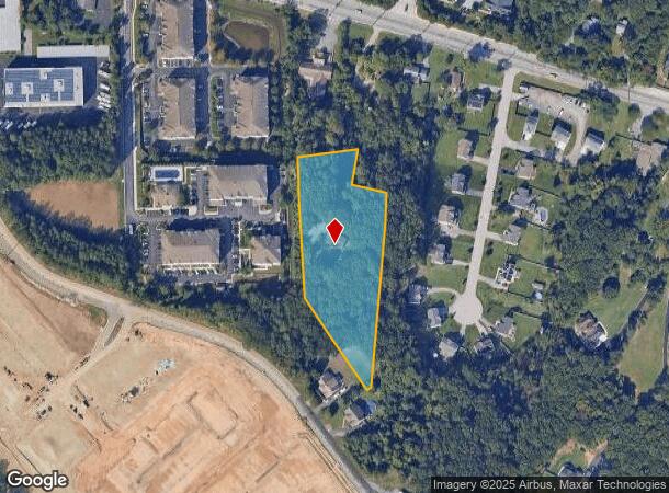
Property Record
149 Mountain Rd, Pasadena, MD 21122
NEARBY LISTINGS FOR SALE OR LEASE
Property Detail
149 Mountain Rd
03-000-29271150
Lipins Corner
Sfr
3 ACRES LIPINS CORNER
X
Anne Arundel
24003C0064F
Maryland
2024
3 AC
2025
Route 2 Corridor North
731209
Baltimore
2,256 SF
Baltimore-Columbia-Towson, MD
DEMOGRAPHICS near 149 Mountain Rd
1 mile
3 mile
5 mile
2024 Total Population
8,601
95,288
187,103
2029 Population
8,856
97,497
191,416
Pop Growth 2024-2029
+ 2.96%
+ 2.32%
+ 2.31%
Average Age
39
39
40
2024 Total Households
3,573
35,454
69,203
HH Growth 2024-2029
+ 3.08%
+ 2.39%
+ 2.35%
Median Household Inc
$88,598
$99,331
$103,928
Avg Household Size
2.40
2.60
2.60
2024 Avg HH Vehicles
2.00
2.00
2.00
Median Home Value
$367,827
$365,908
$381,149
Median Year Built
1993
1981
1978
Nearby Places
Map Layers
Map Styles
 Street
 Aerial
Transit
 Traffic
 Biking
Places
Listings with unknown addresses are not visible on the map
- Restaurants
- Banks
- Shops
- Fitness
- Groceries
PUBLIC TRANSPORTATION
AIRPORT
Baltimore/Washington International Thurgood Marshall
Drive
Walk
Distance
Baltimore/Washington International Thurgood Marshall
19 min
10.2 mi
Ronald Reagan Washington Ntl
Drive
Walk
Distance
Ronald Reagan Washington Ntl
65 min
42.6 mi
Freight Ports
Port of Baltimore
Drive
Walk
Distance
Port of Baltimore
25 min
15.5 mi
SALE & LEASE HISTORY
LISTING DATE
SALE/LEASE

Sep 24, 2016
For Sale
Dec 16, 2016
For Sale
Nearby Properties
Address
Land Use
TOTAL SIZE
Lot Size
Zoning
Address
Land Use
TOTAL SIZE
Lot Size
Zoning
637,060 SF
22.19 AC
C2
Address
Land Use
TOTAL SIZE
Lot Size
Zoning
851,355 SF
172.49 AC
R5
Address
Land Use
TOTAL SIZE
Lot Size
Zoning
374,664 SF
22.89 AC
R15
Address
Land Use
TOTAL SIZE
Lot Size
Zoning
32.18 AC
R15
Address
Land Use
TOTAL SIZE
Lot Size
Zoning
176,405 SF
41.81 AC
C3
Address
Land Use
TOTAL SIZE
Lot Size
Zoning
285,360 SF
14.96 AC
Address
Land Use
TOTAL SIZE
Lot Size
Zoning
14.21 AC
R15
Address
Land Use
TOTAL SIZE
Lot Size
Zoning
252,911 SF
8.32 AC
R10
Address
Land Use
TOTAL SIZE
Lot Size
Zoning
15.33 AC
R15
Address
Land Use
TOTAL SIZE
Lot Size
Zoning
21.45 AC
R15
Address
Land Use
TOTAL SIZE
Lot Size
Zoning
7.07 AC
R15
Address
Land Use
TOTAL SIZE
Lot Size
Zoning
16.72 AC
R15
Address
Land Use
TOTAL SIZE
Lot Size
Zoning
18.93 AC
R15
Address
Land Use
TOTAL SIZE
Lot Size
Zoning
154,044 SF
16.89 AC
C3
Address
Land Use
TOTAL SIZE
Lot Size
Zoning
123,376 SF
25.42 AC
C3
Address
Land Use
TOTAL SIZE
Lot Size
Zoning
277,203 SF
15.88 AC
R15
Address
Land Use
TOTAL SIZE
Lot Size
Zoning
14.70 AC
R15
Address
Land Use
TOTAL SIZE
Lot Size
Zoning
340,000 SF
35 AC
W1
Address
Land Use
TOTAL SIZE
Lot Size
Zoning
238,688 SF
35 AC
R5
Address
Land Use
TOTAL SIZE
Lot Size
Zoning
166,646 SF
4.61 AC
R22
Address
Land Use
TOTAL SIZE
Lot Size
Zoning
303,626 SF
20.88 AC
C3
Address
Land Use
TOTAL SIZE
Lot Size
Zoning
8.78 AC
R15
Address
Land Use
TOTAL SIZE
Lot Size
Zoning
13.03 AC
R15
Address
Land Use
TOTAL SIZE
Lot Size
Zoning
28,188 SF
6.51 AC
C3
Address
Land Use
TOTAL SIZE
Lot Size
Zoning
11.63 AC
R15
Address
Land Use
TOTAL SIZE
Lot Size
Zoning
106,160 SF
5.11 AC
R-2
Address
Land Use
TOTAL SIZE
Lot Size
Zoning
6.95 AC
R15
Address
Land Use
TOTAL SIZE
Lot Size
Zoning
106,760 SF
5.09 AC
C4
Address
Land Use
TOTAL SIZE
Lot Size
Zoning
122,175 SF
7.32 AC
R5
Address
Land Use
TOTAL SIZE
Lot Size
Zoning
154,056 SF
19.89 AC
R2
The World's #1 Commercial Real Estate Marketplace
Connect with us
© 2026 CoStar Group
The information above has been obtained from sources believed reliable. While we do not doubt its accuracy we have not verified it and make no guarantee, warranty or representation about it. It is your responsibility to independently confirm its accuracy and completeness. Any projections, opinions, assumptions, or estimates used are for example only and do not represent the current or future performance of the property. The value of this transaction to you depends on tax and other factors which should be evaluated by your tax, financial, and legal advisors. You and your advisors should conduct a careful, independent investigation of the property to determine to your satisfaction the suitability of the property for your needs.