Property Record
149 S 200 E, Cedar Valley, UT 84013
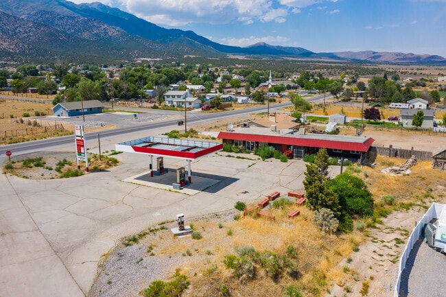

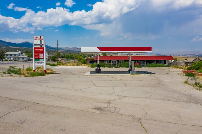
This Property Is For Sale
Property Detail
149 S 200 E
Provo-Orem-Lehi, UT
COM S 801.4 FT & W 10.16 FT FR W1/4 COR. SEC. 5, T6S, R2W, SLB&M.; S 1 DEG 33 2 W 108.79 FT; N 88 DEG 15 45 W 122.94 FT; S 1 DEG 41 25 W 89.64 FT; N 57 DEG 42 0 W 99.64 FT; N 51 DEG 11 5 W 91.3 FT; N 0 DEG 57 52 E 84.62 FT; S 89 DEG 54 29 E 282.4 FT
59-037-0088
UTAH
Conveniencestore
Utah
2024
0.82 AC
2025
Utah County
010107
Salt Lake City
2,274 SF
NEARBY LISTINGS FOR SALE OR LEASE
-
-
View all Cedar Valley listings for sale on LoopNet.com
DEMOGRAPHICS near 149 S 200 E
1 mile
3 mile
5 mile
2025 Total Population
135
704
10,801
2030 Population
159
780
12,424
Pop Growth 2025-2030
+ 17.78%
+ 10.80%
+ 15.03%
Average Age
32
35
29
2025 Total Households
39
188
2,701
HH Growth 2025-2030
+ 17.95%
+ 12.23%
+ 16.03%
Median Household Inc
$127,083
$119,642
$114,381
Avg Household Size
3.50
3.70
4.00
2025 Avg HH Vehicles
3.00
3.00
3.00
Median Home Value
$666,666
$535,714
$627,682
Median Year Built
2011
1998
2010
Nearby Places
Map Layers
Map Styles
 Street
 Aerial
Layers
 Traffic
 Biking
Places
Listings with unknown addresses are not visible on the map
- Restaurants
- Banks
- Shops
- Fitness
- Groceries
PUBLIC TRANSPORTATION
AIRPORT
Provo Municipal
Drive
Walk
Distance
Provo Municipal
47 min
33.0 mi
Salt Lake City International
Drive
Walk
Distance
Salt Lake City International
59 min
45.3 mi
Nearby Properties
Address
Land Use
TOTAL SIZE
Lot Size
Zoning
Address
Land Use
TOTAL SIZE
Lot Size
Zoning
591,967 SF
72.65 AC
Address
Land Use
TOTAL SIZE
Lot Size
Zoning
6,506 SF
143.21 AC
Address
Land Use
TOTAL SIZE
Lot Size
Zoning
8,026 SF
2.25 AC
Address
Land Use
TOTAL SIZE
Lot Size
Zoning
6,440 SF
2.76 AC
Address
Land Use
TOTAL SIZE
Lot Size
Zoning
6,066 SF
19.99 AC
Address
Land Use
TOTAL SIZE
Lot Size
Zoning
5,855 SF
9.99 AC
Address
Land Use
TOTAL SIZE
Lot Size
Zoning
4,815 SF
5.44 AC
Address
Land Use
TOTAL SIZE
Lot Size
Zoning
5,848 SF
10.01 AC
Address
Land Use
TOTAL SIZE
Lot Size
Zoning
5,026 SF
4.25 AC
Address
Land Use
TOTAL SIZE
Lot Size
Zoning
Address
Land Use
TOTAL SIZE
Lot Size
Zoning
4,181 SF
1.84 AC
Address
Land Use
TOTAL SIZE
Lot Size
Zoning
Address
Land Use
TOTAL SIZE
Lot Size
Zoning
Address
Land Use
TOTAL SIZE
Lot Size
Zoning
Address
Land Use
TOTAL SIZE
Lot Size
Zoning
4.08 AC
Address
Land Use
TOTAL SIZE
Lot Size
Zoning
Address
Land Use
TOTAL SIZE
Lot Size
Zoning
Address
Land Use
TOTAL SIZE
Lot Size
Zoning
0.27 AC
Address
Land Use
TOTAL SIZE
Lot Size
Zoning
2,400 SF
4.93 AC
RA5
Address
Land Use
TOTAL SIZE
Lot Size
Zoning
Address
Land Use
TOTAL SIZE
Lot Size
Zoning
Address
Land Use
TOTAL SIZE
Lot Size
Zoning
Address
Land Use
TOTAL SIZE
Lot Size
Zoning
Address
Land Use
TOTAL SIZE
Lot Size
Zoning
Address
Land Use
TOTAL SIZE
Lot Size
Zoning
Address
Land Use
TOTAL SIZE
Lot Size
Zoning
The World's #1 Commercial Real Estate Marketplace
Connect with us
© 2026 CoStar Group
The information above has been obtained from sources believed reliable. While we do not doubt its accuracy we have not verified it and make no guarantee, warranty or representation about it. It is your responsibility to independently confirm its accuracy and completeness. Any projections, opinions, assumptions, or estimates used are for example only and do not represent the current or future performance of the property. The value of this transaction to you depends on tax and other factors which should be evaluated by your tax, financial, and legal advisors. You and your advisors should conduct a careful, independent investigation of the property to determine to your satisfaction the suitability of the property for your needs.