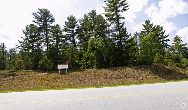
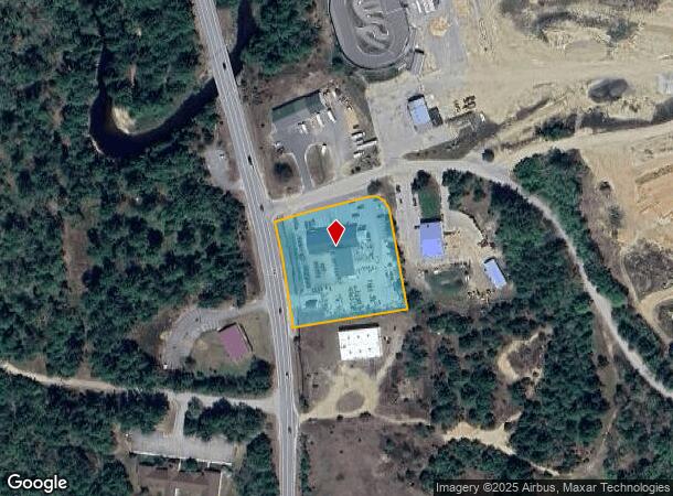
Property Record
149 Sheep Davis Rd, Pembroke, NH 03275
NEARBY LISTINGS FOR SALE OR LEASE
-
-
-
-
-
No Photo
-
-
-
View all Pembroke listings for sale on LoopNet.com
Property Detail
149 Sheep Davis Rd
PMBR-000561-000017-000001
Merrimack
Industrialgeneral
New Hampshire
X
1
33013C0553E
1.70 AC
2024
Concord/New Hampshire North Area
2024
Other Market Areas
003202
Concord, NH
12,060 SF
DEMOGRAPHICS near 149 Sheep Davis Rd
1 Mile
3 Mile
5 Mile
2024 Total Population
414
18,545
43,106
2029 Population
437
19,505
45,382
Pop Growth 2024-2029
+ 5.56%
+ 5.18%
+ 5.28%
Average Age
42
43
43
2024 Total Households
156
8,380
18,299
HH Growth 2024-2029
+ 5.13%
+ 5.05%
+ 5.28%
Median Household Inc
$100,357
$68,409
$76,133
Avg Household Size
2.70
2.10
2.20
2024 Avg HH Vehicles
3.00
2.00
2.00
Median Home Value
$345,348
$257,760
$305,186
Median Year Built
1976
1971
1971
Nearby Places
Map Layers
Map Styles
 Street
 Aerial
- Restaurants
- Banks
- Shops
- Fitness
- Groceries
PUBLIC TRANSPORTATION
AIRPORT
Manchester Boston Regional
DRIVE
WALK
Distance
Manchester Boston Regional
43 min
26.6 mi
Freight Ports
Port of Boston
DRIVE
WALK
Distance
Port of Boston
108 min
75.1 mi
SALE & LEASE HISTORY
LISTING DATE
SALE/LEASE

Sep 24, 2016
For Sale
Nearby Properties
Address
Land Use
TOTAL SIZE
Lot Size
Zoning
Address
Land Use
TOTAL SIZE
Lot Size
Zoning
1,500 SF
RO
Address
Land Use
TOTAL SIZE
Lot Size
Zoning
293,984 SF
IS
Address
Land Use
TOTAL SIZE
Lot Size
Zoning
283,455 SF
80 AC
LO-A
Address
Land Use
TOTAL SIZE
Lot Size
Zoning
156 AC
IS
Address
Land Use
TOTAL SIZE
Lot Size
Zoning
65.25 AC
IN
Address
Land Use
TOTAL SIZE
Lot Size
Zoning
15.59 AC
GWP
Address
Land Use
TOTAL SIZE
Lot Size
Zoning
20 AC
RH
Address
Land Use
TOTAL SIZE
Lot Size
Zoning
11,576 SF
191 AC
C-1A
Address
Land Use
TOTAL SIZE
Lot Size
Zoning
41.49 AC
CG
Address
Land Use
TOTAL SIZE
Lot Size
Zoning
194,386 SF
33.30 AC
GWP
Address
Land Use
TOTAL SIZE
Lot Size
Zoning
79,703 SF
2.16 AC
CVP
Address
Land Use
TOTAL SIZE
Lot Size
Zoning
110 AC
IN
Address
Land Use
TOTAL SIZE
Lot Size
Zoning
75,917 SF
0.30 AC
CBP
Address
Land Use
TOTAL SIZE
Lot Size
Zoning
5 AC
C
Address
Land Use
TOTAL SIZE
Lot Size
Zoning
13.23 AC
RH
Address
Land Use
TOTAL SIZE
Lot Size
Zoning
142,137 SF
10.23 AC
OFP
Address
Land Use
TOTAL SIZE
Lot Size
Zoning
21.45 AC
RH
Address
Land Use
TOTAL SIZE
Lot Size
Zoning
15.22 AC
OCP
Address
Land Use
TOTAL SIZE
Lot Size
Zoning
121,292 SF
10.69 AC
GWP
Address
Land Use
TOTAL SIZE
Lot Size
Zoning
41.95 AC
IN
Address
Land Use
TOTAL SIZE
Lot Size
Zoning
26.72 AC
IN
Address
Land Use
TOTAL SIZE
Lot Size
Zoning
7.48 AC
RM
Address
Land Use
TOTAL SIZE
Lot Size
Zoning
50.19 AC
GWP
Address
Land Use
TOTAL SIZE
Lot Size
Zoning
34.94 AC
RM
Address
Land Use
TOTAL SIZE
Lot Size
Zoning
136,536 SF
17.69 AC
GWP
Address
Land Use
TOTAL SIZE
Lot Size
Zoning
135,161 SF
36.20 AC
GWP
Address
Land Use
TOTAL SIZE
Lot Size
Zoning
114,620 SF
12.89 AC
GWP
Address
Land Use
TOTAL SIZE
Lot Size
Zoning
65,868 SF
10.60 AC
GWP
Address
Land Use
TOTAL SIZE
Lot Size
Zoning
132,828 SF
1.31 AC
CBP
Address
Land Use
TOTAL SIZE
Lot Size
Zoning
76,705 SF
11.11 AC
CH
The World's #1 Commercial Real Estate Marketplace
Connect with us
© 2025 CoStar Group
The information above has been obtained from sources believed reliable. While we do not doubt its accuracy we have not verified it and make no guarantee, warranty or representation about it. It is your responsibility to independently confirm its accuracy and completeness. Any projections, opinions, assumptions, or estimates used are for example only and do not represent the current or future performance of the property. The value of this transaction to you depends on tax and other factors which should be evaluated by your tax, financial, and legal advisors. You and your advisors should conduct a careful, independent investigation of the property to determine to your satisfaction the suitability of the property for your needs.