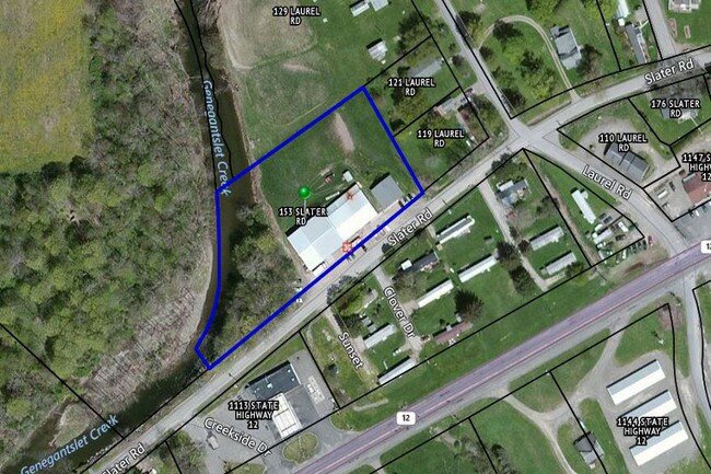
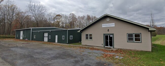
Property Record
149 Slater Rd, Greene, NY 13778

Current Lease Availabilities
Property Detail
149 Slater Rd
083089-247-000-0002-029-300-0000
Chenango
Warehouse
New York
A Areas with a 1% annual chance of flooding and a 26% chance of flooding over the life of a 30-year mortgage.
29.300
2025
2 AC
2025
New York Southeast Area
971000
Other Market Areas
9,525 SF
NEARBY LISTINGS FOR SALE OR LEASE
-
-
View all Greene listings for lease on LoopNet.com
DEMOGRAPHICS near 149 Slater Rd
1 mile
3 mile
5 mile
2025 Total Population
525
3,412
5,925
2030 Population
520
3,376
5,856
Pop Growth 2025-2030
(0.95%)
(1.06%)
(1.16%)
Average Age
44
43
44
2025 Total Households
236
1,510
2,554
HH Growth 2025-2030
(0.85%)
(0.99%)
(1.10%)
Median Household Inc
$59,166
$65,321
$70,086
Avg Household Size
2.20
2.20
2.30
2025 Avg HH Vehicles
2.00
2.00
2.00
Median Home Value
$166,666
$170,267
$172,052
Median Year Built
1970
1968
1970
Nearby Places
Map Layers
Map Styles
 Street
 Aerial
Transit
 Traffic
 Biking
Places
Listings with unknown addresses are not visible on the map
- Restaurants
- Banks
- Shops
- Fitness
- Groceries
Nearby Properties
Address
Land Use
TOTAL SIZE
Lot Size
Zoning
Address
Land Use
TOTAL SIZE
Lot Size
Zoning
44,400 SF
30.16 AC
Address
Land Use
TOTAL SIZE
Lot Size
Zoning
23.10 AC
Address
Land Use
TOTAL SIZE
Lot Size
Zoning
130.04 AC
Address
Land Use
TOTAL SIZE
Lot Size
Zoning
119.07 AC
Address
Land Use
TOTAL SIZE
Lot Size
Zoning
0.01 AC
Address
Land Use
TOTAL SIZE
Lot Size
Zoning
0.01 AC
Address
Land Use
TOTAL SIZE
Lot Size
Zoning
42,230 SF
0.32 AC
COMM
Address
Land Use
TOTAL SIZE
Lot Size
Zoning
41,000 SF
3.94 AC
RESID
Address
Land Use
TOTAL SIZE
Lot Size
Zoning
7,835 SF
0.38 AC
RESID
Address
Land Use
TOTAL SIZE
Lot Size
Zoning
76,000 SF
8.53 AC
Address
Land Use
TOTAL SIZE
Lot Size
Zoning
20,012 SF
4.40 AC
Address
Land Use
TOTAL SIZE
Lot Size
Zoning
1,080 SF
4.44 AC
MUNIC
Address
Land Use
TOTAL SIZE
Lot Size
Zoning
4,720 SF
4.24 AC
Address
Land Use
TOTAL SIZE
Lot Size
Zoning
8,788 SF
0.67 AC
COMM
Address
Land Use
TOTAL SIZE
Lot Size
Zoning
Address
Land Use
TOTAL SIZE
Lot Size
Zoning
19,200 SF
3.76 AC
RES
Address
Land Use
TOTAL SIZE
Lot Size
Zoning
840 SF
36.28 AC
Address
Land Use
TOTAL SIZE
Lot Size
Zoning
9,800 SF
120.28 AC
Address
Land Use
TOTAL SIZE
Lot Size
Zoning
18,404 SF
31.99 AC
Address
Land Use
TOTAL SIZE
Lot Size
Zoning
3,400 SF
6.53 AC
INDUS
Address
Land Use
TOTAL SIZE
Lot Size
Zoning
2,992 SF
0.89 AC
Address
Land Use
TOTAL SIZE
Lot Size
Zoning
10,750 SF
10.25 AC
03
Address
Land Use
TOTAL SIZE
Lot Size
Zoning
6,550 SF
0.86 AC
Address
Land Use
TOTAL SIZE
Lot Size
Zoning
9,100 SF
2.13 AC
Address
Land Use
TOTAL SIZE
Lot Size
Zoning
9,375 SF
6.40 AC
Address
Land Use
TOTAL SIZE
Lot Size
Zoning
21,287 SF
3.02 AC
COMM
Address
Land Use
TOTAL SIZE
Lot Size
Zoning
0.10 AC
COMM
Address
Land Use
TOTAL SIZE
Lot Size
Zoning
5,911 SF
2.44 AC
Address
Land Use
TOTAL SIZE
Lot Size
Zoning
3,000 SF
1.50 AC
Address
Land Use
TOTAL SIZE
Lot Size
Zoning
4,120 SF
1.01 AC
The World's #1 Commercial Real Estate Marketplace
Connect with us
© 2026 CoStar Group
The information above has been obtained from sources believed reliable. While we do not doubt its accuracy we have not verified it and make no guarantee, warranty or representation about it. It is your responsibility to independently confirm its accuracy and completeness. Any projections, opinions, assumptions, or estimates used are for example only and do not represent the current or future performance of the property. The value of this transaction to you depends on tax and other factors which should be evaluated by your tax, financial, and legal advisors. You and your advisors should conduct a careful, independent investigation of the property to determine to your satisfaction the suitability of the property for your needs.